
Local Plan - Submission Version (Regulation 19)
1 Introduction
Welcome to Tendring
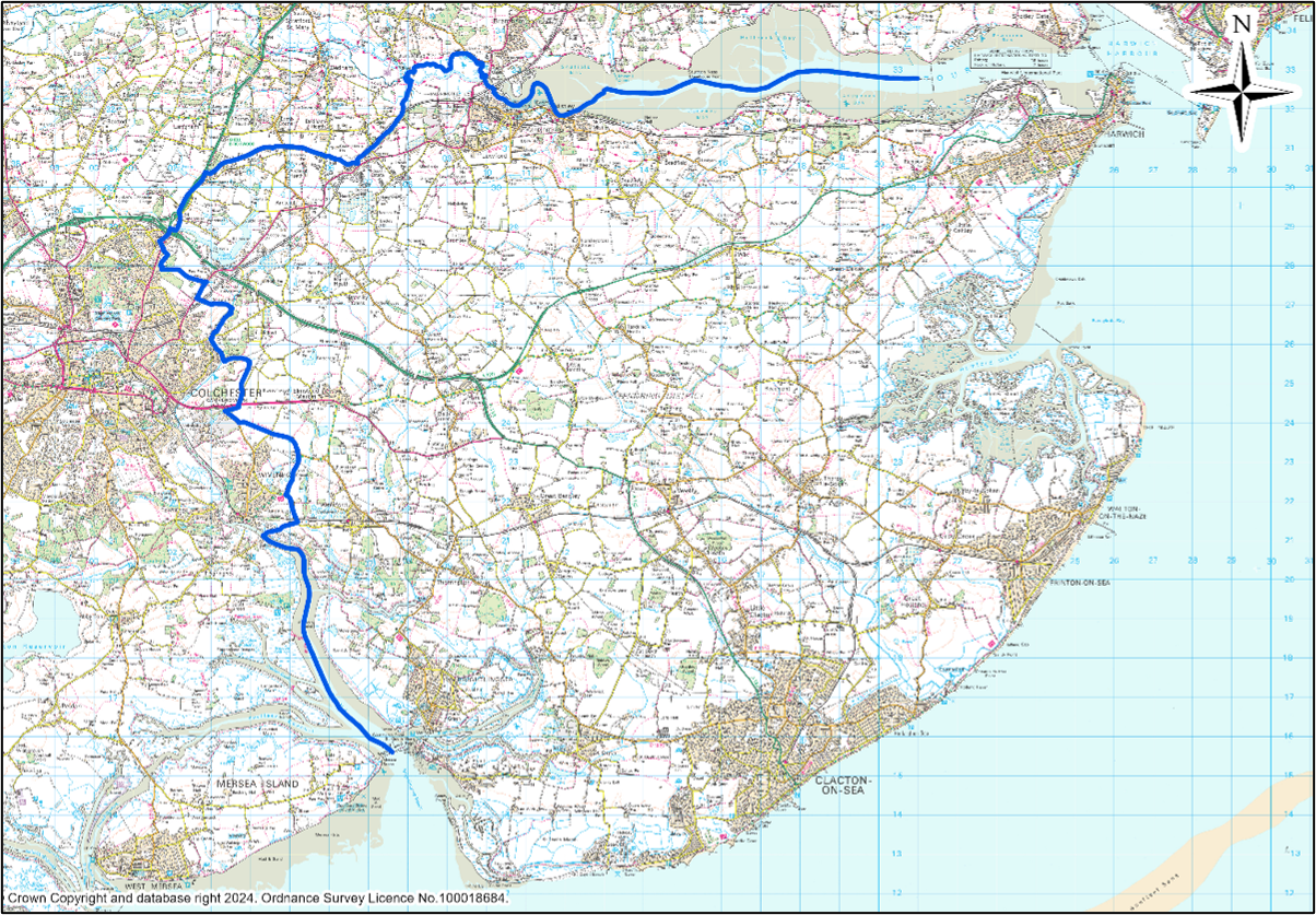
1.1Welcome to the Tendring District Local Plan. Tendring District is located in the north-eastern corner of the county of Essex, bordering Suffolk and approximately 70 miles from London. The Tendring peninsula is bordered by the Stour Estuary to the north, the North Sea to the south and east and the Colne Estuary to the south-west. As a coastal District, Tendring contains a number of individual seaside and riverside towns as well as a large rural heartland. The western edge of our District borders the City of Colchester, one of Essex’s principal urban centres.
1.2The largest urban area within our District is Clacton-on-Sea. Tendring District is also home to the International Port of Harwich; the coastal towns of Frinton-on-Sea and Walton-on-the-Naze; the historic port town of Brightlingsea; Manningtree, a town which borders Suffolk; the Stour Estuary; and the Dedham Vale and Suffolk & Essex Coast and Heaths National Landscapes. Our rural heartlands contain many distinctive villages and hamlets of varying sizes.
1.3Tendring District has a diverse range of assets, including its attractive landscapes, coastline, areas of nature conservation, maritime heritage, a wealth of heritage assets, and both locally and internationally important ports. However, alongside some thriving settlements and successful businesses there are also significant challenges. Parts of Tendring continue to experience comparatively high levels of deprivation, lower wages, poorer health outcomes and fewer local employment opportunities than many other parts of Essex. Historically, some communities have experienced lower levels of investment in transport, utility, health and education infrastructure, creating a substantial gap between existing provision and that required to support future growth. This challenge has become particularly pronounced in light of the significantly increased housing requirement that the Council is now required to plan for through the Local Plan Review.
1.4Tendring also faces ongoing challenges relating to coastal erosion, climate change adaptation and nature recovery. The need to accommodate significant levels of new housing and employment development whilst addressing infrastructure constraints and protecting the District’s sensitive landscapes, estuaries, habitats and historic environment is therefore one of the principal challenges facing this Local Plan Review.
1.5Tendring’s geography has a fundamental influence on the options available for future growth. As a peninsula, bounded by the North Sea and two major estuaries, opportunities for expansion are inherently more limited than in many inland authorities. Large areas of the District are affected by environmental designations, protected habitats, areas at risk from coastal change and flooding, National Landscapes, and other environmental constraints. These factors do not prevent development from taking place, but they significantly influence where growth can be sustainably accommodated, limit the range of realistic options available to the Council, and have played an important role in shaping the spatial strategy contained within this Local Plan.
Map 1 Tendring District Boundary
The Local Plan Review
1.6Tendring District Council is undertaking a review of its Local Plan to ensure it remains up to date and continues to provide a clear and robust framework for guiding development across the District. National planning policy requires Local Plans to be reviewed at least every five years and updated where necessary. The review is taking place against a significantly different national policy context to that which informed the adopted Plan, including the introduction of a substantially increased mandatory housing requirement for Tendring. As a result, the Council has been required to revisit earlier assumptions about the scale and distribution of future growth and consider strategic approaches capable of accommodating levels of development beyond anything previously planned for in the District and significantly greater than those anticipated when work on the review initially commenced. The scale of growth now required creates important considerations relating to infrastructure provision, environmental protection, landscape character, and the long-term sustainability of communities across the District. The updated Local Plan will set out how the District will accommodate future housing, employment and infrastructure needs in a sustainable way, while protecting the environment and maintaining the character of our towns and villages.
1.7 The review is not a complete re-write of the Local Plan but an update that builds on the foundations of the current Plan. While the review builds upon the successful framework established through the adopted Local Plan, the scale of housing growth now required by national policy is unprecedented for Tendring and necessitates consideration of development opportunities and strategic approaches that would not previously have been required. It will carry forward many of the existing policies that remain relevant, while introducing new policies and proposals to reflect the latest evidence, national requirements and local priorities. The updated Local Plan identifies additional sites for housing and employment development to meet the Government’s mandatory housing target of at least 18,173 new homes between 2026 and 2043, alongside policies to secure infrastructure, protect biodiversity, and address climate change. The scale of growth now required represents a significant departure from that envisaged through the adopted Local Plan and requires the identification of additional opportunities for development across a wider area of the District.
1.8Meeting the Government’s mandatory housing requirement presents a significant challenge. Existing allocations, commitments and developments under construction are expected to make a major contribution towards future housing supply, however additional land must still be identified to accommodate thousands of further homes over the Plan period. The Council has therefore undertaken a comprehensive assessment of potential growth options, locations and sites, supported by technical evidence, sustainability appraisal and stakeholder engagement, to identify the most sustainable, deliverable and viable strategy for the District. In developing the strategy, the Council has not simply considered where development might be accommodated, but also whether alternative approaches were capable of sustainably delivering the scale of growth required. Through this process, a number of potential approaches were found to be constrained by environmental designations, landscape considerations, infrastructure limitations, settlement characteristics and deliverability considerations. The strategy contained within this Local Plan reflects the outcome of that assessment process.
1.9The mandatory housing requirement for Tendring has increased substantially since the adoption of the current Local Plan and now requires the District to plan for a level of growth without precedent in its history. Accommodating this growth in a sustainable manner will require significant investment in transport, education, healthcare, utilities and community infrastructure whilst ensuring that the District's environment, landscape character, coastal assets and internationally important habitats are appropriately protected and enhanced. This will present challenges for existing communities and service providers and will require careful planning to ensure that growth is supported by the facilities, jobs and infrastructure needed to create sustainable places.
1.10Once adopted, Section 1 (strategic policies prepared jointly with Colchester and Braintree Councils) and Section 2 (policies specific to Tendring) of the current Local Plan will be superseded by the updated Local Plan. This means that all planning decisions will be made in accordance with the new Plan, which will become the statutory development plan for the District. The Local Plan also provides the broad framework of policies and proposals to which individual communities can, if they wish, add further detail and more local requirements by preparing their own ‘Neighbourhood Plans’.
1.11 The Local Plan Review is therefore critical to ensuring that Tendring can manage growth positively and proactively, rather than leaving the District vulnerable to speculative and unplanned development. The review provides the opportunity to direct growth towards the most sustainable and deliverable locations, ensure that new development contributes towards infrastructure improvements and environmental enhancement, and demonstrate how the District can respond positively to national planning policy whilst recognising the particular opportunities and constraints that make Tendring distinctive. Through the review process, a range of alternative approaches to accommodating growth have been considered and tested to ensure that the chosen strategy represents the most appropriate balance between meeting development needs and protecting the special qualities of the District.
1.12In preparing this Local Plan, the Council has also had regard to the fact that neighbouring authorities are themselves seeking to address significant development requirements through their own Local Plans and are not assumed to have capacity to accommodate unmet development needs arising from Tendring. Consequently, the Plan has been prepared on the basis that Tendring should seek, wherever possible, to meet its own identified development needs within the District's boundaries. The evidence informing this process is summarised throughout this Local Plan and explained in greater detail within the supporting evidence base documents prepared as part of the review.
1.13The Local Plan sets out the spatial strategy for where new development will take place, the infrastructure needed to support it, and the policies that will guide the design and quality of new homes, jobs and community facilities. Through this process, the Council aims to balance the need for growth with the protection of the environment and the creation of healthy, sustainable and well-connected communities.
1.14The review also comes at a time of wider change. With Local Government Reorganisation and the creation of a Mayoral Combined County Authority for Greater Essex on the horizon, this Local Plan is likely to be the last prepared by Tendring District Council in its current form. It will therefore play an important role in shaping the future of the District and influencing strategic planning decisions for the wider area.
1.15Public engagement has been central to the preparation of this Local Plan. In accordance with the Council’s Statement of Community Involvement (SCI), consultation has been undertaken at key stages of the review, including the Issues and Options consultation (March - April 2025) and the Preferred Options consultation (February - March 2026). The feedback received through these consultations, alongside ongoing engagement with statutory consultees, infrastructure providers, neighbouring authorities, local communities and other stakeholders has helped shape the Plan’s strategy, policies and site allocations.
1.16The Submission Version consultation is not intended to seek further changes to the Plan, but instead provides an opportunity for interested parties to make representations on whether the Local Plan has been prepared in accordance with legal and procedural requirements and whether it satisfies the tests of soundness set out in national planning policy, prior to its submission for independent examination.
Context
1.17The Local Plan needs to be consistent with a wide range of other policies, guidance, strategies and plans produced not only by this Council but also by central government, neighbouring authorities and other public bodies. Although the ‘Duty to Cooperate’ has been removed from the Localism Act, the Council remains responsible for maintaining effective cooperation with other organisations and neighbouring authorities. In preparing this Local Plan, the Council has also had regard to the fact that neighbouring authorities are themselves seeking to address significant development requirements through their own Local Plans and are not assumed to have capacity to accommodate unmet development needs arising from Tendring. Consequently, the Plan has been prepared on the basis that Tendring should seek, wherever possible, to meet its own identified development needs within the District's boundaries.
1.18The following section identifies other policies, guidance, strategies and plans that informed the content of this Local Plan along with the key national and local partnerships that will be involved in delivering positive changes in the area over the plan period.
National Planning Policy Framework (NPPF)
1.19The National Planning Policy Framework (NPPF), first introduced by the Government on 27 March 2012, has since undergone several revisions, most recently on 12 December 2024 and amended on 7 February 2025. The revised Framework sets out the Government’s planning policies for England and how these are expected to be applied. Local planning authorities must ensure that their Local Plans are consistent with the NPPF’s objectives, principles and policies. The Framework continues to promote the achievement of sustainable development and requires councils to prepare and maintain up‑to‑date plans that meet identified development needs in a flexible and responsive manner. The NPPF is also a material consideration in the determination of planning applications alongside the policies contained in the statutory development plan.
Essex County Council
1.20Essex County Council is the Local Highway Authority, with a responsibility to manage and maintain the highway network, and the Local Transport Authority, with transport planning responsibilities for the administrative area of Essex. The Essex Local Transport Plan (2011) contains the Essex Transport Strategy (2011) and sets out the 15-year vision to improve travel in the county and underlines the importance of the transport network in achieving sustainable, long term economic growth and enriching the life of residents. It is supplemented by delivery strategies for public transport, highways, cycling and public rights of way. Essex County Council is progressing the replacement of the Essex Transport Strategy (2011) with the Local Transport Plan 4 (LTP4), which is anticipated to be adopted in 2026. Essex County Council is also the Waste Disposal Authority, Minerals and Planning Authority, and Lead Local Flood Authority and is responsible for advising on public health, providing Specialist and Supported Housing, and leading the Essex Local Nature Recovery Strategy. Essex County Council is also responsible for delivering education, including Early Years and Childcare, Special Education Needs and Disabilities, and Post 16 Education.
Essex Minerals Local Plan
1.21Essex County Council is the Minerals Planning Authority for the District and is responsible for preparing planning policies and determining applications for mineral development. The Essex Minerals Local Plan (adopted 2014 and covering the period to 2029) forms part of the statutory Development Plan and should be read alongside the Tendring Local Plan. The Minerals Local Plan is currently undergoing a review, with a Replacement Essex Minerals Local Plan proposed to cover the period 2025-2040. Its role remains to identify sites for the extraction of sufficient quantities of mineral within Essex to facilitate development over the Plan period.
1.22There are active quarry sites within the District, as well as unworked sand and gravel deposits which are subject to a Minerals Safeguarding Policy within the Essex Minerals Local Plan. Policy S8 requires Essex County Council, as the Minerals Planning Authority, to be consulted on development proposals of 5 hectares or more within the designated sand and gravel Minerals Safeguarding Area. Where development falls within a Minerals Safeguarding Area, regard should be had to the requirements of the Minerals Local Plan (including any emerging policies in the reviewed Plan).
1.23 The Minerals Local Plan also identifies Mineral Consultation Areas (MCAs), extending 250 metres around active quarries, mineral infrastructure, and mineral deposits permitted for extraction. Essex County Council must be consulted on all non-mineral related development within these areas to ensure that mineral resources and associated operations are not prejudiced.
Essex and Southend-on-Sea Waste Local Plan
1.24 Essex County Council is the Waste Planning Authority for the District and is responsible for preparing planning policies and assessing applications for waste management development. The Essex and Southend-on-Sea Waste Local Plan (adopted in 2017) is part of the statutory Development Plan which should be read alongside the Tendring Local Plan. The Plan sets out how waste will be managed across Essex and Southend-on-Sea, including the long-term strategy, development management policies and strategic site allocations, and provides the planning policy framework against which waste-related development proposals are assessed.
1.25The Essex and Southend-on-Sea Waste Local Plan allocates new waste development at Slough Farm, Ardleigh; Morses Lane, Brightlingsea; Sunnymead, Elmstead; and Heath Farms, northwest of Alresford. It also identifies Areas of Search to meet the need for additional small scale waste management facilities, focussing on existing industrial estates that are suitably located away from sensitive uses such as housing, schools, retail, leisure, and offices. One such Area of Search within Tendring is the Martell’s Farm Industrial Area. The Waste Local Plan also designates Waste Consultation Areas at a distance of 250 metres around permitted waste management facilities and 400 metres around water recycling centres. Essex County Council must be consulted on all non-waste related development within these areas to ensure that waste infrastructure is safeguarded.
South East Marine Plan
1.26In accordance with Section 58(3) of the Marine and Coastal Access Act (MCAA) 2009, all public authorities capable of affecting the UK marine area must have regard to the relevant marine plan and the UK Marine Policy Statement. As the Local Plan will affect areas with coastal influence, Tendring District Council must consider the South East Marine Plan, a statutory plan and policy framework, to inform decision-making taking place in the marine environment. The objectives and policies cover a plan period of 20 years, setting out how the marine environment is to be developed, protected and improved whilst balancing other environmental, economic, and social factors. The South East Marine Plan has been produced by the Marine Management Organisation, in partnership with local and national stakeholders from a diverse range of sectors.
Working in Partnership
1.27Whilst the Council’s Planning Department has overseen the preparation of the Local Plan, it is far more than just a planning document. It is of high importance to all services within the Council and many of the partners that we work with. The Local Plan can inform and be informed by the strategies of different organisations because working in genuine partnership will ultimately produce the best results on the ground. The responsibility of maintaining effective cooperation places an onus on Councils to demonstrate that Local Plans have been prepared in partnership with other bodies.
Tendring District Council Strategies
1.28Tendring District Corporate Plan – The Council’s Corporate Plan sets out the Council’s vision and priorities for the future as an organisation. It is important to ensure that the objectives of the Local Plan and Corporate Plan are aligned.
1.29Other Council Strategies – Other than the Corporate Plan, the Council also has a variety of other plans and strategies that the Local Plan reflects and, where possible, supports. Relevant plans and strategies include:
- Community Safety Delivery Plan;
- Housing Strategy;
- Economic Development Strategy;
- Heritage Strategy;
- Creative and Cultural Strategy; and
- Tourism Strategy.
The Plans of Neighbouring Authorities
1.30The Council must recognise the strategies and emerging plans of neighbouring authorities. Tendring’s adjoining neighbours are Colchester City Council and Babergh District Council. While the wider strategic area has historically been defined by a shared ‘Housing Market Area’ with Braintree, Colchester and Chelmsford, the most recent evidence indicates that Tendring functions as a distinct housing market area with important but more limited linkages to neighbouring authorities. Nevertheless, the Council continues to work collaboratively with the North Essex authorities on strategic planning matters where there are cross‑boundary issues or shared interests. Babergh is not part of Tendring’s Housing Market Area but still has an important functional relationship with Tendring.
1.31Babergh District lies to the north of both Tendring and Colchester, within Suffolk. Babergh and Mid Suffolk District Councils adopted Part 1 of their Joint Local Plan in November 2023, setting the development strategy for the period to 2037. The Councils are now progressing a full Joint Local Plan Review, following changes to the National Planning Policy Framework in December 2024, with the new plan set to guide development into the mid‑2040s.
1.32Brantham, located close to the Tendring boundary, maintains strong service and functional connections with Manningtree. Development proposals in Brantham—including housing, employment or retail—may influence infrastructure, services and environmental impacts within Tendring. Likewise, Tendring’s proposals for Manningtree, Lawford and Mistley have reciprocal effects for Babergh. Both authorities will therefore continue to work together to ensure cross‑border development achieves positive economic outcomes, high‑quality design and appropriate infrastructure delivery.
1.33Both Tendring and Babergh also have a joint interest in the Suffolk Coast and Heaths National Landscape (formerly AONB) which now extends across the southern part of the Stour Estuary. Ongoing cooperation will ensure that development within both districts conserves and enhances the natural beauty, landscape character and environmental quality of this protected area.
Local Government Reorganisation
1.34Proposed Devolution and Local Government Reorganisation (LGR) in Greater Essex provide important context for this Local Plan Review. From 2026, strategic planning powers are expected to transfer to a new Mayoral Combined County Authority (MCCA), with a transition to unitary local government structures anticipated from 2028. Given the scale of the proposed changes, this Review is likely to be the final Local Plan prepared by Tendring District Council in its current form. Adoption of a new Local Plan will ensure that an up‑to‑date, locally prepared framework for managing growth in Tendring is in place for the successor unitary authority.
1.35Once adopted, the updated Local Plan will continue to guide planning decisions in the District and will also inform the preparation of the MCCA’s first 30‑year Spatial Development Strategy. Strategic proposals such as the Garden Villages at Hare Green and Horsley Cross will therefore play an important role in shaping long‑term growth across the wider Greater Essex area.
Other Necessary Assessments
1.36Given the scale of development required through this Plan and the environmental, infrastructure and geographical constraints affecting the District, the Council has placed particular emphasis on maintaining a robust and proportionate evidence base. The spatial strategy and site allocations proposed in this Local Plan have been informed by a wide range of technical studies including the Sustainability Appraisal, Strategic Housing Land Availability Assessment, settlement hierarchy evidence, landscape character assessment, transport and infrastructure evidence, environmental assessments and consultation responses received throughout the review process. Together, this evidence has informed the assessment of reasonable alternatives and the selection of the most appropriate strategy for accommodating future growth.
1.37The Council has a statutory requirement to carry out a number of assessments, in accordance with European and national legislation to ensure that the implications of policies and proposals in the Local Plan have been fully understood. Such assessments include:
Sustainability Appraisal (SA): This helps to ensure that Local Plans and other planning documents have a sound understanding of the environmental, social and economic characteristics and priorities of the area. The Sustainability Appraisal for this version of the draft Local Plan will be consulted upon.
Strategic Environmental Assessment (SEA): The SEA is required by a European Directive to assess the environmental effects of policies and proposals in Local Plans. The SEA is incorporated into the SA in English law.
Habitats Regulation Assessment (HRA): An HRA is a requirement of the European Habitats Directive and for Tendring District is necessary to assess the impact of Local Plan’s policies and proposals on our three sites of international importance for wildlife – Hamford Water, the Colne Estuary and the Stour Estuary. An HRA has been prepared for the Preferred Options version of the Local Plan.
Equality Impact Assessment (EqIA): An Equality Impact Assessment is designed to ensure that plan makers think carefully about the likely impacts of their plans on different groups of society to ensure that people are not being discriminated against and the needs of all the population are being addressed. An EqIA has been prepared for the Preferred Options version of the Local Plan.
