Hartley Gardens Supplementary Planning Document
4.1. The evolution of the Site allocation has been an iterative process, shaped by Stage 1 community and stakeholder engagement, technical workstreams, and a focus on placemaking. This followed on from 'Topic Paper 6: Hartley Gardens' produced by TDC to inform the Independent Examination of Section 2 of the Tendring District Local Plan. Each stage of the process has refined the concept, integrating feedback, addressing site constraints, and prioritising high-quality design to create a well-connected and sustainable neighbourhood. This collaborative approach ensures that the Site will meet the needs of its future residents while respecting the natural and built environment.
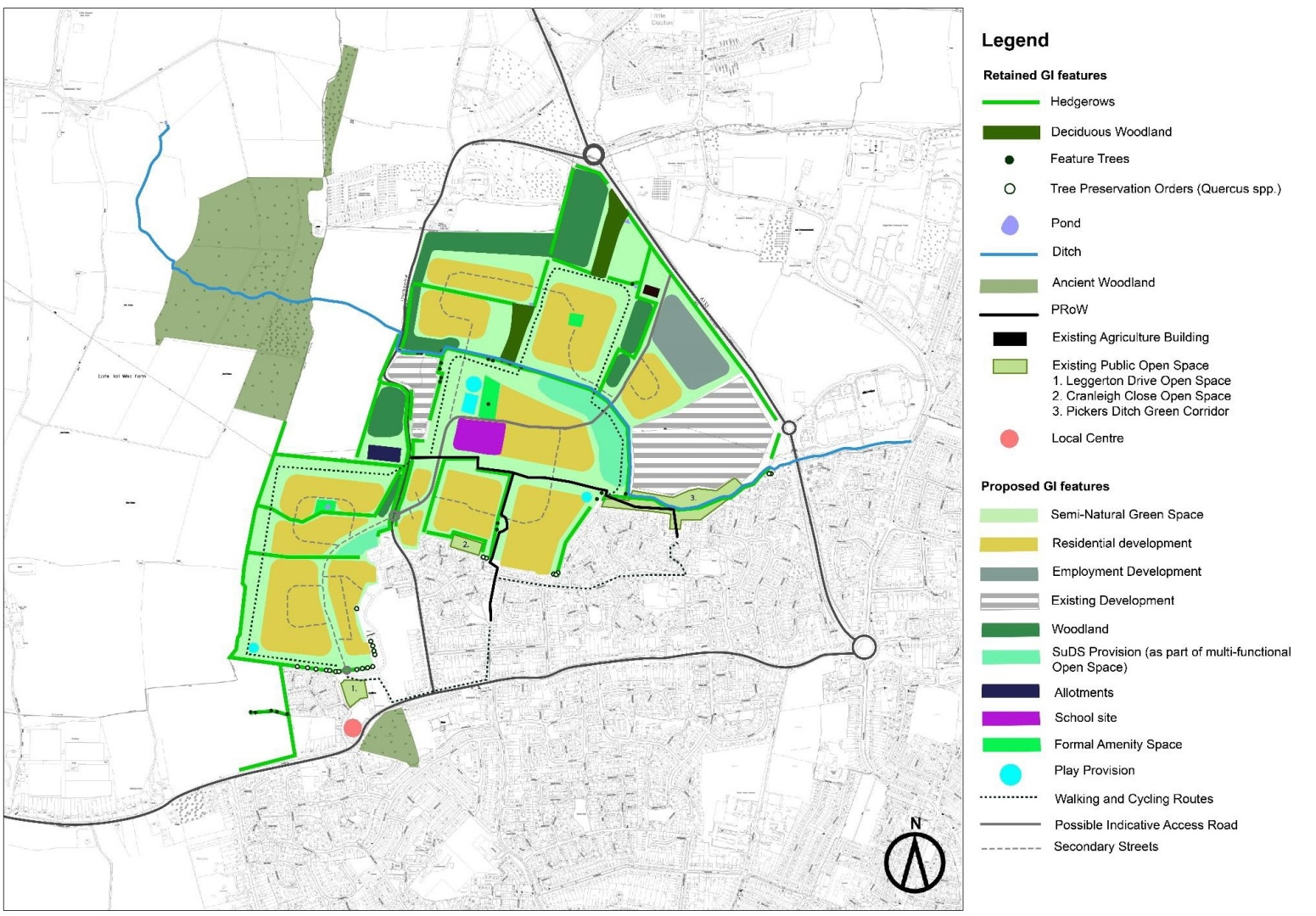
A Preliminary Concept Framework was developed to demonstrate that the proposed Site allocation could accommodate all land use and infrastructure requirements outlined in Policy SAMU2 and address the Site constraints identified in Topic Paper 6 – part of evidence base to inform the Hartley Gardens Site allocation. The Preliminary Concept Framework outlined a potential development scenario, evaluated the Site's ability to achieve a 10% Biodiversity Net Gain, and set clear parameters and design principles to guide further masterplanning.
The concept was strongly structured around integrated active travel networks and green and blue infrastructure corridors, connecting the Site to the existing town and its communities.
An Initial Optioneering Study aimed to ensure that the development of the land would be viable, deliverable, and aligned with Building for a Healthy Life design standards. As part of this process, capacity proving and masterplanning was undertaken. The resulting plan integrated technical, legal, and policy inputs and assume cooperation among stakeholders or a comprehensive land assembly process. The masterplan envisioned a development of approximately 1,700 homes, supported by required social and physical infrastructure, extensive public open spaces, and biodiversity enhancements.
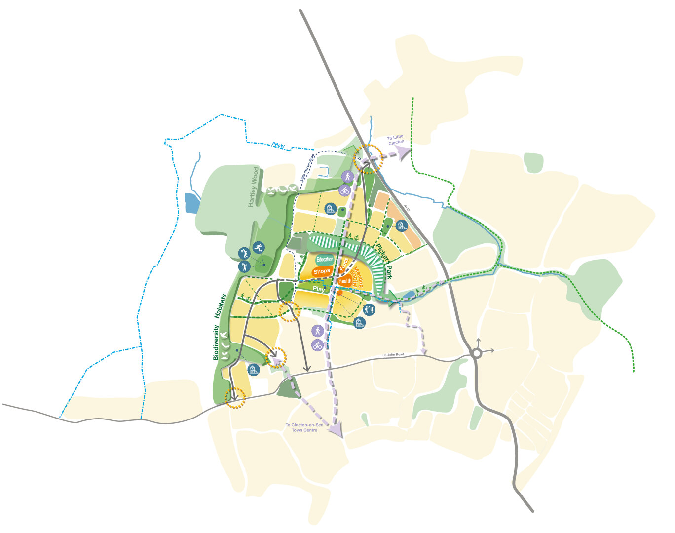
Key design features included a significant open space in the north-western corner, and a network of green corridors connecting to Clacton-on-Sea, and local amenities. The plan included a primary school, a local centre with pedestrian-priority public spaces, and areas for play to support placemaking. Heritage assets and existing properties are sensitively integrated, while strategic SuDS and habitat creation are incorporated into the green infrastructure.
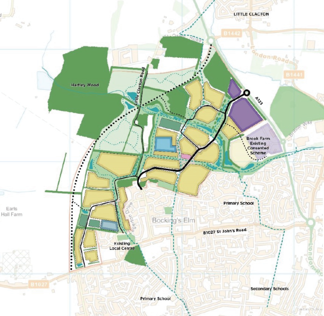
The Emerging Concept Plan 2023 was informed by engagement with the local community during Stage 1, incorporating feedback and ongoing Site surveys to better understand the area. It explored options for housing types, local facilities, access routes, transport, and community infrastructure, focusing on how these elements should be arranged within the Site. An opportunities and constraints assessment highlighted key considerations, including green links to integrate the Site into the wider landscape.
The plan emphasised protecting and enhancing natural assets, particularly around Pickers Ditch. It included a comprehensive green infrastructure network, with trees and vegetation woven through residential neighbourhoods, leading to a revitalised park along Pickers Ditch. The general design was shaped by the surrounding landscape, considering views from local footpaths and neighbouring properties, with visual impacts minimised through mitigation measures.
Following a Space Syntax assessment, the neighbourhood centre was strategically located at the intersection of existing and future routes, ensuring strong connections to the wider settlement while providing local amenities for the new community.
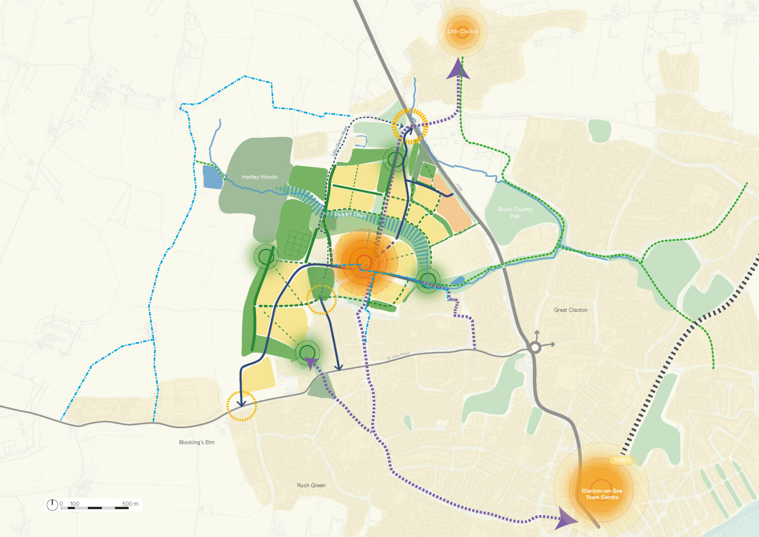
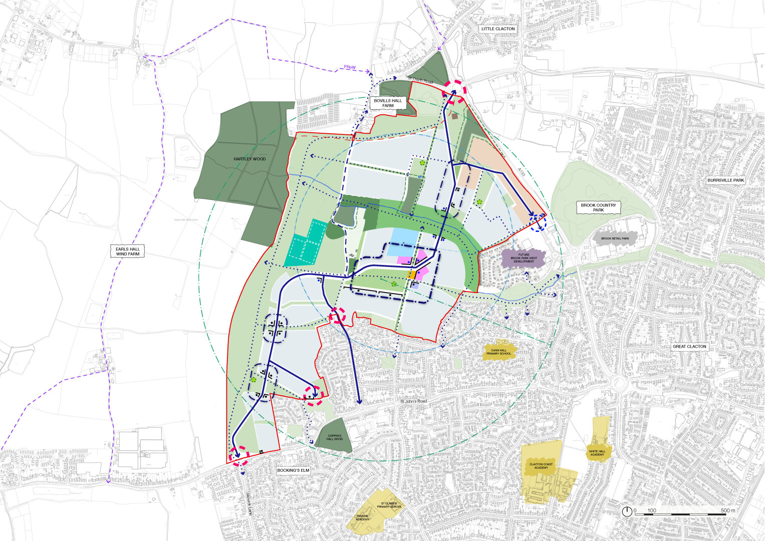
The Revised Concept Plan 2024 was designed around a central Neighbourhood Park, connected by green links that integrate community facilities, destination play areas, a primary school, a nursery, and the local centre into the wider neighbourhood. Following Stage 1 stakeholder engagement, including input from Natural England, it was agreed that approximately 40 hectares of open space would be provided, comprising two large open spaces with complementary areas throughout the development.
The school's location was determined in consultation with ECC, prioritising pedestrian friendly design over car-dominated streets. The school has clear visual and physical connections to the Neighbourhood Centre, public square, and Neighbourhood Park, with active frontages facing Pickers Park, green links, and nearby residential areas. Employment areas were situated near the A133 and existing commercial hubs for accessibility and providing a noise buffer to residential areas.
Traffic surveys, technical assessments, and an options analysis informed the access strategy. The strategy aims to disperse traffic along key transport corridors. A four-point access solution is agreed in principle with ECC subject to further technical work being undertaken at detailed planning application stage.
A network of green links was established to provide pedestrian and cyclist-friendly connections throughout the development. These links include formal routes south to Clacton and east to the retail park, as well as more natural pathways.
Further technical work focused on infrastructure provision and sequencing to inform the preparation of this SPD and a Spatial Framework. The technical work undertaken supports the provision of approximately 1,870 homes in addition to the Neighbourhood Centre, primary school, early years education, community hub (a flexible space that can accommodate health facilities), and employment.
Proposed Spatial Framework
4.2. The Development Principles for the Spatial Framework have been informed by the assessment of the Site and its context and engagement with stakeholders and the community, as detailed in Section 2. They establish the vision for how the Site will integrate into Clacton-on-Sea.
4.3. A landscape approach focussed on protecting and enhancing existing green (green space) and blue (water) infrastructure; integrating the local landscape character, creating a multifunctional, accessible, and connected landscape that will integrate the Site into the wider landscape context.
4.4. An access and movement approach that accommodates all modes of transport but maximises opportunities for active and sustainable travel choices through its design and connections.
4.5. The creation of four distinct character areas within the Site, reflecting existing natural and built features and the Site's relationship to Clacton-on-Sea, whilst delivering a sense of place and opportunities for all.
4.6. Approach sustainability positively to reduce resources used through passive and active measures and the use of low and renewable energy sources, as well as ensuring timely provision and use of shared spaces, community facilities, and other local services to enhance the sustainability of the development and neighbouring communities and residential environments.
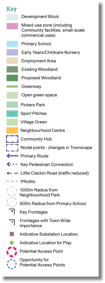
4.7. The Spatial Framework has been designed to provide a comprehensive spatial strategy. In preparing the SPD and Spatial Framework, land budgets, densities, and infrastructure implications have been considered which support the delivery of approximately 1,870 homes in accordance with LPS2 Policy SAMU2.
4.8. The Spatial Framework and the Development Principles set out in Section 5 will be used in the preparation and assessment of future planning applications and form an important material consideration in their determination. TDC will only accept future deviations to the Spatial Framework where proposals:
- Are supported by robust evidence.
- Do not conflict or prejudice the delivery of the wider Site development, including its infrastructure requirements, and would not undermine the integrated and co-ordinated approach to the wider development.
- Demonstrably conform to the policy requirements and principles of LPS2, Policy SAMU2, and the principles established within this SPD.