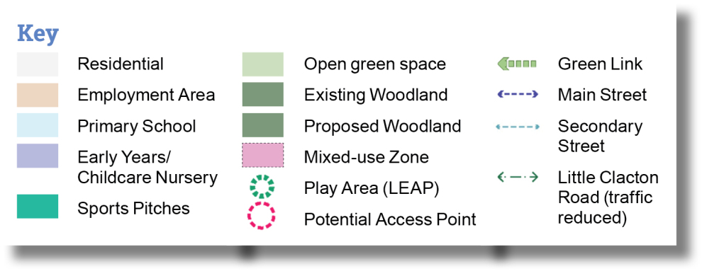
Hartley Gardens Supplementary Planning Document
Introduction
5.1. This Section of the SPD sets out Sitewide Development Principles that have been informed by a process which has included the assessment of the Site’s constraints and opportunities and engagement with the community and key stakeholders, as set out in Section 3 Assessment. The Development Principles will underpin the delivery of the Vision and Objectives for the Site set out in Section 3, to ensure comprehensive development and create a new neighbourhood with a coherent identity. This SPD will be used to inform Design Codes prepared to support planning applications for development proposals within the Site which will ensure that the SPD design principles are transferred through to detailed design stage.
5.2. The Development Principles provide further guidance to the principles set out in LPS2, Policy SAMU2, and have also been informed by consideration of the following documents.
- National Design Guide (2021)3.
- The National Model Design Guide (2021)4.
- Building for a Healthy Life (2020)5.
- Streets for a Healthy Life: a companion guide to Building for a Healthy Life (2022)6.
- Sport England’s Active Design Guidance (2023)7.
- Building with Nature (including an application for a BwN Design Award)8.
- Essex Design Guide9.
- Manual for Streets Part 1 and Part 210.
- Cycle Infrastructure Design (LTN1/20)11.
- Bus User Priority (LTN1/24)12.
5.3. Planning applications for proposed development coming forward at the Site must refer to these guidance documents and the Spatial Framework, as detailed in Section 4, as key considerations in the planning application process. The latest available update of these documents should be referred to. Should these differ significantly from the versions identified above, clear justification must be given if a later update cannot be met.
5.4. The Development Principles used in this Section are structured around the following characteristics in the National Design Guide (NDG, 2021):
Context and Identity
Context is the location of the development and the attributes of its immediate, local and regional surroundings.
The identity or character of a place comes from the way that buildings, streets and spaces, landscape and infrastructure combine together and how people experience them.
Public Spaces
The quality of the spaces between buildings is as important as the buildings themselves. Public spaces are streets, squares, and other spaces that are open to all. They are the setting for most movement. The design of a public space encompasses its siting and integration into the wider network of routes as well as its various elements. These include areas allocated to different users – cars, cyclists and pedestrians –for different purposes such as movement or parking, hard and soft surfaces, street furniture, lighting, signage and public art.
Built Form
Built form is the three-dimensional pattern or arrangement of development blocks, streets, buildings and open spaces. It is the interrelationship between all these elements that creates an attractive place to live, work and visit, rather than their individual characteristics. Together they create the built environment and contribute to its character and sense of place. Uses Sustainable places include a mix of uses that support everyday activities, including to live, work and play. Well-designed neighbourhoods need to include an integrated mix of tenures and housing types that reflect local housing need and market demand. They are designed to be inclusive and to meet the changing needs of people of different ages and abilities.
Uses
Sustainable places include a mix of uses that support everyday activities, including to live, work and play. Well-designed neighbourhoods need to include an integrated mix of tenures and housing types that reflect local housing need and market demand. They are designed to be inclusive and to meet the changing needs of people of different ages and abilities.
Movement
Patterns of movement for people are integral to well-designed places. They include walking and cycling, access to facilities, employment and servicing, parking and the convenience of public transport. They contribute to making high quality places for people to enjoy.
Homes and Buildings
Well-designed homes and buildings are functional, accessible and sustainable. They provide internal environments and associated external spaces that support the health and well-being of their users and all who experience them.
Nature
Nature contributes to the quality of a place, and to people's quality of life, and it is a critical component of well-designed places. Natural features are integrated into well-designed development. They include natural and designed landscapes, high quality public open spaces, street trees, and other trees, grass, planting and water.
Resources and Lifespan
Well-designed places and buildings conserve natural resources including land, water, energy and materials. Their design responds to the impacts of climate change. It identifies measures to achieve:
- Mitigation, primarily by reducing greenhouse gas emissions and minimising embodied energy; and
- Adaptation to anticipated events, such as rising temperatures and the increasing risk of flooding.
Context and Identity
CORE OBJECTIVES:

Creating a place

Protecting and enhancing natural assets
POLICY/REFERENCES:
SPL 3 (Sustainable Design), HP 3 (Green Infrastructure), LP 3 (Housing Density and Standards), LP 4 (Housing Layout)
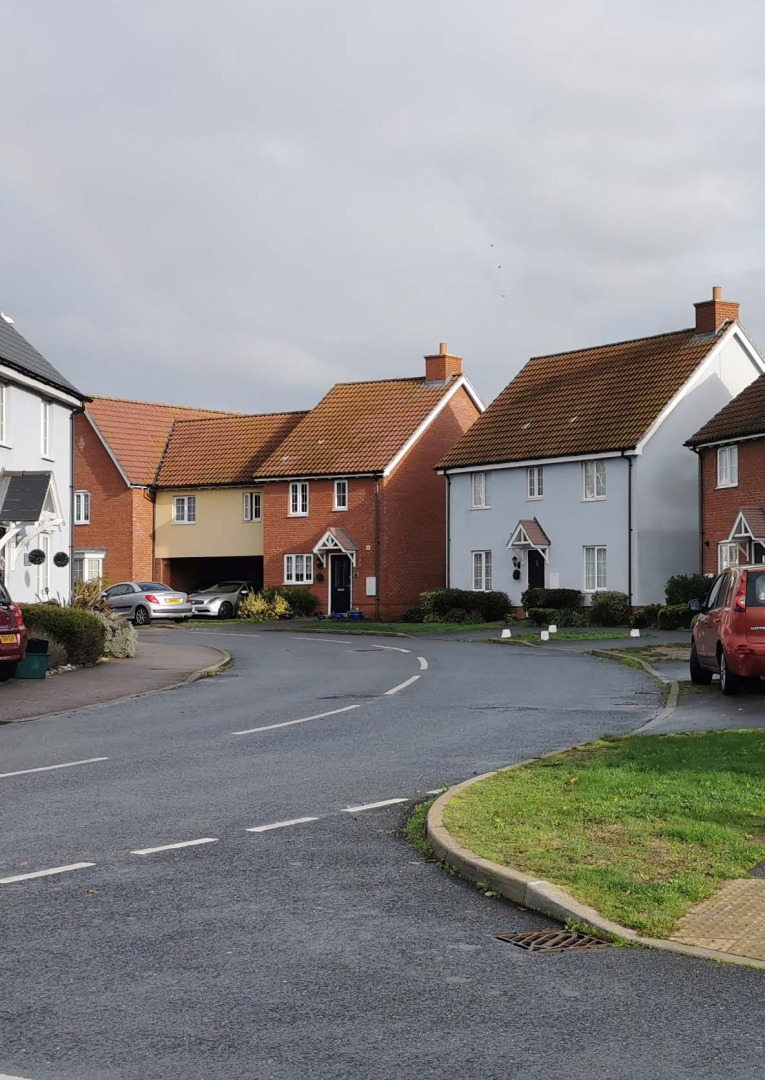
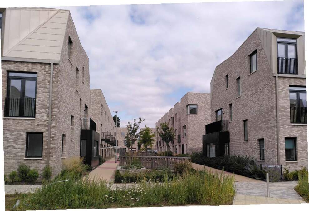
The development should respond to and reinforce locally distinctive patterns of development and landscape character which are informed by the best qualities of Clacton-on-Sea and its surrounding natural environment, the local villages, and traditional towns of Tendring and Essex, whilst not discouraging appropriate innovation.
Establishing a good understanding of character
5.5. Developments must be based on a thorough understanding of the environmental and physical characteristics of the Site and its surroundings, and an assessment of the existing local infrastructure, facilities, and character (a 'site analysis and character assessment').
5.6. The site analysis and character assessment to be prepared as part of a planning applications must include the surrounding neighbourhoods, including Little Clacton, Bocking's Elm, and Great Clacton, as well as Clacton-on-Sea Town Centre and seafront neighbourhoods, such as Marine Parade. This should include a robust assessment of development pattern, urban grain, and landscape as well as architectural characteristics of the surrounding neighbourhoods.
5.7. Much of the local context is of suburban and lower density character. To meet the vision of a sustainable development and make efficient use of the land, proposals must ensure a compact form of development with suitable development blocks, streets, buildings, and open spaces within the built-up areas, following a design-led approach. Therefore, the more urban characteristics of Clacton-on-Sea and other Essex towns are appropriate influences.
5.8. A key step will be for any development proposal to demonstrate how local influences that inform character are derived from the best qualities of those areas, whether this be valued parts of the local villages, Clacton-on-Sea, further afield in Essex, or relevant best practice developments and respond positively.
5.9. The character assessment must be brought together with reference to:
- Considerations and learning from best practice developments.
- Lessons learned from recent local developments.
- The objective to create a sustainable, healthy, and thriving new neighbourhood that allows people to choose an environment friendly and active lifestyle.
Planning applications must be supported by a site-analysis and character assessment setting out how development proposals respond to the existing site character and context to create a place of character with a strong sense of identity.
Character principles
5.10. The Site will be a significant sustainable urban extension that will create a place with character and identity that inspires existing and new communities. It is large enough to establish its own identity, with reference to the existing positive qualities of Clacton-on-Sea and its hinterland.
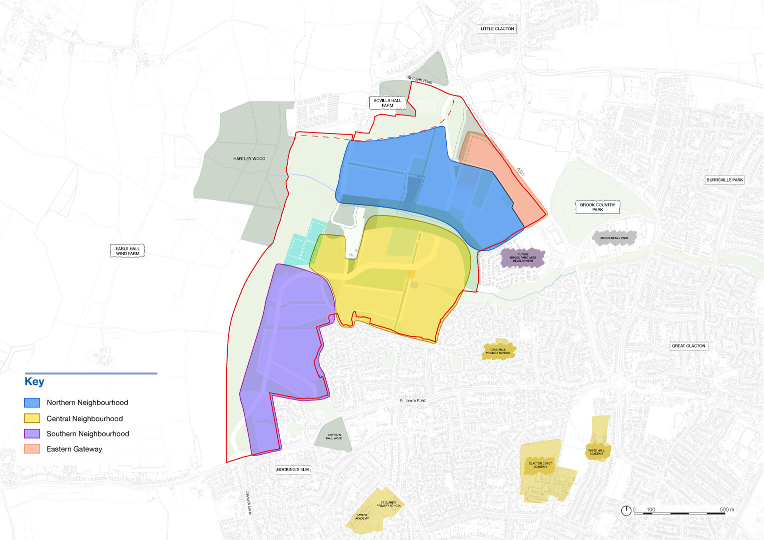
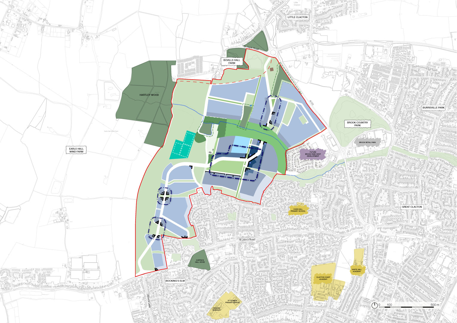
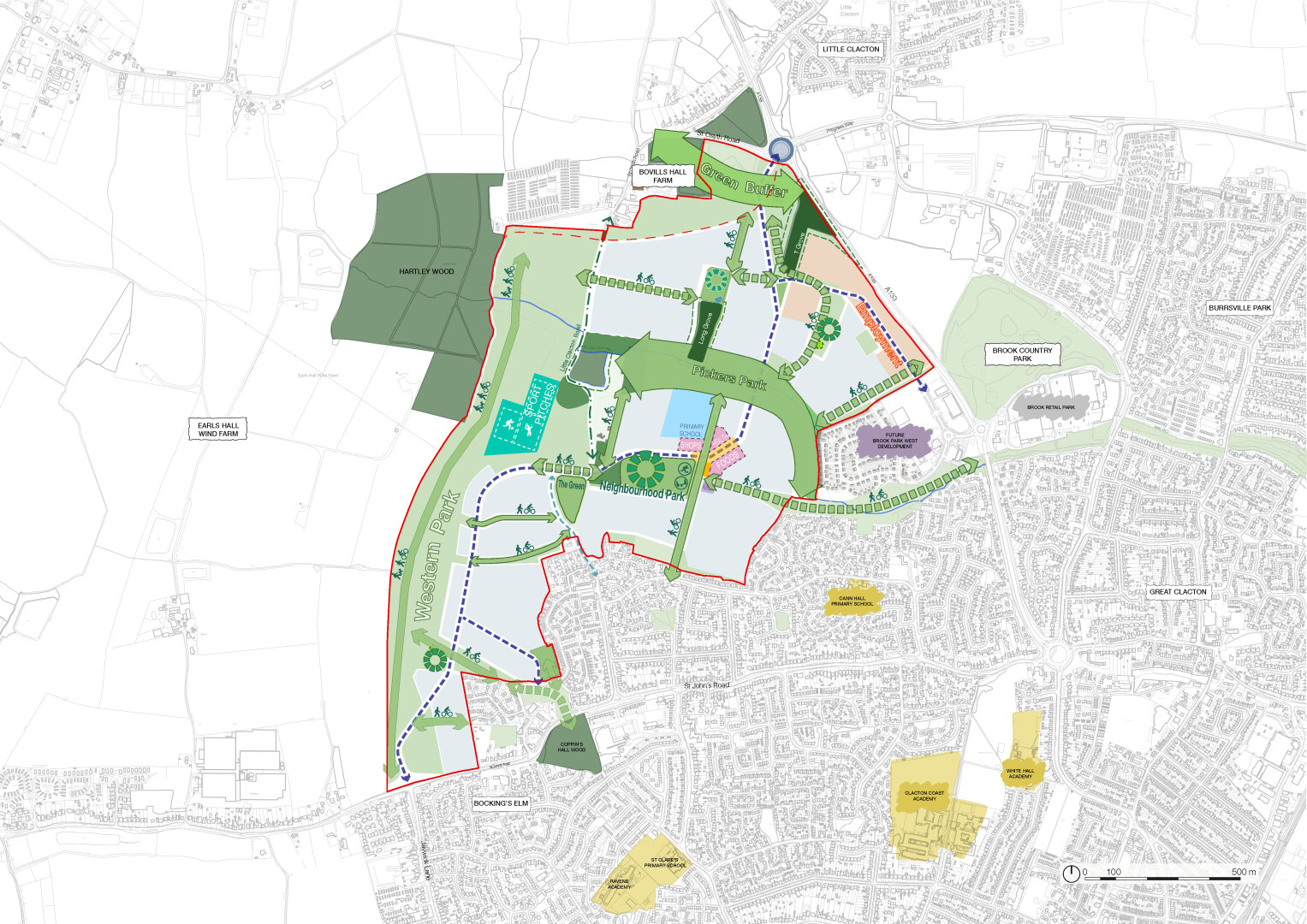
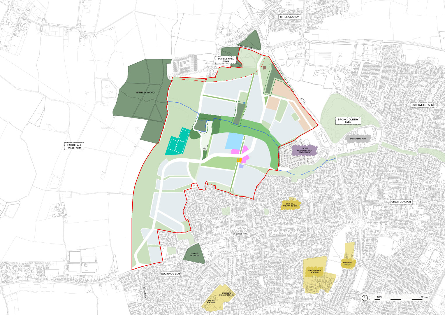
5.11. The Spatial Framework comprises four character areas which divides the Site into smaller areas to create a development which is distinctive yet harmonious, each of which will have a different character:
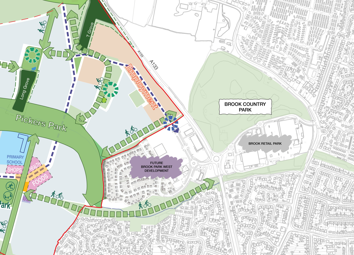
Northern character area:
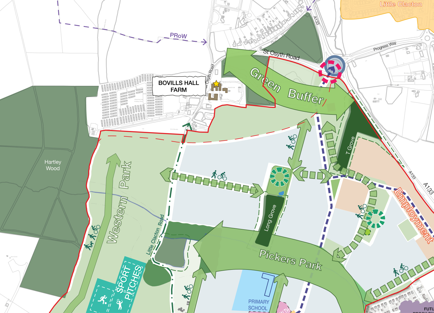
There is an opportunity to create an identity that draws characteristics from Little Clacton and heritage assets. It will provide a gateway to the Site and Clacton-on-Sea as a whole. It will be contained by Pickers Park, Western Park and a landscape corridor retaining separation from Little Clacton. It will have a formal structure, with more suburban housing forms set around a smaller green spaces and woodlands throughout, employment uses will be set alongside the A133. The development form varies between low and medium density.
Central character area:
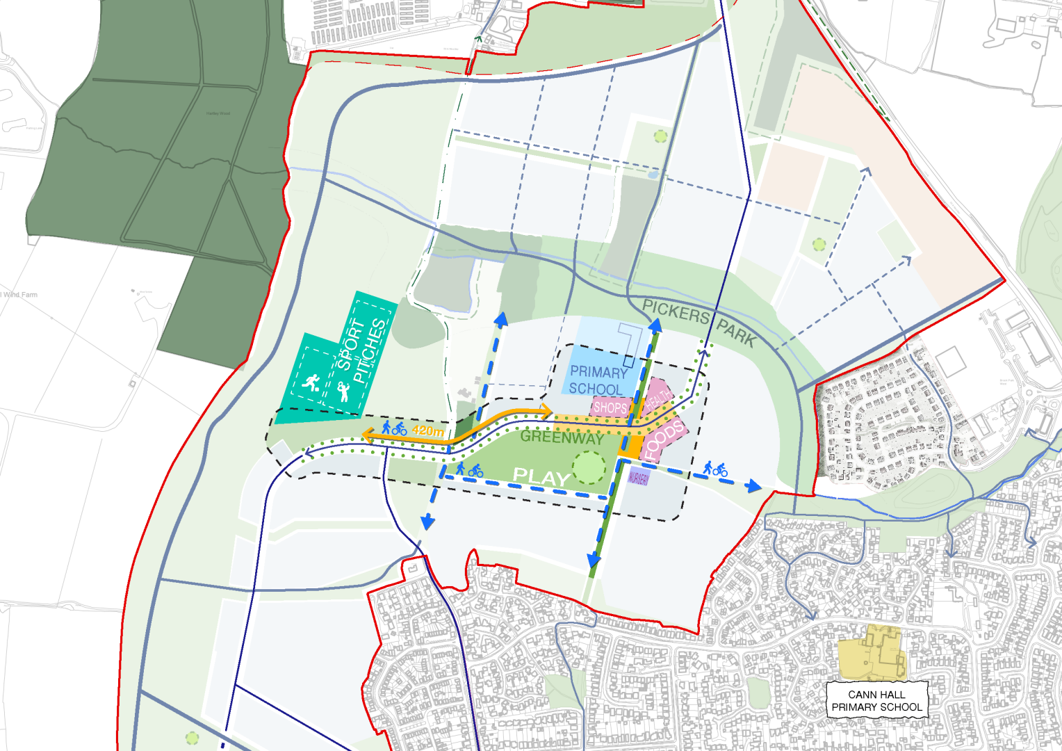
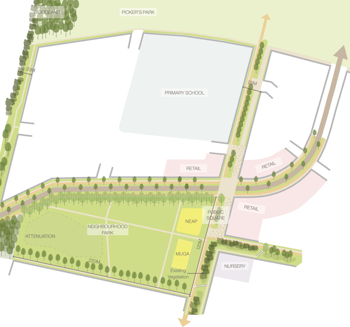
This will be the central focus of the community with a vibrant, distinct identity and a mix of uses. It will include the Neighbourhood Centre located at the intersection of existing and future routes connecting it to the wider settlement, as well as providing local amenities for the new neighbourhood. It will draw together all the community facilities such as play space, the primary school, nursery, community hub (a flexible space that could accommodate health facilities), shops and leisure uses. The Central Character area is set within the landscape bound by strategic open spaces with a number of smaller green spaces related to retained areas of existing woodland, connected together by Green Links. Its character will be defined by consistent and formal built form/edges to Green Links, Pickers Park, and the Neighbourhood Park. Housing will comprise higher density, urban family housing, including flats. Densities are medium to high with a large percentage of terrace houses.
Eastern gateway character area:
Positioned on the eastern edge of the Site, this area will act as a seamless transition between the new development and its surrounding context. Serving as a gateway, it will provide opportunities to support a diversity of employment uses, establishing a well-balanced environment that drives economic growth and enhances the district's livability. It will also serve as a sensitive transition between residential and employment uses, ensuring harmony between these functions while fostering a cohesive community character.
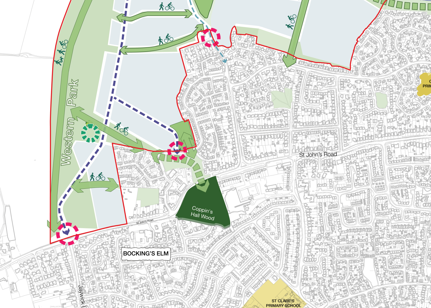
Southern character area:
This area will relate more to existing neighbourhoods to the south, with a less formal structure creating a sensitive approach into Clacton-on-Sea as a whole. The character will be a more suburban development form with clearly defined Green Links to Western Park, enabling easy access for existing residents through this new neighbourhood. It will comprise low to medium density development throughout the neighbourhood with this increasing towards the central area.
The street pattern should be distinctive and informed by the characteristics of Clacton-on-Sea’s established neighbourhoods, including:
- A regular and well-connected network of treelined streets and spaces.
- Perimeter blocks with private gardens.
- Clearly defined public spaces.
A close visual relationship should be achieved between development and new and retained landscape features and characteristics including opportunities for views towards the wider countryside to the west and heritage assets to the north and west.
Buildings should be grouped to create memorable features of townscape; support legibility, navigability and permeability; enclose spaces; and create clusters of activity. The combination of individual buildings must be illustrated in a plan, as well as three dimensions (including, where appropriate, eye level views), to ensure roof forms and architecture create a coherent whole.
Buildings should use simple, welldesigned forms that are contemporary in style but are informed by the local architectural context and the character assessment, taking into consideration ‘form-factor’ to ensure the efficiency of building shapes.
Uses and facilities that are accessible and meet the needs of the local community should be set around a Neighbourhood Park that has a positive and coherent identity that contributes towards health and well-being, inclusion, and cohesion.
Proposals will be expected to make use of distinctive townscape and landscape features to create a sense of identity and a memorable place. Specific opportunities in each character area are:
Northern character area:
- Retain existing woodlands inside the Site and integrate those hedgerows highlighted on the Spatial Framework.
- Integrate Little Clacton Road and PROW’s into the wider movement network.
- Protect the setting of heritage assets, including Bovill’s Hall and its associated pig sties and barn, to the north of the Site and Little Clacton.
- Create a gradual approach that transitions between the rural and urban environments and an attractive gateway from the northern access, with due regard to building heights and density, street frontages, and landscape features.
Central character area: - Create a Neighbourhood Park featuring inclusive destination play (including a local equipment area for play and multi-use games area) as part of the Neighbourhood Centre.
- Create a new public park along Pickers Ditch, integrating blue and green infrastructure with play, areas for quiet recreation, walking (including dog walking), and cycle routes.
- Create an important townscape node at the new and realigned junction of Little Clacton Road and the Main Street.
Eastern gateway character area: - Create a gradual transition from the eastern edge of the development, establishing an attractive gateway into the Site, with careful consideration of building heights, density, street frontages, and landscape features, while integrating existing infrastructure and uses.
- Provide up to 7 hectares for employment uses adjacent to the A133 ensuring a noise buffer to safeguard nearby residential areas is provided as well as ensuring a well planned layout that aligns with the broader character of the community.
- Implement a phased approach to employment development, with indicative parcel sizes ranging from 0.5 to 0.7 hectares for office and industrial uses.
- Establish critical mass for future phases by aligning development with the emerging retail-led mixed-use development at Brook Park West, creating a connected and thriving hub.
- Providing access to the employment land from the Main Street.
Southern character area: - Respect the setting of Duchess Farmhouse which is situated on St Johns Road close to the south-western boundary of the Site.
- Create a series of local landscape breaks marking the green corridors that separate development parcels.
- Create a gradual transition into Clacton-on- Sea along St Johns Road and an attractive gateway into the new neighbourhood with due regard to building heights and density, street frontages, and landscape features;
Built form
CORE OBJECTIVES:

Tackling climate action

Building a strong, vibrant and sustainable community

Creating a place
SPL 3 (Sustainable Design), LP 4 (Housing Layout), Essex Design Guide (2018)
The Site should be a sustainable and walkable neighbourhood that is formed around recognisable streets and spaces with their edges defined by buildings. Creating streets and spaces that are overlooked and clearly defined and will support placemaking and wayfinding, encourage social interaction, promote safety, and ultimately support a strong sense of civic pride.
Density principles
5.12. Clacton-on-Sea, as with many other towns in Essex, is made up of a variety of densities, ranging from leafy areas on the periphery with houses set in larger gardens to central areas with higher development densities. The range of densities is a key driver of character and will contribute towards sustainability objectives, as linked development forms, such as terraces and semi-detached housing, are more energy efficient, as well as create attractive and safe streets that are walkable and wheelable, as well as making more efficient use of land.
Density - The Site should be planned with density ranging from approximately 15 homes/hectare (homes/ha) to 75+ homes/ha, with due regard to character assessments, as follows:
- Higher density residential areas (min 50 - 75+ homes/ha) should be located within the Central character area and surrounding the Neighbourhood Park. This will be achieved through compact building forms and not taller buildings. Urban family housing typologies should be utilised, including a high percentage of linked and terraced forms.
- Medium density ranges (min 30 homes/ha to 50 homes/ha) will be found throughout all neighbourhoods and used to create a distinctive townscape.
- Lower density areas (up to 30 homes/ ha) will be more limited and located on the periphery of the Site, towards existing residents and the heritage assets in the north. These areas will be characterised by development that includes larger gardens and a high degree of planting to ensure that, over time, the landscape becomes a defining characteristic in these areas.
A narrow density range (i.e. 25 - 45 homes/ha) across the entire development will not be acceptable. A varied density should be achieved across the development, using a full range for each density area set out above. Where appropriate and subject to any consents, densities should be optimised.
Building height principles
5.13. Variation in height will be important in establishing a different identity in each of the character areas. Variation in height will also be important in providing nodal points and key frontages to create legibility and navigability, as well as to define key spaces and edges.
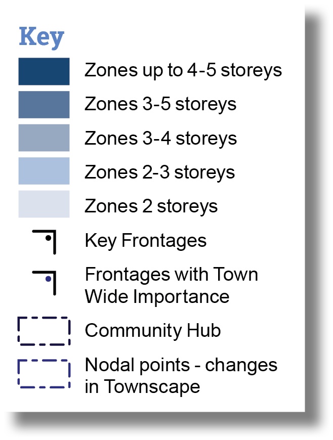
To prevent a homogeneous built environment, a range of building heights will be provided in each development parcel, creating a varied rhythm to the development allowing specific buildings to act as nodes and landmarks to aid legibility and movement across the Site.
Buildings will predominantly range between 2-4 storeys (with the opportunity for 5 storeys located centrally at key nodes) and the following Development Principles apply:
- In the Central character area, flats, mixed-use buildings, and/or specialist housing may be up to 4-5 storeys, provided the buildings are of appropriate design quality and are well located, for example fronting key streets or at key nodes.
- Building heights along the Main Street of the Central character area will vary, with taller buildings (3-5 storeys) marking nodes and junctions to aid wayfinding. Buildings that frame Pickers Park should be 3-4 storeys in height to create a well-defined edge and passive surveillance.
- Buildings in the Northern character area should be no higher than 3 storeys with predominately 2 storey buildings towards the northern boundary in response to the existing heritage assets and to ensure visual separation between the Site and Little Clacton.
- Buildings in the Southern character area should not exceed 3 storeys and must not be higher than 2 storeys adjacent to existing homes.
The positioning of taller buildings (of 4-5 storeys) will need to consider their visual impact, overlooking, orientation, overshadowing of public and private spaces, daylight and sunlight, quality of external spaces at ground level, and other microclimate considerations such as wind.
Memorable and safe street principles
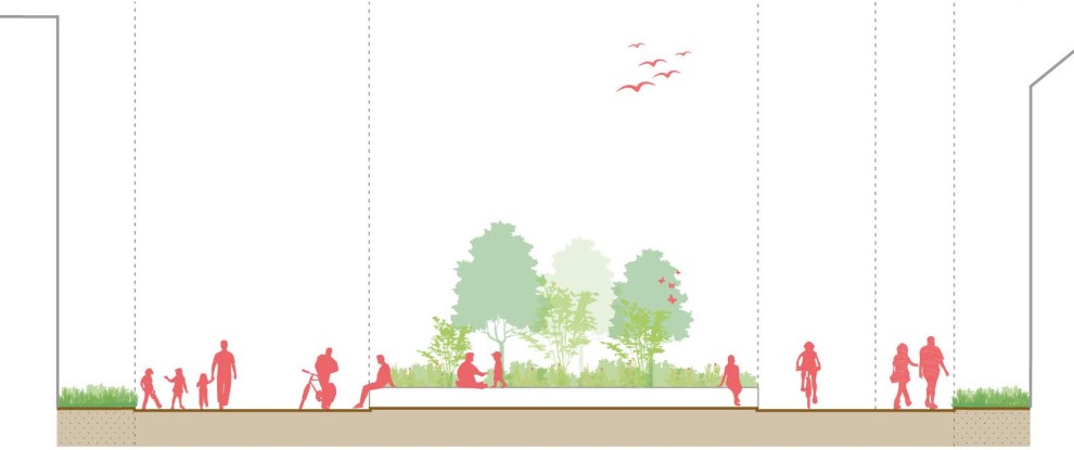
5.14. In support of climate action and healthy place-shaping, it is important to ensure that the Site is made up of 'streets' and not 'roads', providing high-quality areas of public realm that prioritise walking, wheeling, cycling, and public transport before vehicular use. This requires streets to be well defined by buildings, connected to green spaces and to feature tree lined streets with greenery to be attractive and pleasant to move along and between existing and new neighbourhoods, interact with, play in, and occupy.
5.15. Greenery, landscape, and cooling features can also contribute positively to sustainable drainage and biodiversity, and therefore climate action.
5.16. Building forms and heights must be appropriate to the width of the streets, spaces, and landscape character, used to enhance the movement hierarchy and legibility, and help to frame views. A variety of different characteristics and ratio of enclosure should be achieved as well as boundary treatments which should be cognisant of and appropriate to local vernacular.
5.17. Proposals must consider Secured by Design principles to address community concerns around safety and anti-social behaviour and this should feed into preapplication planning discussions.13
Building orientation - Buildings must be placed to create attractive streets and spaces that are well overlooked with primary entrances and habitable rooms clearly visible from the public realm, and with a clear distinction between public and private areas.
Safety - Secured by Design principles must be integrated into the development with appropriate lighting, natural surveillance, safe walking and wheeling routes, clearly defined private and public spaces, spaces that encourage positive community activities, and spaces that are easy to maintain informing the design process.
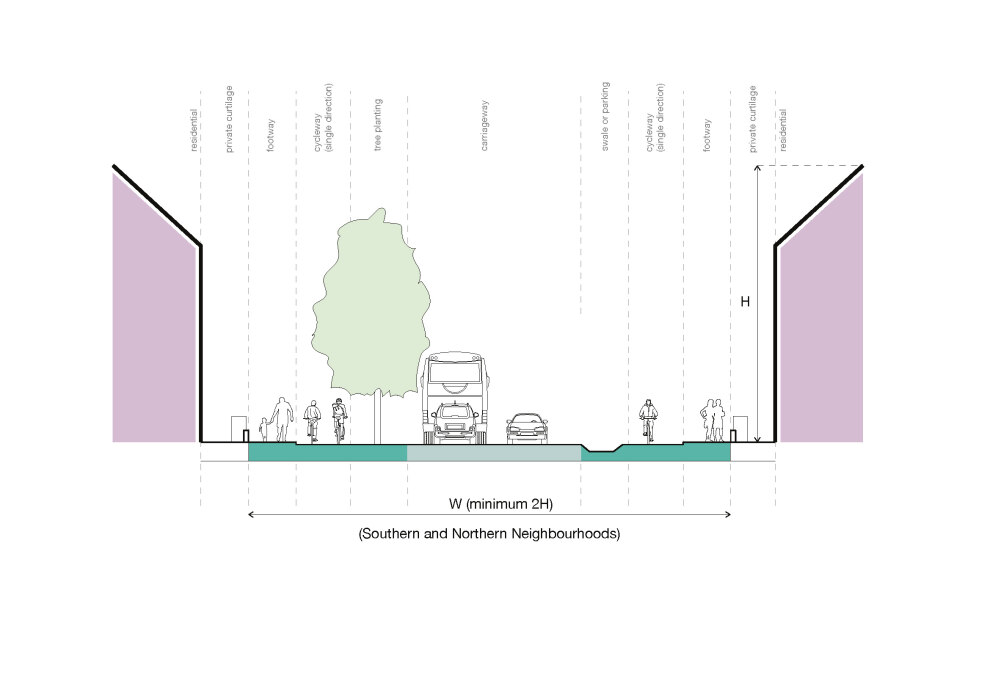
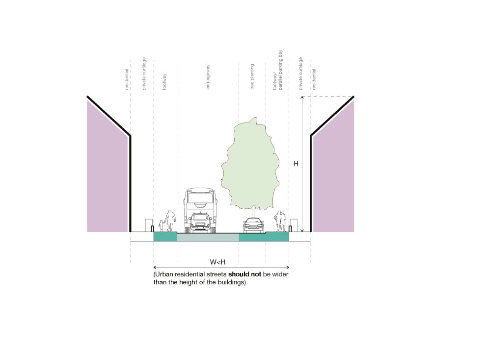
Street width - Urban residential streets should not be wider than the height of the buildings unless they include a green corridor and are of particular landscape character. In the Southern and Northern character areas, generally and with due regard to character, the width of primary and secondary street corridors should be designed to be at least twice that of the building height, incorporating space for pedestrians, cyclists, street trees and generous front gardens, rather than wider carriageways.
Frontages of new homes must define the street space with a coherent building line. This should contribute to an appropriate character that relates to the local street scene, referencing elements such as scale, building rhythm, proportion, height, materials, and colour.
Spaces at the back of streets and the front of houses must be designed to create safe, attractive, and functional environments. These spaces should be well-integrated into the overall design, with clear distinctions between private, semi-private, and public areas to ensure both usability and privacy. Natural surveillance and visibility should be prioritised to enhance safety, while avoiding hidden or underutilised areas. High-quality landscaping, lighting, and seating should be incorporated to encourage positive community interaction and enhance the space's overall appeal. Additionally, practical requirements such as bin storage and car parking must be accommodated thoughtfully, ensuring these features do not detract from the streetscape's character or functionality.
Streets should have a distinct character that reflects their usage and typology and encourages active travel, with streets clearly defined by planting including hedges, shrubs, verges and trees, and others with urban characteristics, higher degree of enclosure and smaller front gardens, such as mews streets. Trees make an important contribution to the character and quality of urban environments and can also help mitigate and adapt to climate change. Boundary treatments should be designed to contribute positively to the character of the area and to the quality of the public realm.
Movement
CORE OBJECTIVES:

Tackling climate action

Healthy place shaping

Improving movement and connectivity

Building a strong, vibrant and sustainable community
POLICY/REFERENCES:
SPL 3 (Sustainable Design), CP 1 (Sustainable Transport and Accessibility), CP 2 (Improving the Transport Network), Local Transport Note 1/20 Cycle Infrastructure Design (2020), EPOA Essex Parking Guidance 2024, ECC Mobility Hubs and Integrated Transport Hubs (2024)
The development should adopt and deliver a vision-led approach around a sustainable movement strategy designed to maximise the attractiveness of short, local trips by active and sustainable modes and encourage a modal shift away from private car use. This approach not only reduces emissions and congestion but also promotes healthier lifestyles through increased walking, cycling and wheeling, contributing to improved physical health and mental wellbeing. All modes of transport must be accommodated to create an attractive place that functions well and provides residents and employers with a range of choices as well as appropriate servicing, deliveries, and parking.
Movement principles
5.18. The development should minimise the need for travel by private car and prioritise active travel modes, such as walking, cycling and wheeling, which support healthier lifestyles and enhance physical and mental wellbeing, whilst providing necessary infrastructure for all transport modes.
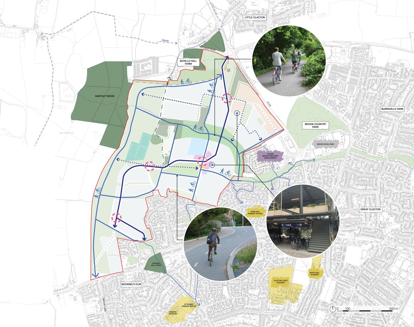
5.19. Vehicular access into the Site will be provided in four locations as a minimum. These have been identified and agreed in principle with ECC to meet the objective of creating a well-connected neighbourhood, consider the impact on the wider movement networks, seek opportunities for improvements, and create access opportunities by all necessary travel modes in a convenient and safe manner. The form of the four junctions will be agreed with ECC when planning applications are prepared. To inform this SPD, the technical work undertaken has identified the following preferred concept options.
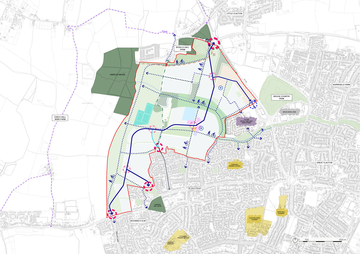
Access points must provide safe and convenient access to the Site for all users, including pedestrians and wheelers at the following locations:
- A133/Progress Way/St Osyth Road: the preferred concept for this access, is to retain a four-arm roundabout. This would entail the stopping up of St Osyth Road and the corresponding arm of the existing junction re-designed to connect to the proposed Main Street. A new connection would be made from the Main Street across to the southern end of St Osyth Road to enable existing residents to access the A133 from the new Main Street arm of the junction. Options for this are been explored. Whilst this would slightly increase journey times and travel distance for these residents, it would reduce through traffic in front of these residents' homes and open the opportunity to re-design St Osyth Road (and parts of Little Clacton Road) to create better walking and cycling routes.
- St Johns Road/Little Clacton Road Junction: changes will need to be made to the junction to improve the flow of traffic, consistent with current Manual for Streets and/or Essex Highway Design requirements.
- Legerton Drive: forms part of the road network which currently serves an existing area of residential development to the north of St John's Road and a new access is proposed on its boundary with the Site, leading directly into the Site. The detailed design of the access should demonstrate its compatibility with the wider road network and different scenarios should be explored.
- St Johns Road/Jaywick Lane: the Site includes an area of frontage on to St Johns Road in the vicinity of Jaywick Lane. The existing St Johns Road/Jaywick Lane junction takes the form of a three-arm mini roundabout. A new connection leading north into the Site alongside improvements to the existing Jaywick Lane junction will need to be provided.
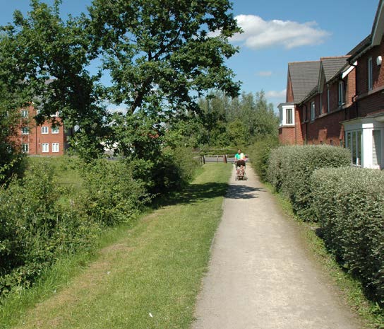
Pedestrian and cycle principles
Pedestrians - The Spatial Framework sets out the following design principles for pedestrians and wheelers that must be integrated into development proposals:
- Retain, enhance, and integrate existing PROW's.
- Create direct, convenient, and legible routes between each character area and the Neighbourhood Centre, key destinations, and open spaces.
- Have a coherent wayfinding strategy and inclusive design.
- Create connections into Clacton-on-Sea and the adjacent neighbourhoods and reinforce existing connections and desire lines such that existing residents can enjoy the new facilities and spaces, and new residents have easy access to Clacton-on-Sea, the Station, and Town Centre.
- Follow principles and guidance for cycle infrastructure in Local Transport Note 1/20 (2020), and as updated.14
- Provide pedestrian-, wheeling-, and emergency-only access to outside the school, with the exception of on-site parking for staff and visitors, deliveries, and access for grounds maintenance vehicles.
5.20. To encourage a sustainable, healthy, and equitable movement network throughout the Site, the development will put walking and wheeling at the top of the hierarchy. Development layouts should consider the needs of pedestrians first, creating a development where people are encouraged to walk and wheel on safe routes and easily find their way around and to and from the Site. Streets, routes, and spaces must be designed to create an inclusive and accessible environment that caters for everyone, including those with push chairs, the elderly, and those with physical and sensory impairments, where people are able to freely move around safely and with confidence. Design proposals should follow best practice for inclusive and accessible design set out in British Standard 83000- 2:2018, and as updated.15
Public Transport Principles
5.21. As an urban extension to Clacton-on-Sea, the transport links from the Site to the wider town are an important aspect of the sustainable transport strategy.
Public transport - The Spatial Framework sets out the following design principles for public transport that must be integrated:
- A primary and secondary street network designed to enable bus services through the development, the Neighbourhood Centre, and the employment area.
- A network of bus stops that ensures the majority of homes (i.e. a minimum of 70%) are within 400m (or less) walking distance of a bus stop.
Street hierarchy principles
5.22. The Site is a significant development that will need to accommodate different movement types and road capacities.
Street hierarchy - Development proposals should follow a clearly defined street hierarchy, including the broad street types set out above. Additional street types are acceptable, where justified, to create an interesting and varied street hierarchy that is legible, functional, and accommodates all modes of transport (prioritising walking and wheeling) as well as place qualities.
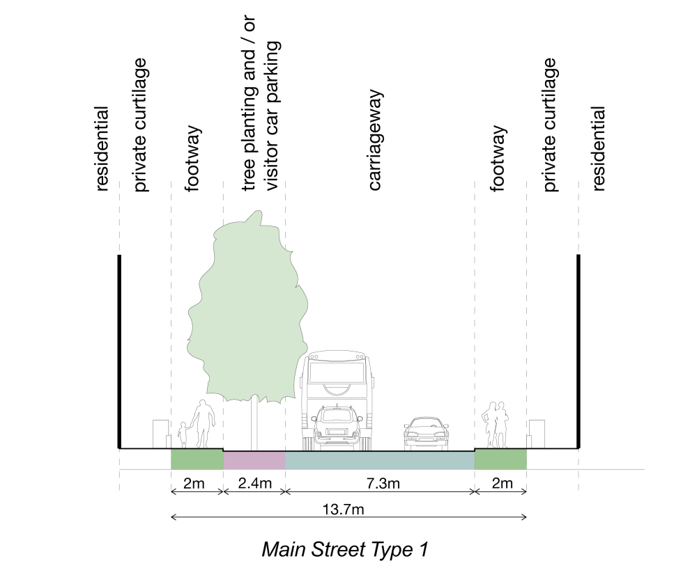
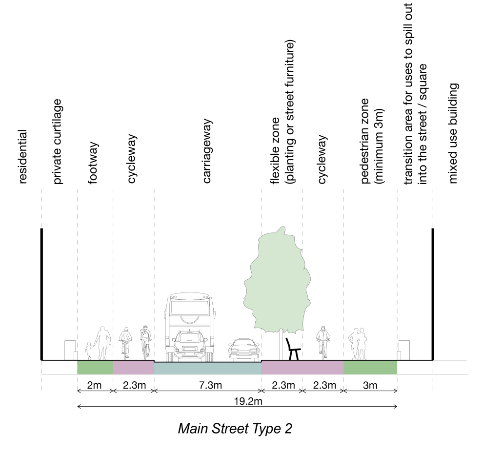
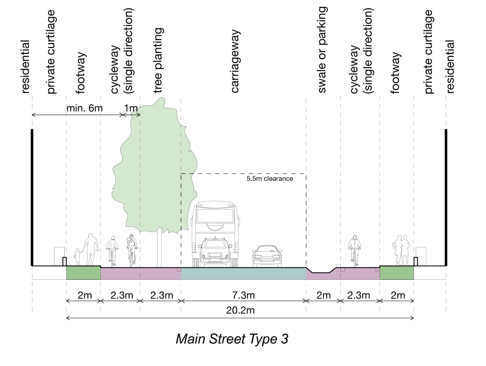
Street typologies - The Spatial Framework has been based on four overarching street types that form the principal street hierarchy of the Site: the Main Street, Secondary Streets, Tertiary Streets, and Green Links.
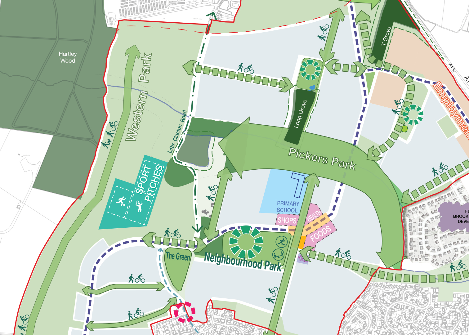
Main Street: This Main Street will link St John's Road in the south to the northern roundabout, running through the Neighbourhood Centre (as a hub of uses and activity) and across Pickers Ditch. It will be a multi-functional movement corridor for all modes of transport, include segregated wheeling lanes, bus stop infrastructure, on-street parking bays, planting, and sustainable drainage features where appropriate and suitable. The street will vary in character and function along its length and be designed to serve the development, as opposed to being an alternative to the existing main road network.
Secondary Streets: These are streets that accommodate bus routes and provide access to the employment area and new homes, accessed from the Main Street. Secondary Streets should be residential in character and must be designed with the needs of residents in mind. Despite a constant width of carriageway (min 6.75m to accommodates buses) they will also vary in character and include segregated wheeling lanes, bus stop infrastructure, on-street parking bays, planting, and sustainable drainage where appropriate and suitable, but be different from the Main Street by virtue of their narrower width and primarily residential character.
Tertiary Streets: A range of different tertiary street types will enable safe and convenient access to homes, including traditional streets with pavements either side, mews streets, or specialist play or wheeling streets. Parking for servicing needs and access for those with mobility issues will be integrated into the street layouts in a manner which reflects the wider movement hierarchy. These streets will be designed to create a safe environment for children and adults. Healthy Street principles should be applied.
Green Links: These are car free routes along landscape corridors to enable safe and convenient walking and wheeling routes thorough the new character areas and to key destinations, including the primary school, Neighbourhood Centre, and employment area.
Speed limits will be appropriate for the nature of the street (i.e. Main Street, Secondary Streets, Tertiary Streets, and Green Links), and this is likely to differ along the length of the street due to the different frontage development types.
Cycle and car parking principles.
5.23. Cycle and car parking should be well integrated and flexible, to accommodate potential changes in travel patterns, car ownership, and lifestyle. Parking should be provided in accordance with Essex Planning Officers Association’s Essex Parking Guidance 2024, and as updated.16
Cycle parking must be provided in line with parking standards set out in policy as a minimum and seek to maximise cycle parking spaces where possible.
Cycle parking must be safe, accessible, and conveniently located to promote all forms cycling and encourage its use, with the inclusion of facilities for electric bicycles and larger non-standard cycles such as adapted bicycles, cargo bicycles, and bicycles with trailers.
Visitor cycle parking should be provided in regular intervals adjacent to the main public open spaces, within the Neighbourhood Centre, adjacent to the school and playing fields, and within the employment area.
Car parking – A wide range of car parking options should be provided, including: on-street parking and shared parking squares in close proximity to homes, on-plot and integral parking areas with reduced parking provision, or, depending on further design development, pockets of car free development and a reduction in parking over time. Applied car parking standards and the specific approach to car parking will be further refined through Design Codes and defined at the detailed design stage, to ensure latest best practice and technologies are being accommodated (such as electric vehicle charging). This will include specific consideration of needs for powered two-wheeler parking and how short-term servicing space for delivery vehicles and emergency vehicles can be integrated into parking design and access arrangements.
Within the Neighbourhood Centre, parking areas should be shared between uses to minimise land take and avoid individual uses being set within surface car parking areas.
Blue badge parking and parent/ child parking must be in close proximity to facilities and services. Traffic Regulation Orders should secure the spaces in perpetuity.
Mobility hub principles
5.24. A mobility hub is a strategic location that offers a variety of public, shared, and active transportation options and community services. They are safe and connected places, and designed to enhance connectivity, reduce car dependency, and support inclusive, lowcarbon travel.
5.25. As part of the sustainable transport strategy for the Site, mobility hubs can provide flexible on demand transport options for residents travelling within the development and to the wider area.
5.26. Mobility hubs offer efficient connectivity by integrating multiple transportation modes and reducing reliance on private vehicles. They promote active transportation, improving public health and cutting carbon emissions and can become vibrant community hubs, fostering accessibility and sustainability.
5.27. Mobility hubs combine the consideration of both ‘mobility’ and ‘place’, with a range of essential, desirable, and optional features depending on the typology of hub.
- Mobility: a hub provides options and convenient interchange between different transportation modes including: public modes, such as bus services, community, and on-demand transport; shared modes and micro-mobility such as e-scooters, bike share facilities, cargo bike hire, and car clubs; and, active modes such as walking, cycling, and wheeling.
- Place: a range of facilities and services can be provided such as cycle parking and repair, micro-mobility docking stations and charging, bus shelter and seating, electric vehicle charging points, as well as various amenities such as toilets, Wi-Fi, phone charging, local information, parcel lockers, and refreshments.
5.28. Further information to support the design and implementation of mobility hubs, including key principles and considerations for different typologies, is set out in Essex County Council’s Mobility Hubs and Integrated Transport Halts Implementation Guide (2024), and as updated.17
Mobility hubs - It is envisaged that one central mobility hub will be located within the Neighbourhood Centre close to the bus stops and two smaller community mobility hubs located in the Northern and Southern character areas. Planning applications will need to demonstrate how they provide or contribute to mobility hubs, including what they encompass.
Nature
CORE OBJECTIVES:

Tackling climate action

Healthy place shaping

Protecting and enhancing natural assets
Building a strong, vibrant and sustainable community

Creating a place
POLICY/REFERENCES:
PPL 4 (Biodiversity and Geodiversity, PPL 6 (Strategic Green Gaps), Natural England Green Infrastructure Framework (2023), Building with Nature Green Infrastructure Standards, ECC Green Infrastructure Strategy, ECC Local Nature Recovery Strategy, ECC Sustainable Drainage Systems Design Guide (2020)
Landscape will be a defining feature of the Site that will provide a wide range of public spaces for the enjoyment and wellbeing of residents. These will be multifunctional spaces with important roles in creating local character, landscape and ecological networks, sustainable drainage, managing local micro-climate, and walking, wheeling and cycling routes. Building with Nature (BwN) principles will be actively incorporated into the creation of spaces where new residents will want to play, live, and work with the aspiration of achieving a BwN Design Award.
Landscape character principles
5.29. The Site landscape principles aim to protect and enhance existing landscape features whilst creating additional natural and semi-natural greenspaces, building off the local landscape character assessment. Key features such as Pickers Ditch, T Grove, and Long Grove are to be retained and/or enhanced to create the structure for the landscaping principles.
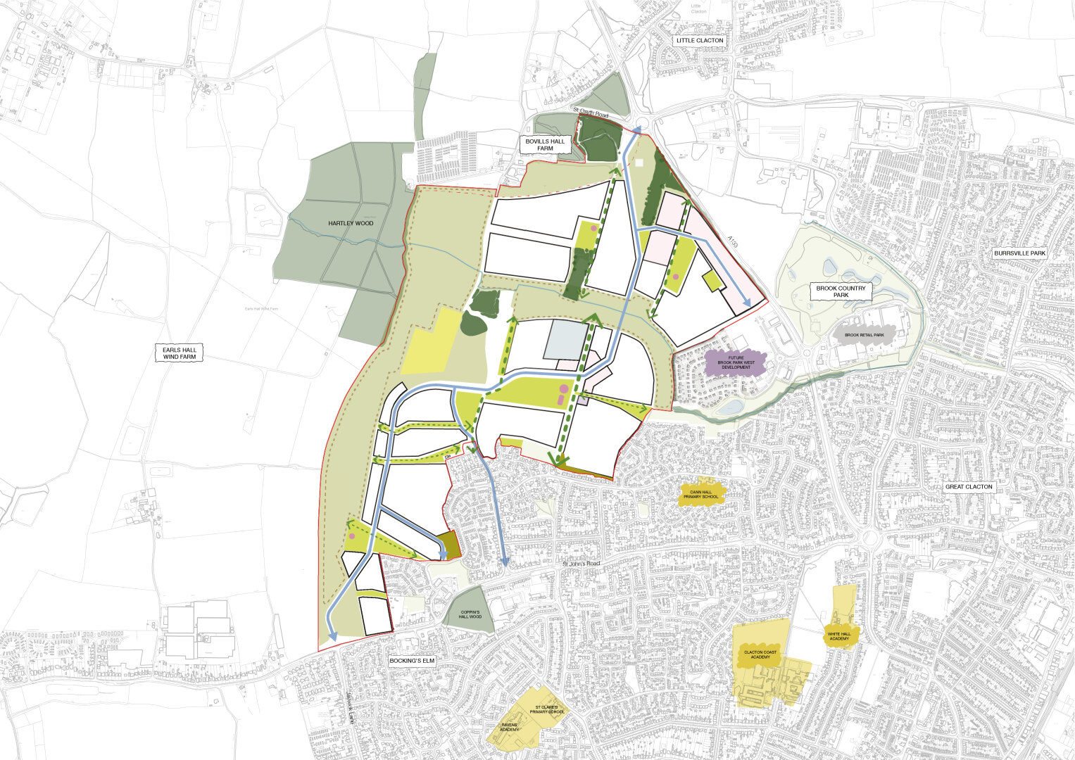
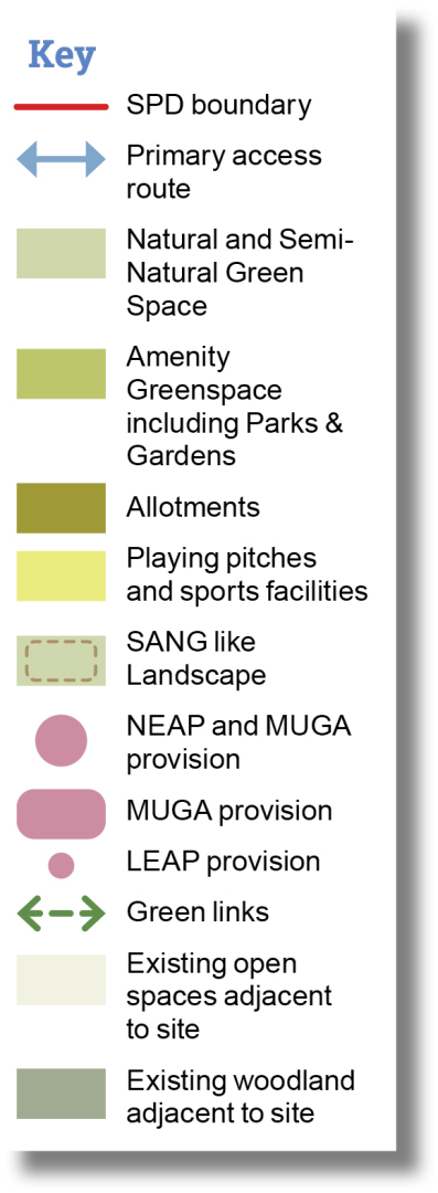
5.30. The overarching landscape strategy has defined the following spaces as illustrated in the Spatial Framework.
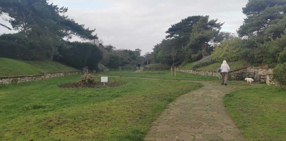
- Pickers Park: An open landscape reflecting the surrounding inland coastal character, grasslands and marshlands. The design will incorporate the existing Pickers Ditch (and associated flood zone). New marshland will be provided around the Ditch expanding this landscape habitat. Large amenity grass spaces will be included, providing flexible space for activity and informal recreation. Pickers Park will include walking routes and provide a semi-natural landscape for dog walking.
- Landscape Sustainable Drainage Systems (SuDS) features should be located outside of the flood zone, providing increased drainage capacity whilst creating interesting and varied grassland habitats. Active uses can include equipped and natural play areas, as well as active travel routes including a north/south cycle route.
- Western Park: Will provide a strategic large semi-natural landscape set away from built development and provide space for natural landscapes and habitats to be created as well as existing ones to be retained and enhanced. It will form part of the dark corridor to promote ecology so it will not have lighting.
- In daylight hours, the accessible natural green space will be for the local community to use, mitigating the pressure on other green spaces and natural landscapes in the area. The Western Park will include the playing pitches and sports pavilion, as well as a mix of surfaced and non-surfaced paths employing natural materials over relatively flat accessible terrain. These routes will provide recreation for walkers, wheelers, and dog walkers. Seating at regular intervals and dog bins should be provided alongside the route.
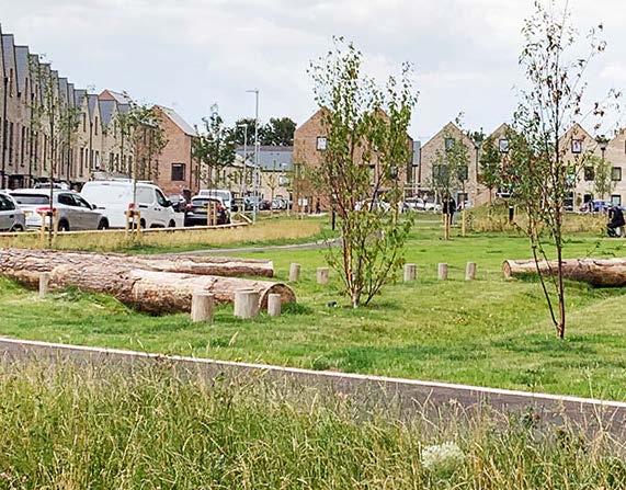
- Neighbourhood Park: will be the main formal park in the Site. It will be situated close to the school, retail, and community facilities. Its location should be easily accessible by all residents and the adjoining existing neighbourhoods within Clacton-on-Sea. It will provide the destination play (including a local equipment area for play and multi-use games area), along with areas for recreation, natural landscape, and rainwater attenuation.
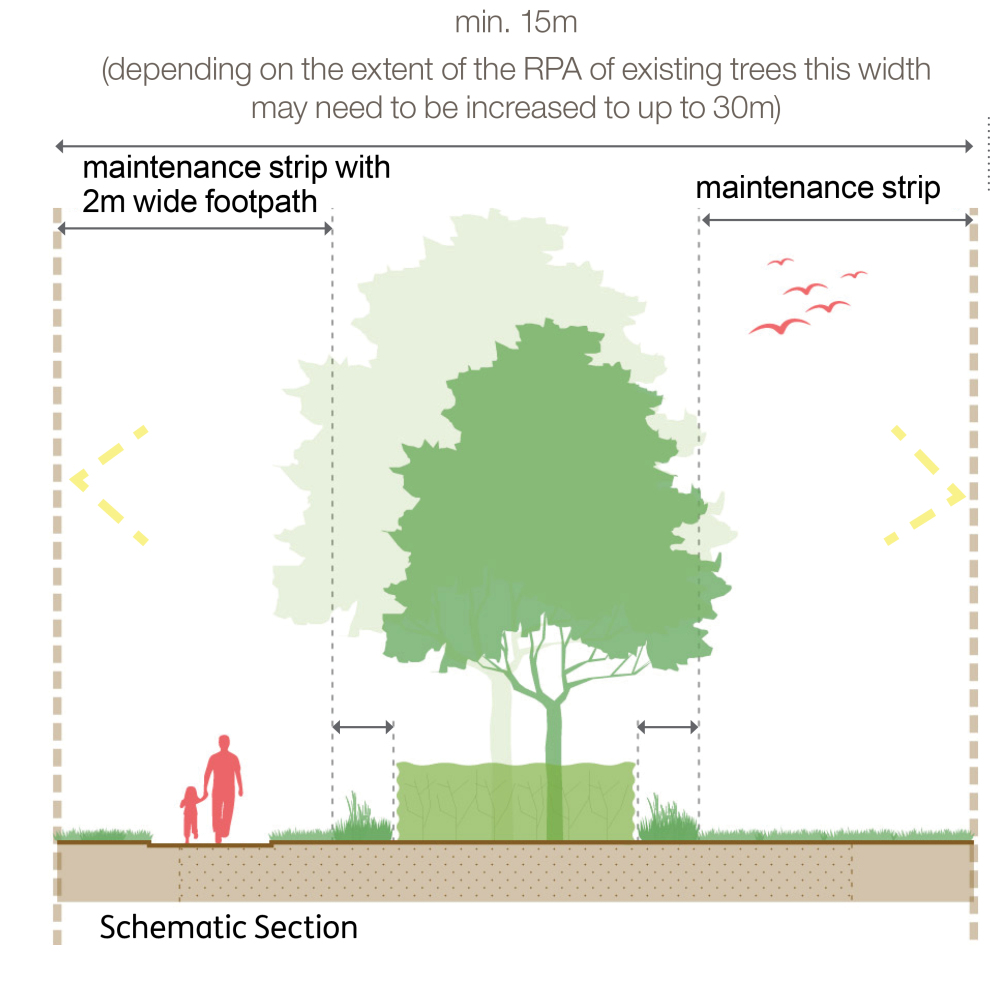
Landscape – Retain existing landscape features where possible. Existing trees and hedgerows should be integrated into street scenes, new public spaces, and gardens.
Enhance and create new landscape with due regard to local landscape character, including protecting and increasing habitats for locally significant/rare flora & fauna. The landscape should complement the architecture and create a desirable setting for new homes and other buildings. It should be varied and designed with specific activity and biodiversity in mind. Spaces with pure lawns are discouraged unless serving a particular purpose such as kickabout or informal play.
Landscape design should also consider long-term climate resilience, incorporating shading and cooling to mitigate the urban heat island effect. Plant species should be selected based on their ability to thrive in changing climate conditions, prioritising drought tolerance, tree canopy cover, and biodiversity to ensure sustainability and climate adaptation.
Connected, multifunctional green and blue network principles
5.31. The landscape strategy has been developed based on providing a multifunctional and integrated green and blue network. The Site will make adequate provision for drainage and should include SuDS as a means of reducing flood risk, improving water quality, enhancing the green and blue infrastructure network, providing amenity, and biodiversity benefits.
5.32. The green and blue networks will align with the movement networks, ensuring that corridors for movement, play, SuDS, and biodiversity are integrated and run alongside each other. This alignment creates a seamless and efficient system where walking, wheeling, and recreational routes coexist with SuDS features and green spaces, enhancing both ecological and community connectivity.
5.33. Anglian Water is envisaged to adopt swales, basins, and other SuDS features, which should be designed to maximise biodiversity and recreational benefits. The implementation and maintenance of these features within the development also contributes to more resilience in the long term to a changing climate.
Connected landscape – Development should create a connected biodiversity and landscape network that provides an organising structure and connections both physically and visually moving through Pickers Ditch to the centre of the Site and the surrounding area. One vehicular crossing point across Pickers Ditch should be provided within the Central character area to create a connected and resilient street network. If required, sufficient flood plain compensation will be allowed. Several other footway/wheeling crossings of Pickers Ditch are proposed but are not envisaged to be flood resilient.
Strategic interconnected ponds and swales will comprise the SuDS drainage strategy. Runoff will be attenuated in these SuDS features before it is discharged at a restricted rate into Pickers Ditch and to the south of the Site, following ECC’s Sustainable Drainage Systems Design Guide (2020), and as updated.18 Onplot storage should also be proposed for the separate development parcels, in the form of opportunities for water reuse or capture, permeable paving, rain gardens, and further swales with targets included at planning application stage.
Ecology and biodiversity principles
5.34. Ecology enhancement and any necessary mitigation must be integrated into the landscape strategy from the outset and following the principles defined in the Spatial Framework and with due regard to the local nature recovery strategy.
5.35. As identified in Section 3 Assessment there are limited ecological constraints to the development of the Site. The T Grove and Long Grove woodlands qualify as a Section 41 priority habitat. Great Crested Newts (GCN) are present on the Site, mostly in the far north and barbastelle bats have been identified commuting in the Site. Mitigation for wintering birds (golden plover and lapwing) is also likely to be required. All planning applications will need to ensure up to date ecology information, and any necessary mitigation is provided. These requirements should align with the landscape and biodiversity principles N4 and N5, ensuring that development contributes positively to ecological resilience and habitat connectivity.
Habitat creation - Create habitats and mitigate impacts on protected species by:
- Creating dark corridors in the following locations to ensure ecological habitats remain connected:
- Along the western Site boundary with habitats known to be used by barbastelle bats, the rarest and most light sensitive species recorded.
- Along the northern Site boundary which links smaller areas of woodland within and adjacent to the Site.
- A less light sensitive corridor along Pickers Ditch where no Barbastelle bats have been recorded using the Ditch habitats, and more flexibility exists in terms of light levels compared to the western and northern corridors. This corridor will be suitable to serve and mitigate impacts on otters.
- Ensuring appropriate mitigation of impact on Great Crested Newt (GCN) through the enhancement of nearby habitats within open spaces to create additional ponds and a structurally diverse habitat (such as longer grass, scrub, and woodland). Connecting these new and existing ponds and installing amphibian underpasses where needed underneath the Main Street and amphibian friendly drainage features on roads within development plots where these fall within 250m of confirmed GCN ponds.
- Retaining the south-west corner of the Site as appropriately designed open space as illustrated on the Spatial Framework to avoid increasing impacts on potential wintering birds within the vicinity.
- Retaining trees where possible.
- Providing opportunities for enhancing existing species through the provision and design of the development such as bird and bat boxes and edible landscapes.
- Ensuring management regimes are in place as necessary to ensure medium- and longterm ecological benefits.
Accessible greenspace principles
5.36. The Spatial Framework provides approximately 40 hectares of semi natural landscape reflective of the surrounding landscape context of inland coastal character, grasslands, and marshlands. This should enable new and nearby existing residents to enjoy nature near their homes and thereby relieve pressure on sensitive landscapes within the region. The landscape provides opportunity for connected walks, play and recreation.
Accessible greenspace will be delivered, with significant areas consisting of the Western Park and Pickers Park, including the delivery of:
- Safe circular walking and running routes between 1-3km in length and including a chain of routes of a minimum of 2.3km.
- Dog walking routes including a dog activity trail.
- Informal cycle paths.
- Area for informal recreation.
- Visual sensitive signage and benches.
- A variety of habitats.
Public spaces
CORE OBJECTIVES:

Healthy place shaping

Protecting and enhancing natural assets

Building a strong, vibrant and sustainable community
POLICY/REFERENCES:
SPL 3 (Sustainable Design), Essex Design Guide (2018)
The Site will provide outdoor amenity for everyone by putting health, wellbeing, and accessibility as a high priority in its public space provision. The principles for the new facilities should not just apply to those moving into the new neighbourhood but also those currently living near the Site in Clacton-on-Sea.
Public space principles
5.37. The required typology and quantities of open spaces within the Spatial Framework have been designed to serve existing nearby and new residents, as well as meeting the requirements set out in the Development Plan and current guidance.
5.38. The quantity of open space should be based on an average household of 2.4 people. The requirement from TLPP2 Policy HP5 is to provide a minimum 10% of the gross Site area as open space and the Spatial Framework illustrates around 40% of open space, to accommodate accessible open space and biodiversity net gain requirements, as well as creating a new neighbourhood integrating with nature.
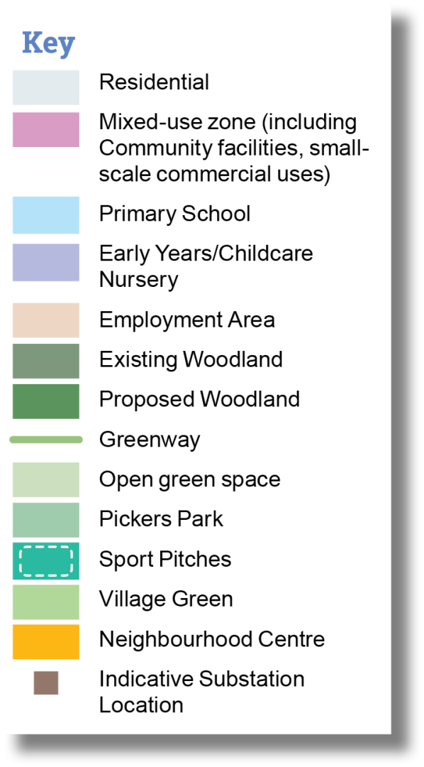
Public spaces – Provision of public space will meet the quantum and accessibility requirements as outlined by the Development Plan and the Spatial Framework.
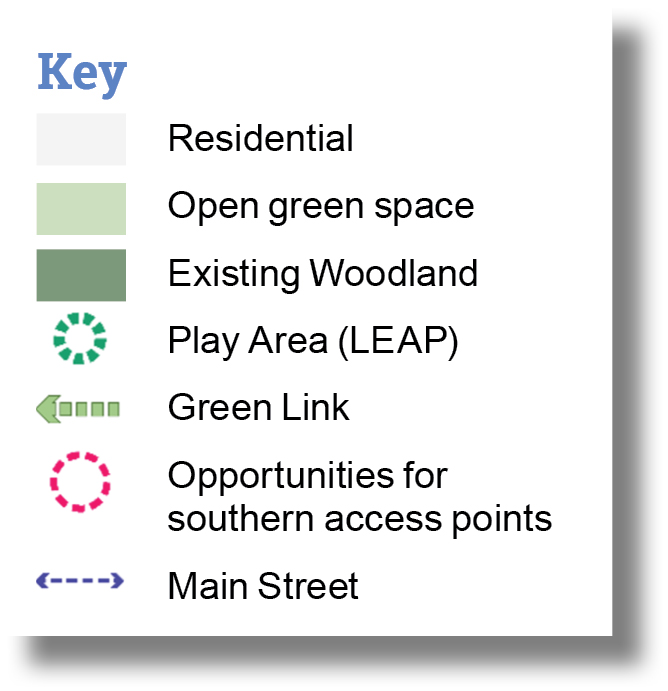
Play areas must be designed to be safe, inclusive, and accommodate a range of age groups. They must be appropriate to their location and character of the open space and incorporate opportunities for natural play. The following areas must be provided as illustrated on the Spatial Framework:
- 1x Neighbourhood Equipment Areas for Play (NEAP) (1,000sqm) in the Central Neighbourhood.
- 3x Local Equipment Areas for Play (LEAP) (400sqm each), one in each of the Northern, Central and Southern Neighbourhoods.
- 1x Multi-Use Games Area (MUGA) (20x40m, 800sqm) in the Central Neighbourhood.
Play areas should be provided in the form of destination play areas and not separate smaller play areas distributed throughout the development.
Public spaces will be designed to be safe, inclusive, and should integrate activities and facilities which meet the requirements of those with specific needs.
5.39. As identified in the landscape character principles, the Spatial Framework identifies the following strategic public open spaces all of which should be designed to be safe and accessible:
- Green Links: A network of Green Links to provide an organising structure and vehicular free connections for pedestrians and cyclists through the Site. These should be a combination of more formal character along the key routes south to the Neighbourhood Centre and east to the employment area, with a more natural character for other routes, incorporating 'play on the way' where appropriate, be well-lit and safe, and include cycle parking.
- Western Playing Fields: 2x adult grass pitches and 1x junior grass pitch/youth pitch will be located on the western edge of the Site within comfortable walking distance of the Neighbourhood Centre and existing communities to the south. They should be carefully integrated into the wider landscape so as not to compromise the wider ecology role of the Western Open Space.
- Community Square: This should be an area of flexible public realm, located outside the retail and community facilities. It should provide opportunities for adjacent uses to spill out into the space and could be used for temporary markets, community events, and festivals.
Uses
CORE OBJECTIVES:

Tackling climate action

Meeting current and future housing needs

Building a strong, vibrant and sustainable community
POLICY/REFERENCES:
LP 1 (Housing Supply), LP 2 (Housing Choice), LP 5 (Affordable Housing), HP 2 (Community Facilities), PP 1 (New Retail Development), PP 3 (Village and Neighbourhood Centres), PP 6 (Employment Sites), PP 12 (Improving Education and Skills), ECC Developers' Guide to Infrastructure Contributions (2024), Essex School Organisation Service Garden Communities and Planning School Places, Essex Place Services School Design Principles (2025)
Housing principles
5.40. The Site will provide a range of housing that is responsive to current and future housing needs. The Spatial Framework enables a range of housing types and sizes to provide a diverse and mixed community where social interaction will be encouraged between different ages and incomes to create a sustainable and vibrant place.
5.41. The quantum, tenure, and mix of housing will provide choice and meet current and future need in line with Policies LPS2 2, LPS2 5 and SAMU2. The detailed mix of housing types for each planning application will be determined on a case-by-case basis, informed by prevailing need, including that identified in TDC's latest Strategic Housing Market Assessment. All housing will be designed 'tenure blind' and affordable housing will be secured as part of an appropriate legal agreement.
Development will provide a variety of housing tenure, types, and sizes to allow for a mix of residents, including different ages and abilities.
Neighbourhood Centre principles
5.42. The Neighbourhood Centre should accommodate small-scale retail development to serve the day-to-day needs of residents in the local community and not divert economic activity from Clacton-on-Sea Town Centre.
The Neighbourhood Centre will be located within easy reach of the new residents as well as the community to the south of the Site, providing them with a choice of additional services and meeting day-to-day needs. It will contain the following uses:
- Community facilities in the shape of one larger Centre within the Neighbourhood Centre and one smaller space in the form of a sports pavilion adjacent to the playing fields.
- A cluster of small-scale commercial uses with the opportunity to accommodate café, restaurant, retail and leisure uses as well as affordable workspace for offices, studios, and workshops.
- A primary school with two-form entry with a 56-place nursery (2.1 hectare site).
- A standalone 56 place early years and childcare nursery (0.13 hectare site). - A community hub consisting of a flexible space that can accommodate health facilities.
The Neighbourhood Centre must be designed as a mixed-use environment with urban characteristics. The nonresidential uses should be clustered around a Community Square providing an opportunity for temporary uses, such as markets, events, and community events.
Education use principles
5.43. The redevelopment of the Site will include a new primary school that will be delivered in line with relevant ECC guidance, including ECC Developers' Guide to Infrastructure Contributions19, Essex School Organisation Service's Garden Communities and Planning School Places20, and Essex Place Services School Design Principles21, and as updated. The area identified in the Spatial Framework meets the requirements of the guidance and ensures that the school has a traffic-free environment around the pedestrian entrances with the School Square connecting to the Green Link and Pickers Park, in close proximity to the Neighbourhood Centre, whilst also providing separate vehicular access for staff, emergency vehicles, and maintenance vehicles. This provides the opportunity to support a vibrant community hub within the central area of the neighbourhood.
5.44. The developer(s), TDC, and ECC will liaise and collaborate with one another to secure a high-quality education facility.
5.45. Developer(s) will be required to submit an Education Land Compliance Study report which demonstrates the land is suitable for school use, sharing this with ECC as a draft prior to submission. This report should be a self-contained document.
Employment land principles
5.46. Given Clacton-on-Sea is an area of severe multiple deprivation, and that employment income are wider determinants of health, it is important to make the most of the opportunity at the Site to improve outcomes for existing residents and avoid exacerbating existing challenges. This will be achieved through the provision of up to 7 hectares of land within the Site for employment uses to generate on-site jobs and balance economic growth with housing growth.
5.47. The employment land is in addition to small-scale commercial uses in the Neighbourhood Centre that will also contribute to on-site job creation and support the day-to-day needs of existing and new residents.
5.48. In line with the principles set out in the LPS2, the Site will support and diversify the economy whilst maintaining a balance between homes and jobs. The priority will be to provide sufficient flexibility in land allocation to give businesses an opportunity to stay in the local area as they grow from start-ups to mature companies, helping to drive the local economy. To achieve this, the right amount and type of employment land should be provided that reflects market demand.
5.49. Accordingly, the provision of employment land will be reviewed and delivered as the development progresses to ensure it is responsive to market signals and flexibility is retained.
5.50. There will also be additional job creation in retail and service sectors as well as community, leisure, and education.
5.51. There will be a range of buildings provided that will facilitate home working and business start-up as well as flexibility of use (e.g. office and/or residential). Adaptable buildings on primary routes will also enable commercial uses over time.
5.52. Initial serviced employment land of 0.5-0.7 hectares could be provided and/ or an initial phase of employment could be located adjacent to Brook Park West, an existing commercial centre with established infrastructure, that could be extended northwards to serve the Site. This location also has the prominence and accessibility of the adjacent A133. It would be accessed from a link to the Main Street.
Employment land will be located within the proximity of existing infrastructure and adjacent to the A133 corridor. It should be designed to be a high-quality, pedestrian and cycle friendly environment.
The employment land will remain flexible and responsive to market signals and will comprise uses across the following planning use classes as appropriate:
- B2 General Industrial
- B8 Storage and Distribution
- E(g)(i) Offices
- E(g)(ii) Research and Development
- E(g)(iii) Industrial Processes
TDC will monitor employment market demand to inform the future typologies and quantum of employment development. Future planning applications on land identified for employment should be accompanied by an employment study and linked viability assessment, this will include how employment delivery is linked to housing delivery. The provision of future employment and impact will be assessed by TDC.
Homes and buildings
CORE OBJECTIVES:

Tackling climate action

Meeting current and future housing needs

Building a strong, vibrant and sustainable community
POLICY/REFERENCES:
SPL 3 (Sustainable Design), LP 3 (Housing Density and Standards), PPL 10 (Renewable Energy Generation and Energy Efficient Measures), Essex Design Guide (2018), ECC Essex Parking Design Guidance (2024)
TDC declared a climate emergency on 6 August 2019 and has set out its plans to become net zero carbon by 2050.
High quality energy efficient homes and buildings will be designed to promote the health and wellbeing of the future community and enable sustainable lifestyles. Design Codes will be a planning application requirement to secure key design principles, character, and quality throughout the development.
5.53. Design Codes will be an important part of delivering and maintaining design quality through the delivery of the development. Design Codes will be required with full planning applications or ahead of reserved matters applications pursuant to any outline planning permission.
Design Code(s) must follow the high-level principles set out in this SPD and will provide further detail to secure design quality and specify the following:
- How the design and appearance of buildings and spaces will be characterful and high quality.
- The requirement for meeting Nationally Described Space Standards; prioritising dual aspect homes, and ensuring provision of adequate private and communal open spaces including gardens and balconies.
- Guidance on incorporating passive housing design features to promote energy efficiency, sustainability, and comfort.
- Guidance on the integration of storage, waste collection, servicing, and utilities.
- Guidance on dedicated, safe and secure cycle parking for individual homes, including electric bicycles and larger non-standard bicycles, following ECC Essex Parking Guidance 2024, and as updated.
- Guidance on water saving measures as well as rainwater capture and reuse.
Residential design and layouts should provide flexible and adaptable spaces to support homeworking. For example:
- In larger properties, a dedicated study may be provided, or bedrooms and garages may be designed to facilitate conversion.
- In smaller properties, niches or partitions, landings or bedrooms could provide quiet space away from other household activities.
Environmental quality principles
5.54. The qualities of the environment, including microclimate, flicker impact from nearby wind turbines, noise, and air pollution is an important factor to delivering health and wellbeing for future residents.
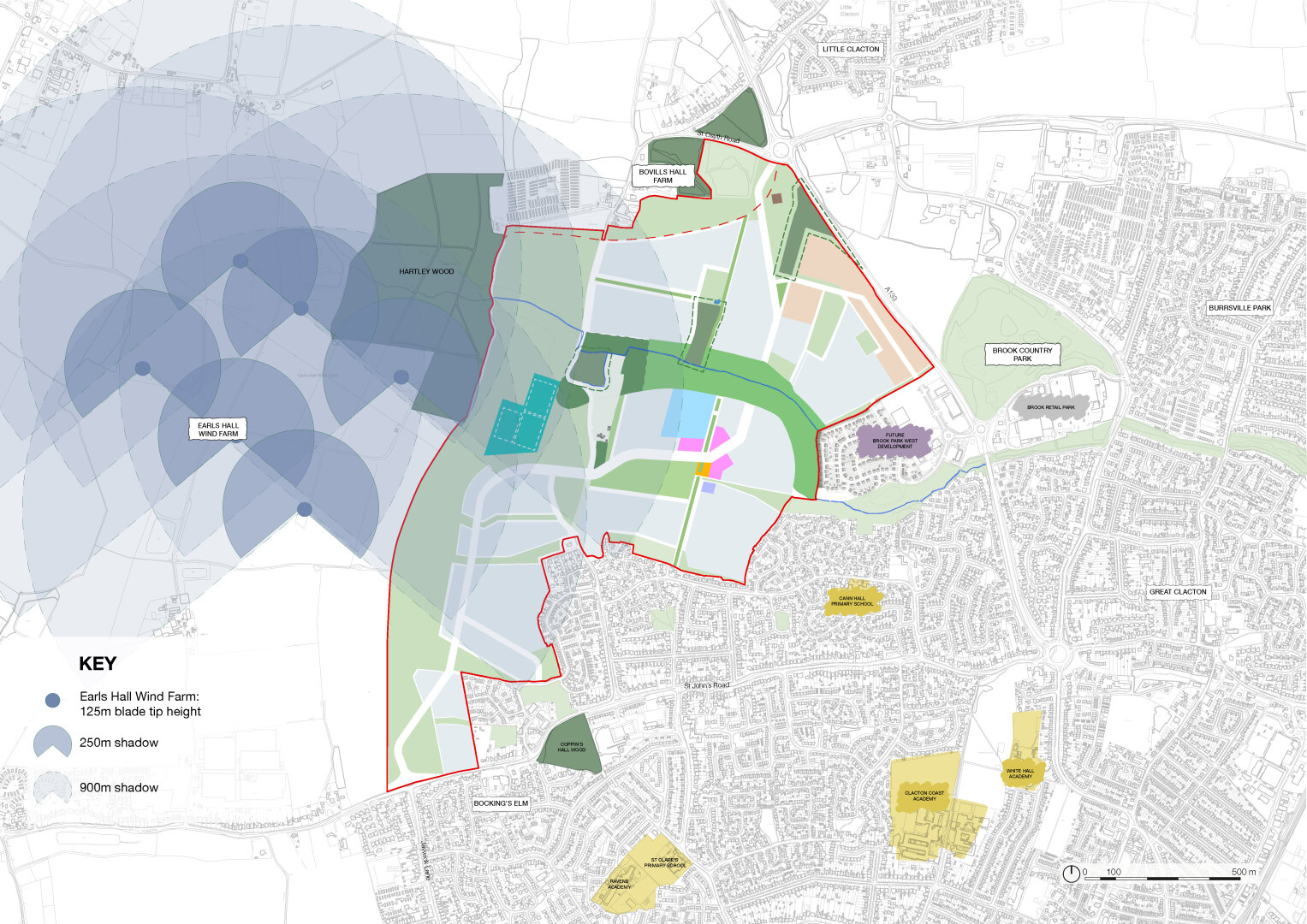
5.55. Rotating wind turbine blades can cause variation in brightness levels (shadow flicker) due to the blades disrupting sun rays. This can result in a nuisance when the shadow is cast over the windows of residential properties. This intermittent shadow is described by the term 'shadow flicker'. Shadow flicker effects can only occur under specific conditions, i.e. shadow flicker cannot occur if the weather is not clear and sunny or if the rotor is not orientated in a certain direction.
5.56. Shadow flicker effects are possible along the western edge of the Site of properties within 130 degrees either side of north, relative to the turbines.
Shadow flicker mitigation will be secured through principles within the Design Codes where homes may be impacted. The relevant Design Code should set out how the mitigation principles such as layout, orientation, and landscape screening are helping to mitigate the potential impact.
Employment uses should be located adjacent to the A133 to mitigate the noise and air quality impacts onto residential properties and sensitive uses.
Where appropriate screening and mitigation, through the use of street trees and green infrastructure, will be provided to help improve air quality and reduce noise and fumes and other disruptive uses from the street network.
The siting of the school will be located away from main traffic routes in pedestrian friendly areas, such as Green Links and Pickers Park.
Resources and lifespan
CORE OBJECTIVES:

Taking climate action
POLICY/REFERENCES:
PPL 10 (Renewable Energy Generation and Energy Efficient Measures), Essex Design Guide (2018), ECC Essex Parking Guidance 2024, ECC Digital Strategy for Essex (2022)
Development proposals at the Site should demonstrate how renewable energy solutions have been included for new buildings, and be designed to facilitate the retro-fitting of renewable energy installations in the future. Energy efficiency standards including passive design, orientation, and form factor, must be further explored through the detailed design process to ensure that all buildings are designed and built to respond to the impacts of climate change.
Resource efficiency principles
5.57. Planning applications will need to be supported by a Renewable Energy Strategy, which demonstrates that all reasonable renewable energy generation and energy efficiency measures have been fully considered and incorporated into the design, layout, masterplan, and build methodology.
5.58. The Renewable Energy Strategy should cover the provision of electric vehicle and electric bicycle charging infrastructure, following ECC Essex Parking Guidance 2024, and as updated.
5.59. The Renewable Energy Strategy should consider water saving measures as well as rainwater capture and how they can be implemented.
5.60. Widespread use of SuDS will provide sustainable storm water management and maximise available water resource from rainfall.
Resource efficiency - The orientation and passive design of buildings and blocks must take into consideration sustainability criteria to minimise carbon release, reduce the risk of overheating, and create opportunities for energy saving and the use of greener technologies. Furthermore, the integration of vegetation, such as green roofs, walls, and strategic planting, should be utilised to provide natural shading, enhance thermal performance, and contribute to cooling during warmer months.
The energy hierarchy should be followed and a fabric first approach to building design should be adopted followed by incorporating low and zero carbon technologies into all buildings to provide energy, financial and carbon savings, and reduce carbon emissions to meet the government's net zero targets by 2050.
Provide safe and efficient electric vehicle charging points where new parking is required to support a shift from petrol and diesel fuel combustion and a transition to using electric vehicles.
Water saving measures shall ensure that all new homes can achieve a water consumption rate in accordance with LPS2 or other best practice targets as appropriate.
Design Codes should promote modern methods of construction (where appropriate). This should include the use of suitable low energy building materials to conform to BREEAM Excellent or other best practice targets as appropriate and equivalent.
Communication and technology principles
5.61. Digital connectivity is important for how we live and work, and in promoting economic prosperity, health and wellbeing, safety and security at Hartley Gardens. Hartley Gardens has a role to play in realising the ambitions set out in ECC's Digital Strategy for Essex in 2022, which provides goals for how digital connectivity is to be promoted and improved across Essex and to help promote and improve life in the county.22
Planning applications for all new residential, commercial, and other appropriate developments and uses should include an infrastructure strategy which incorporates a gigabit broadband connection and 5G mobile connectivity or similar, which provide data rates up to 20 Gbit/s and lower latency (1ms). This should include installation of appropriate cabling and ducting to and within the premises, and the infrastructure strategy should confirm how this will be provided, including standards and timescales for implementation. This will allow businesses to operate effectively, and residents to experience less delay while being cared for at home, working remotely, and/or attending meetings from home or other remote locations in the vicinity.
Sustainable construction principles
5.62. Reducing construction site waste is important because it lowers environmental impact, conserves natural resources, reduces disposal costs, and improves overall project efficiency and sustainability. Consideration should be given to promoting the following, where appropriate:
- a circular economy approach, where resources are kept in use for as long as possible, extracting the maximum value from them while in use, then recovered and regenerated at the end of their service life;
- whole life cycle carbon assessment to reduce emissions related to raw material supply, manufacturing and transport, construction process, and demolition and disposal; and,
- off-site and modern methods of construction.
5.63. Construction waste will be monitored through a 'Site-wide Waste Management Plan' to be agreed with the relevant Council(s).
3 National Design Guide (2021) - https://www.gov.uk/government/publications/national-design-guide
4 National Model Design Code (2021) - https://www.gov.uk/government/publications/national-model-design-code
5 Building for a Healthy Life (2020) - https://www.udg.org.uk/publications/othermanuals/building-healthy-life
6 Streets for a Healthy Life (2022) - https://www.gov.uk/government/publications/streets-for-a-healthy-life
7 Active Design Guidance (2023) - https://www.sportengland.org/guidance-and-support/facilities-and-planning/design-and-cost-guidance/active-design
8 Building with Nature - https://www.buildingwithnature.org.uk/
9 Essex Design Guide - https://www.essexdesignguide.co.uk/
10 Manual for Streets and Manual for Streets 2 - https://www.gov.uk/government/publications/manual-for-streets
11 Cycle Infrastructure Design (LTN 1/20) - https://www.gov.uk/government/publications/cycle-infrastructure-design-ltn-120
12 Bus User Priority (LTN 1/24) - https://www.gov.uk/government/publications/bus-user-priority-ltn-124
13 Secured By Design Design Guides - https://www.securedbydesign.com/guidance/design-guides
14 Local Transport Note 1/20 Cycle Infrastructure Design (2020) - https://www.gov.uk/government/publications/cycle-infrastructure-design-ltn-120
15 BS 8300-2:2018 Design of an accessible and inclusive built environment. Buildings - code of practice - https://www.thenbs.com/PublicationIndex/documents/details?Pub=BSI&DocID=320547
16 Essex Parking Guidance 2024 - https://www.essexdesignguide.co.uk/design-details/2024-essex-parking-guidance/
17 Mobility Hubs and Integrated Transport Halts Implementation Guide (2024) - https://www.essexdesignguide.co.uk/design-details/streetsand-roads/mobility-hubs/
18 ECC Sustainable Drainage Systems Design Guide - https://www.essexdesignguide.co.uk/suds
19 ECC Developers’ Guide to Infrastructure Contributions - https://www.essex.gov.uk/sites/default/files/2024-07/Developers%20Guide%202024.pdf
20 Essex School Organisation Service Garden Communities and Planning School Places - https://www.essex.gov.uk/schools-and-learning/schools/school-organisation-and-place-planning
21 Essex Place Services School Design Principles - https://www.essexdesignguide.co.uk/supplementary-guidance/schools-design-guidance/
22 Digital Strategy for Essex (2022) - https://www.superfastessex.org/media/1717/digital-strategy-for-essex-june-2022-accessible-version.pdf