Local Plan - Preferred Options Consultation Document (Reg18)
9 Delivering Places
9.1The Local Plan’s strategic objective for Employment/Commercial is:
“To provide for the development of employment land on a variety of sites to support a diversity of employment opportunities and to achieve a better balance between the location of jobs and housing, which will reduce the need to travel and promote sustainable growth up to the period of 2042.”
9.2and for Housing is:
“To provide new dwellings within Tendring District up to 2042 of sufficient variety in terms of sites, size, types, tenure and affordability to meet the needs of a growing and ageing population.” and “To deliver high quality sustainable new communities.”
9.3This chapter takes forward policies within Chapters 5 – Living Places and Chapter 6 – Prosperous Places, through site specific policies to achieve:
- Strategic Allocation Mixed-Use Sites: Sites that are expected to accommodate homes, jobs and community assets. These are listed as Policies SAMU1 – SAMU9;
- Strategic Allocations for Housing: Sites that are expected to principally deliver between 100-450 homes. See Policies SAH1 – SAH11
- Medium Site Allocations: Sites that are expected to principally deliver between 10 -99 homes; and
- Strategic Allocations for Employment: Sites expected to deliver jobs principally in the B category of the Use Class Order; namely office, light industrial, distribution and storage.
9.4Note: Housing small sites of 9 or less are accommodated by windfall and current consent allowances in Chapter 5 and therefore do not have site specific policies.
Strategic Allocations Mixed-use Development
SAMU1 Tendring/Colchester Borders Garden Community
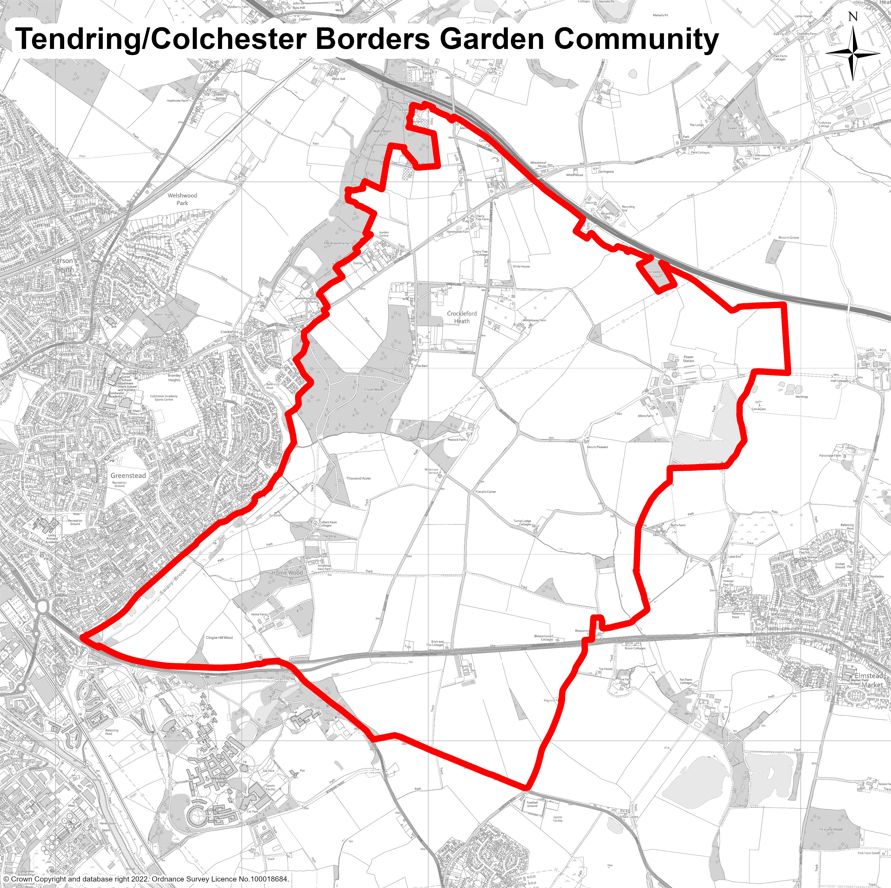
9.5Policy SAMU1 below sets out the specific requirements for the Tendring Colchester Borders Garden Community which will be developed over the next thirty or so years. This community will eventually comprise circa 7,500 homes, as well as employment spaces to accommodate new businesses and jobs.
9.6The Garden Community will include all the services and facilities that people will need, including new nurseries, primary and secondary schools, health facilities, and community facilities, including sports and leisure. It will need to be carefully designed to fit into the existing landscape, protecting the things that are important, whilst also providing new and improved green spaces, parks and areas for play.
9.7The principle of the Garden Community was established through policies SP8 and SP9 of Section 1 of the Tendring District Local Plan 2013-2033 and Beyond (which will be superseded upon adoption of this Local Plan). These policies will remain relevant in the determination of any future planning application for development at the Garden Community and are therefore ‘saved’ through this Local Plan and replicated within Appendix G. More detailed policies on the design and development of the Garden Community are included in the Tendring Colchester Borders Garden Community Development Plan Document (DPD), which was adopted in 2025. Policy SAMU1 below provides a summary of what will be included in the Garden Community and references housing numbers and the decision-making process.
DEVELOPMENT AND DELIVERY OF TENDRING COLCHESTER BORDERS GARDEN COMMUNITY
Land identified in the adopted Tendring Colchester Borders Garden Community Development Plan Document (DPD) and shown on the Policies Map is allocated for the development of the Tendring Colchester Borders Garden Community.
The Development Plan Document (DPD) allocates and protects land for the following uses:
- delivery of circa 7,500 new homes including 30% affordable housing, together with a range of shops, jobs, services and community facilities, including education and early years and childcare;
- a new ‘Salary Brook Country Park’ incorporating land and woodland at and around the Salary Brook Local Nature Reserve in Colchester;
- a ‘Wivenhoe Strategic Green Gap’ incorporating land north of Brightlingsea Road and west of Elmstead Road;
- an ‘Elmstead Strategic Green Gap’ east of the new A1331 Link Road;
- a Sports and Leisure Park to serve the local community and for the expansion of sports facilities for the University of Essex;
- approximately 25 Hectares of employment land in the form of a new Business Park and a ‘Knowledge-Based Employment’ site;
- provision for the Rapid Transit System;
- an 18-pitch Gypsy and Traveller Site; and
- a Park and Choose Facility. Proposals for development within the Site Allocation Boundary (as defined by the DPD Policies Map) will be determined in line with the policies and requirements set out in the Development Plan Document which itself will be the subject of a five-yearly review.
Decisions on planning applications for the Garden Community will be made by a Joint Committee containing representatives of Colchester City Council, Tendring District Council, and Essex County Council or successor organisations. Any proposed development within the Site Allocation Boundary that might prejudice the delivery or integrity of the Garden Community will be refused.
Within the Local Plan period up to 2042, the Garden Community is expected to deliver approximately 3,650 of the total 7,500 homes – with development continuing longer-term, beyond 2042, to completion. For this Local Plan period up to 2042, market and affordable housing delivery and employment land delivery from the Garden Community, irrespective of its actual location, will be distributed equally between Tendring District Council and Colchester City Council for the purposes of meeting respective housing and employment land requirements. Delivery of employment provision will also contribute to the supply for each of the authorities’ requirements.
The delivery of 18 pitches for Gypsies and Travellers will also count equally, 9 pitches each, towards Tendring District Council and Colchester City Council’s respective requirements. If, after considering its share of delivery from the Garden Community, if either of the authorities has a shortfall in delivery against the housing or Gypsy and Traveller pitch requirement for its area, it will need to make up the shortfall within its own area. It may not use the other authority’s share of delivery from the Garden Community to make up the shortfall.
Throughout the delivery of the Garden Community, Colchester City Council, Tendring District Council, and Essex County Council will continue to work together with developers and transport providers to maximise the potential opportunities and the reach of the Rapid Transit System and associated transport provision to serve communities in Colchester and Tendring.
Policies SP8 and SP9 of the North Essex Authorities Shared Strategic Section One Plan (Adopted January 2021) appended to this Plan will be saved and continue to apply to the Garden Community where appropriate. All other policies are replaced.
SAMU2 Hartley Gardens, Clacton
9.8Hartley Gardens is one of the largest proposed areas for mixed use development in the Local Plan. It is anticipated that housing delivery on the site will not commence until years 2029-2030 of the plan period. The Council wishes to see the delivery of a sustainable urban extension on the site that is planned and delivered through a master-planned approach, set out in the site-specific Hartley Gardens Supplementary Planning Document (SPD) adopted by the Council in December 2025. The SPD sets out a comprehensive and co-ordinated approach that identifies the land use, design, environmental and infrastructure requirements for the site and will be used to inform, assess and determine planning applications and co-ordinate a comprehensive, integrated and sustainable development and a high-quality well-designed place.
9.9The greenfield site comprises c. 163 hectares of arable land on the northwest edge of Clacton. The land is predominantly open arable farmland. There is an area of ancient woodland (Hartley Wood) to the northwest of the site and areas of woodland, hedges and trees within the site with both ecological and landscape value. Pickers Ditch is a notable site feature which runs along the south of the site and has been enhanced as a green infrastructure corridor through the Brook Park West development. The development of Hartley Gardens will need to both expand and integrate this green corridor. There are a number of footpaths that extend into the site and are used by local walkers. In terms of heritage assets, Bovills Hall contains Grade II listed buildings and archaeological remains to the direct north of the site. Bluehouse Farm, a Grade II listed building is located to the south of the site, and the Grade II listed farms or former farmhouses of Earls Hall Lodge and Duchess Farmhouse are to the south and west of the site.
9.10Policy SAMU2 below sets out specific requirements for this development site including the matters addressed in further detail through the Hartley Gardens SPD. The overall vision for this location is to deliver a high quality comprehensively planned new sustainable neighbourhood including the delivery of around 1,700 new homes over the next two decades, along with employment land, community infrastructure, and open spaces. Any planning applications for development should be consistent with Policy SAMU2 and other requirements set out in the SPD. The SPD deals with the whole site and its integration with its surrounding communities, wider countryside and the town centre. The Council will work with relevant landowners, developers and other partners, in consultation with the local community, to ensure that the development is delivered in a way that brings the supporting economic, social and environmental benefits to the community and the wider district.
9.11Given the current lack of capacity in the wider area for foul water treatment, it is essential that early engagement takes place with Anglian Water to ensure that adequate provision is made within the local foul water network to support the proposed development. In particular, this development must ensure increased capacity at the water recycling centres in Clacton or Jaywick to accommodate the additional growth.
9.12A Transport Assessment must be submitted with any planning application to identify suitable means of access. Where necessary, appropriate highway capacity and/or safety enhancements; improvements to public transport services and infrastructure; cycle; pedestrian and bridleway infrastructure enhancements will be provided. The Council will work with Network Rail, bus and train operators, Essex County Council and developers to explore opportunities to make improvements to Clacton-on-Sea train station; including improvements to facilities, frequency of services and the interchange between bus and rail transport.
DEVELOPMENT AT HARTLEY GARDENS, CLACTON
Land north of BockingsElm and west of A133 shown on the Map SAMU2 is allocated for long-term mixed-use development for the phased and comprehensive delivery of the following:
- Approximately 1,700 new homes of mixed sizes and types to meet evidenced local housing need within the Council’s most up-to-date Strategic Housing Market Assessment including affordable housing.
- Up to 7 hectares of land for employment.
- 2.1 hectares of land for a new two-form entry primary school with co-located 56-place early years and childcare facility, 1.3 hectares of land for a second 56-place stand-alone early years and childcare nursery and/or financial contributions towards primary school and secondary school provision as required by the Local Education Authority based on evidenced need.
- New facilities and/or financial contributions to support new health provision based on evidenced need.
- Green infrastructure which should provide a multi-functional and connected network, including amenity green space, parks, allotments, and natural and semi-natural green space (meeting the standards set out in Policy HP5) and providing for attractive green walking and cycling routes.
- To deliver the necessary level of biodiversity net gain in accordance with Policy PPL4a.
- A sustainable movement network, including principal points of highway access, a hierarchy of streets, facilitating public transport and prioritising the connection of walking and cycling routes within the site and beyond.
- The provision of sufficient utility infrastructure working with the relevant infrastructure providers to ensure that such provision is achieved in a timely manner.
Masterplanning Approach
The development will follow a comprehensively master-planned approach to be set out in the site-specific Supplementary Planning Document (SPD) that was adopted by the Council in 2025. All applications relating to land within the Hartley Gardens allocation will be determined in accordance with the requirements and guidance set out within the SPD. The purpose of the SPD is as follows:
- Provide further detail on the geographical extent and boundary of the allocation, ensuring a defensible and sensitive boundary to the open countryside beyond.
- Provide the means to inform, assess and determine planning applications and secure comprehensive, co-ordinated and integrated sustainable development.
- Facilitate and support the co-ordination and timely delivery of the green, social and physical infrastructure necessary to facilitate growth in this location.
The above requirements aim to ensure the comprehensive and co-ordinated development of the site, to ensure the masterplanning principles below are addressed and to provide a clear delivery plan to ensure the right infrastructure is funded and delivered at the right place and at the right time.
Masterplanning Principles
The Hartley Gardens SPD provides further guidance to meet the following principles, and all development proposals should accord with these:
- Create a series of permeable and legible well-defined streets which prioritise cycle and pedestrian routes linking into the existing built-up area and local facilities (e.g., retail and schools).
- Identify off-site highway works required to support new development, their phasing and funding.
- Identify public transport measures to ensure sufficient access to the site by bus, rail, walking and cycling routes within the site with strong and positive linkages to the existing network.
- Create a high-quality built and natural environment that respects the built and landscape character and context of the local area and which reflects the guidance in the National Design Guide and the Essex Design Guide.
- Incorporate in the design of new development measures to minimise the contribution to climate change and to ensure new development is resilient and adaptable to the effects of climate change.
- Create a connected multi-functional green infrastructure network which protects and enhances existing site features of landscape and ecological value and any veteran trees, hedgerows and other important landscape features and habitats.
- Ensure no net loss of biodiversity, and deliver a net gain in accordance with Policy PPL4a, as well as securing positive benefits to biodiversity through the restoration, enhancement and creation of appropriate semi-natural habitats within and through the site to maintain, restore and create functional ecological networks.
- Establish a sustainable drainage system across the site that integrates with the green infrastructure network and utilises, where practicable, existing watercourses (e.g., Hartley Brook and Pickers Ditch), ponds, ditches and any greenways associated with retained hedgerows and maximised habitat value.
- Create a landscape structure that retains and utilises existing landscape features (such as hedgerows, trees, Hartley Brook and Pickers Ditch) and uses new planting and landscaping to sensitively integrate new built development and provide an attractive green setting.
- Use structural planting and the location, orientation and design of new buildings to maintain the landscape setting and separate identity of Little Clacton and to carefully screen and sensitively integrate new infrastructure and buildings from the open countryside to the west to minimise any visual impact.
- Identify opportunities to preserve and enhance the setting and significance of heritage assets, including at Bovills Hall, Earls Hall and Dutchess Farmhouse and Bluehouse Farm.
- Where an archaeological evaluation (trial trenching where necessary) identifies surviving archaeological deposits, an appropriate mitigation strategy for preservation in situ or by excavation should be submitted.
- Demonstrate that no internationally designated sites would be adversely affected by the development either alone or in combination with other proposals as per the requirements of Policy PPL4, and future proposals will need to demonstrate no adverse impact on water quality.
- Demonstrate how a phased approach to development can deliver the required infrastructure in a coordinated and timely manner and create an integrated and sustainable community.
SAMU3 Oakwood Park, Clacton
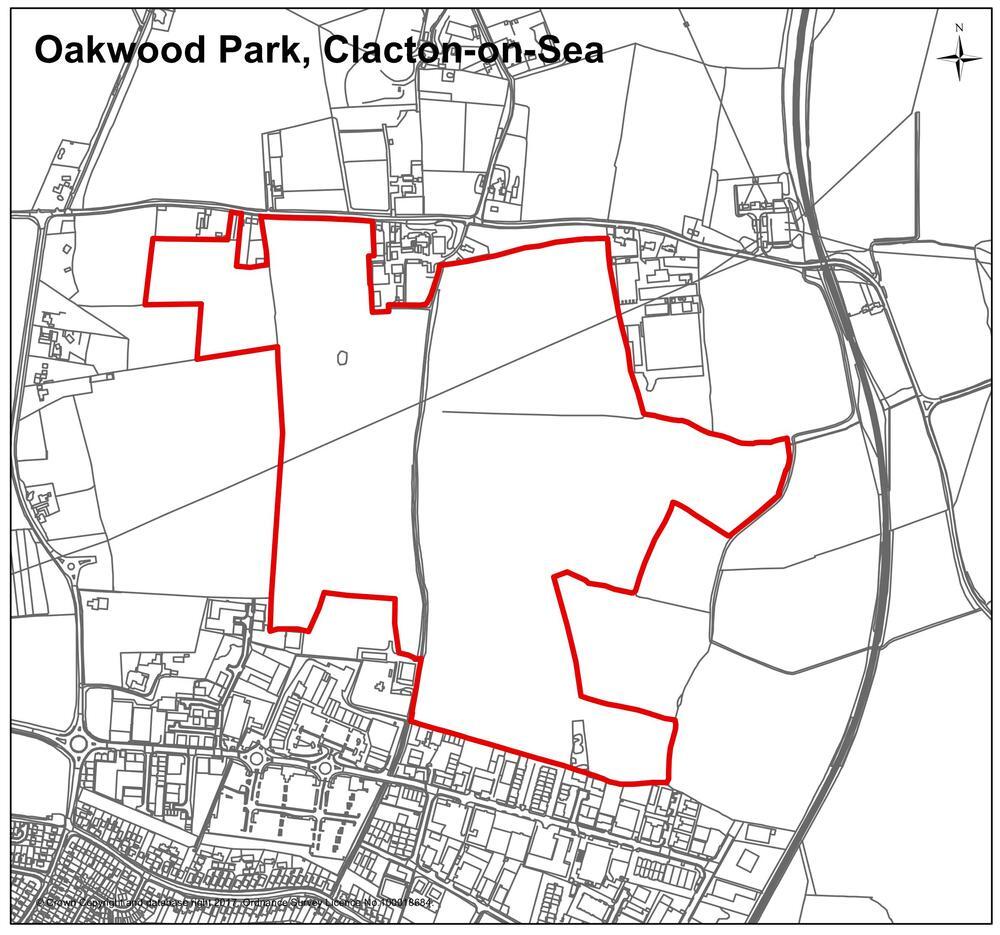
9.13Policy SAMU3 below sets out specific requirements for the extension of a recent housing development at Oakwood Park (planning approval reference number 15/01781/OUT). This extended mixed-use development includes a further 900 homes.
9.14Any planning applications for future development will be expected to comply with and assist in the delivery of this housing requirement along with other relevant policies in the Local Plan. The Council will work with relevant landowners, developers and other partners, in consultation with the local community, to ensure that the development is delivered in a way that brings economic, social and environmental benefit to the community and the wider district.
9.15A watercourse crosses the site which creates an opportunity to deliver a water feature within the site which could serve as a sustainable surface water management system, including an attenuation lagoon. As there will be insufficient future capacity available in the wider area for the treatment of foul water, it is important that engagement with Anglian Water takes place at an early stage to ensure that sufficient capacity in the local foul water system is created to accommodate the new development.
9.16A Transport Assessment must be submitted with any planning application to identify suitable means of access with the firm preference being to utilise the recently built, high capacity, roundabout on Thorpe Road which serves the adjacent commitment to the west. Where necessary, appropriate highway capacity and/or safety enhancements; improvements to public transport services and infrastructure; cycle; pedestrian and bridleway infrastructure enhancements will be provided.
DEVELOPMENT AT OAKWOOD PARK, CLACTON
Land north of Clacton-on-Sea, between Holland Road and the Oakwood Business Park (Oakwood Park, Clacton), shown on the Map SAMU3, is allocated for a mix of residential development, community facilities and public open space as follows:
- approximately 900 new homes of mixed sizes and type to include affordable housing and dwellings designed to address the needs of older residents;
- approximately 3 hectares of public open space;
- approximately 2.1 hectares of land for a new two-form entry primary school with co-located 56 place early years and childcare facility (Class F.1 use) as required by the Local Education Authority through Section 106 Planning Obligations;
- approximately 2 hectares of land for care and extra care facilities;
- approximately 2 hectares of land for a neighbourhood centre to include local shops, services and community facilities; and
- approximately 1.0 hectares of land for health care facilities;
Proposals must accord with the following:
- inclusion of development at urban to suburban densities (average of 30 dph) and include a master planned approach which addresses the opportunities for further development post-2033 and does not preclude any future development on adjoining land;
- the principal point of vehicular access should be off Thorpe Road through the approved housing development on land to the west utilising the recently constructed roundabout and only if necessary a secondary access off Holland Road to the north;
- capacity and/or safety enhancements to the local highway network where necessary;
- where necessary, enhancements to public transport, cycle, pedestrian, and bridleway infrastructure;
- delivery of opportunities for the protection and enhancement of the historic environment features and settings including the built and archaeological environment as well as the rural character of the bridleway running through the centre of the site;
- where an archaeological evaluation (trial trenching where necessary) identifies surviving archaeological deposits, an appropriate mitigation strategy for preservation in situ or by excavation should be submitted;
- the design and layout of the development must have regard to the surrounding landscape, seeking to minimise visual impacts through the inclusion of mitigation measures to deliver links with the existing landscape and access features. As part of this, appropriate landscaping treatment along the northern and eastern fringes of the site is required to minimise visual impacts;
- financial contributions to early years and childcare, primary and secondary education provision, as required by the Local Education Authority primarily through Section 106 Planning Obligations or the Community Infrastructure Levy;
- early engagement with Anglian Water to secure upgrades to both treatment infrastructure and network and to formulate a water and drainage strategy to serve the new development; and
- financial contributions towards community facilities such as health provision as required by the NHS/CCG either through the Community Infrastructure Levy or Section 106 Planning Obligations.
SAMU4 Rouses Farm, Clacton
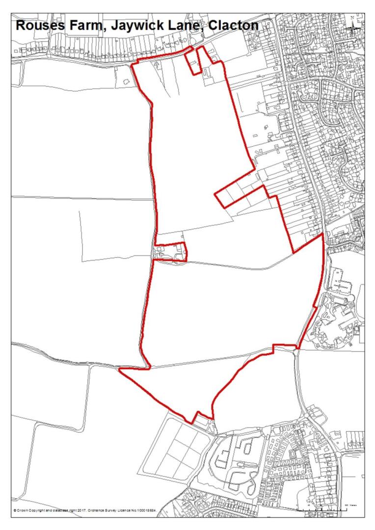
9.17Policy SAMU4 below sets out specific requirements for this site. The western and north-western periphery of Clacton is relatively unaffected by significant physical and environmental constraints. As well as providing a mix of new housing, this development will provide land for a new primary school, a new primary health care centre and a significant area of new open space. The non-housing elements of the development will deliver a number of local jobs in the public and private sector, particularly in health and education. The overall increase in new households will help support growth in the wider economy including spending and investment in the town centre and other service-sector industries.
9.18A Transport Assessment must be submitted with any planning application to identify suitable means of access. Where necessary, appropriate highway capacity and/or safety enhancements; improvements to public transport services and infrastructure; cycle; pedestrian and bridleway infrastructure enhancements will be provided.
9.19Any planning applications for development will be expected to comply with, and assist in the delivery of these concepts and requirements along with other relevant policies in the Local Plan. The Council will work with relevant landowners, developers and other partners, in consultation with the local community, to ensure that the development is delivered in a way that brings economic, social and environmental benefit to the community and the wider district.
9.20As there is currently insufficient capacity available in the wider area for the treatment of foul water, it is important that engagement with Anglian Water takes place at an early stage to ensure that sufficient capacity in the local foul water system is being created to accommodate the new development. In particular, it should be ensured that there is sufficient capacity at the water recycling centre in Jaywick to accommodate the additional growth.
9.21Planning permission has already been granted for the development at the Rouses Farm site and it is anticipated that development will commence in the early part of the Plan Period. Policy SAMU4 is, however, retained within the Local Plan in the event that further planning applications are submitted for consideration.
DEVELOPMENT AT ROUSES FARM, JAYWICK LANE, CLACTON
Land at Rouses Farm, west of Jaywick Lane and south of St. John’s Road, Clacton-on-Sea, as defined on Map SAMU4, is allocated for a mix of residential development, community facilities and public open space as follows:
- up to 950 new homes of mixed sizes and types to include affordable housing as per the Council’s requirements, and features to support a range of housing sizes and types to reflect the needs of the area requirements;
- a new two-form entry primary school with co-located 56 place early years and childcare facility (Class F.1 use) on 2.1 hectares of land as required by the Local Education Authority through Section 106 Planning Obligations;
- a new neighbourhood centre;
- infrastructure or a financial contribution towards the delivery of healthcare capacity to meet the needs of the growing population in West Clacton;
- a minimum of 5 hectares of public open space;
Proposals must accord with the following:
- inclusion of a master planned approach;
- the principal points of vehicular access will be off St John’s Road in the north and Jaywick Lane in the south;
- the design and layout of the development must have regard to the surrounding landscape, seeking to minimise visual impacts through the inclusion of mitigation measures to deliver links with the existing landscape and access features. As part of this, a minimum 20 metre landscaping buffer along the western edge of the site is required to minimise visual impacts;
- the layout of the site is expected to include a new spine road with a carriageway width of 6.75 metres, linking St John’s Road and Jaywick Lane, which is capable of accommodating buses and other large vehicles, enabling traffic calming measures or access restrictions to be implemented in Jaywick Lane which will benefit existing residents in that area;
- where necessary and/or appropriate, incorporation of highway capacity, safety, public transport, cycle, pedestrian and bridleway service and/or infrastructure enhancements. A safe cycle path/footpath between the development and the Clacton Coastal Academy and new primary school is required;
- a financial contribution to early years and childcare and secondary education provision, as required by the Local Education Authority through Section 106 Planning Obligations;
- delivery of opportunities for the protection and enhancement of the historic environment features and settings including the built and archaeological environment; and
- early engagement with Anglian Water to secure upgrades to both treatment infrastructure and network and to formulate a water and drainage strategy to serve the new development.
SAMU5 Land off Deane’s Lane and Oakley Road, Dovercourt
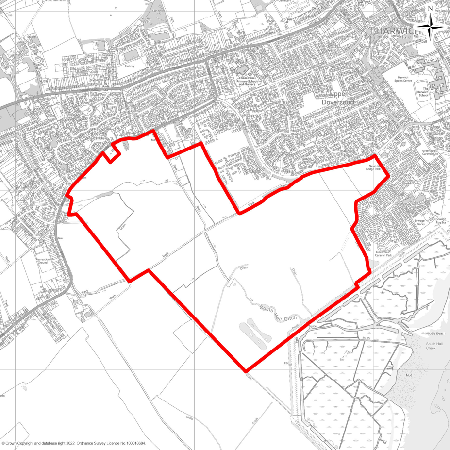
9.22The Harwich and Dovercourt area is identified as a Strategic Urban Settlement in Policy the SPL1 of this Local Plan which, alongside Clacton, the new Tendring Colchester Borders Garden Community, and the Hare Green and Horsley Cross Garden Villages will be a primary focus for growth in new jobs and housing in the period to 2042 and beyond. With the establishment of Freeport East and related opportunities for significant investment in the economy and the creation of jobs at Bathside Bay and other locations along the A120 corridor, the demand for new housing is expected to grow.
9.23This Local Plan makes provision for approximately 2,500 new homes in the Harwich and Dovercourt area over the period to 2042 of which 637 had already received planning permission or were under construction at 1st April 2025. There is a limited supply of previously developed brownfield land in the Harwich and Dovercourt area and elsewhere in the Tendring district and due to its sensitive coastal geography, there are very limited locations around the edge of Harwich and Dovercourt where expansion onto greenfield land can realistically take place.
9.24The largest proposed allocation is an area of greenfield land south of Dovercourt, west of Deane’s Lane, south of Oakley Road and to the west of the recent Languard View development off Low Road. Policy SAMU5 below allocates the land for a development of approximately 1,650 homes as part of a mixed-use development including community facilities and public open space. To ensure the development is carried out in a comprehensive manner and incorporates key infrastructure in the right place and at the right time, the development will be guided by an overarching masterplan.
DEVELOPMENT OFF DEANE’S LANE AND OAKLEY ROAD, DOVERCOURT
Land to the south-west of Dovercourt, to the west of Deane’s Land and to the south of Oakley Road, as shown on the Map SAMU5, is allocated for the future development of new housing, community facilities and public open space as follows:
- approximately 1,650 new homes of mixed sizes and type to include affordable housing in accordance with the Council’s requirements as set out in policy LP5, and serviced land for self-build and custom-built homes;
- approximately 50 hectares of strategic open space in accordance with policy HP5, incorporating connection between Little Oakley in the east west to the open space at the Languard View development off Low Road, Dovercourt;
- land at the centre of the development for the provision of education and early years and childcare, and/or financial contributions towards early years and childcare, primary and secondary education provision as required by the Local Education Authority based on evidenced need; and
- approximately 2 hectares of land for a neighbourhood centre to include local shops, services and community facilities.
Proposals must accord with an overarching masterplan either prepared by, or submitted to and approved by, the Council before or concurrently with any planning application. The masterplan and planning applications will be expected to address the following, alongside other relevant requirements of this Local Plan:
- a requirement for 20% biodiversity net gain;
- the principal point of vehicular access should be off the B1414 Oakley Road;
- capacity and/or safety enhancements to the local highway network where necessary;
- where necessary, enhancements to public transport, cycle, pedestrian, and bridleway infrastructure;
- delivery of opportunities for the protection and enhancement of the historic environment features and settings including the built and archaeological environment;
- where an archaeological evaluation (trial trenching where necessary) identifies surviving archaeological deposits, an appropriate mitigation strategy for preservation in situ or by excavation should be submitted;
- the design and layout of the development must have regard to the surrounding landscape, seeking to minimise visual impacts through the inclusion of mitigation measures to deliver links with the existing landscape and access features. As part of this, appropriate landscaping treatment along the southern and western edge the site is required to minimise visual impacts;
- development proposals must be designed to enable and support the habitat priority measures identified within the Strategic Opportunities set out in the Essex Local Nature Recovery Strategy (LNRS);
- financial contributions to early years and childcare, primary and secondary education provision, as required by the Local Education Authority primarily through Section 106 Planning Obligations or the Community Infrastructure Levy;
- early engagement with Anglian Water to secure upgrades to both treatment infrastructure and network and to formulate a water and drainage strategy to serve the new development; and
- financial contributions towards community facilities such as health provision as required by the NHS/ICB either through the Community Infrastructure Levy or Section 106 Planning Obligations.
This development may also be required to contribute to wider works and upgrades to the A120, in accordance with up-to-date evidence and advice from National Highways.
SAMU6 Weeley Green Garden Village
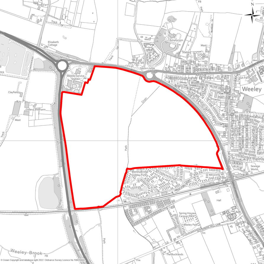
9.25Land is allocated to the west of Weeley for the development of a Garden Village – which will take the form of a strategic expansion of the existing village. Weeley offers significant advantages as a location for strategic growth, including its central position within the District; excellent connectivity via the A133 to Clacton and the B1033 to Frinton and Walton; a railway station on the Walton to Colchester branch line; existing educational provision with a primary school and outline consent for a new two-form entry school at Barleyfields; and the availability of relatively unconstrained land with direct access to strategic transport infrastructure.
9.26Given the physical and environmental constraints, the limited capacity for additional development in the Thorpe le Soken and Frinton, Walton and Kirby Cross areas, and the limitations of the B1033 to the east of Weeley, strategic growth west of Weeley has the potential to address some of the demand for housing and employment in the wider area that would otherwise not be possible to meet, whilst keeping the impact of new development on the capacity of the B1033 to a more manageable level.
9.27The scale of development envisaged at Weeley Green Garden Village is less than that of the Garden Villages proposed for Hare Green and Horsley Cross, comprising approximately 900 homes alongside associated facilities and open space. The development will be contained on the parcels of land bounded by Bypass Road, the B1033 Colchester Road, the A133, Tendring Park Services and Weeley Bridge Caravan Park. This scale reflects differences in housing demand and market strength further from Colchester, as well as land availability considerations. Additionally, land north of Colchester Road is allocated through Policy PPL7 for employment use.
9.28Unlike the other Garden Villages proposed in this Local Plan, it is anticipated that the entire development at Weeley could be achieved within the current Local Plan period to 2042, with any additional longer-term development, if needed, being the subject of future Local Plan reviews.
9.29To ensure the development of the new Garden Village is comprehensively planned from the outset to achieve the highest possible standard of quality, achieving positive integration with the existing village and the delivery of services, facilities and infrastructure in the right place at the right time, planning applications will be determined in accordance with a site-specific Supplementary Planning Document (SPD) or comprehensive masterplan. This will either be prepared by the Council or prepared for the Council’s approval ahead of any decisions on planning applications and will identify the specific land use, design, environmental and infrastructure requirements for the development. Policy SAMU9 below sets out specific requirements for the Garden Village development, including the matters to be addressed through the SPD or masterplan.
9.30A notable requirement of this development will be the need for a Transport Assessment to be submitted with any planning application to identify suitable means of access and necessary delivery of new, or upgrades to existing, transport infrastructure including comprehensive walking and cycling connections to new and existing services and facilities within the development and wider existing village; improvements to facilities and service provision at Weeley railway station; improvements to bus services; and improvements to the A133 and associated junctions between Weeley and Frating and the other proposed Garden Village at Hare Green.
DEVELOPMENT OF WEELEY GREEN GARDEN VILLAGE
Land west of Weeley is allocated for a major residential and mixed-use development that alongside the existing community and housing development already under construction to the east will establish a new Garden Village of a scale that will contribute significantly towards meeting the District’s housing and employment needs and delivering new and improved infrastructure whilst benefitting from a central location with good access to road and rail infrastructure. The land identified on the Map SAMU6 and the Local Plan policies map is allocated for housing, community facilities and public open space as follows:
- approximately 900 new homes of mixed sizes and type to include affordable housing in accordance with the Council’s requirements as set out in policy LP5, and serviced land for self-build and custom-built homes;
- approximately 16 hectares of strategic open space in accordance with policy HP5, located mostly in the form of a large village green to serve the whole expanded village, visible and prominent to the west of Bypass Road close to its junction with The Street and forming wider connections throughout the development and to the existing community and local facilities including railway station and village hall; and
- approximately 2 hectares of land for a neighbourhood centre to include local shops, services and community facilities located to serve the whole expanded village.
Proposals must accord with an overarching masterplan either prepared by, or submitted to and approved by the Council before or concurrently with any planning application. The masterplan and planning applications will be expected to address the following, alongside other relevant requirements of this Local Plan:
- a requirement for 20% biodiversity net gain;
- the principal points of vehicular access should be off the existing roundabout on the interchange of the B1033 and B1441, and via or close to the existing access to the railway station;
- capacity and/or safety enhancements to the local highway network where necessary – including capacity and safety upgrades to the A133 between Weeley and Frating and junctions along it; traffic calming measures for the existing village and safe pedestrian crossings on Colchester Road and Bypass Road;
- enhancements to public transport, cycle, pedestrian, and bridleway infrastructure –including improvements to the public realm and safety measures. This will incorporate safe, attractive pedestrian and cycle connections to Weeley Railway Station, upgrades to station facilities, and comprehensive walking, cycling, and bridleway links throughout the development, ensuring strong integration with the existing village.
- delivery of opportunities for the protection and enhancement of the historic environment features and settings including the built and archaeological environment;
- where an archaeological evaluation (trial trenching where necessary) identifies surviving archaeological deposits, an appropriate mitigation strategy for preservation in situ or by excavation should be submitted;
- the design and layout of the development must have regard to the surrounding landscape, seeking to minimise visual impacts through the inclusion of mitigation measures to deliver links with the existing landscape and access features;
- development proposals must be designed to enable and support the habitat priority measures identified within the Strategic Opportunities set out in the Essex Local Nature Recovery Strategy (LNRS);
- financial contributions to early years and childcare, primary and secondary education provision, as required by the Local Education Authority primarily through Section 106 Planning Obligations or the Community Infrastructure Levy – which will include contributions towards the construction of the 2-form entry primary school at the Barleyfields development to the east of Weeley which already has the benefit of outline planning permission;
- financial contributions towards the expansion and/or upgrade of Weeley village hall to serve an expanded community and to provide flexible accommodation for a range community activities that could include health services;
- early engagement with Anglian Water to secure upgrades to both treatment infrastructure and network and to formulate a water and drainage strategy to serve the new development; and
- financial contributions towards community facilities such as health provision as required by the NHS/ICB either through the Community Infrastructure Levy or Section 106 Planning Obligations.
Through the use of planning conditions, legal obligations or other restrictions, the Council will seek to control restrict the number of new homes that can be built and occupied until such time that key infrastructure and/or other requirements of this policy are met – in particular the construction of the primary school and early years facility at the Barleyfields development east of the village.
Land north of Colchester Road is separately allocated through Policy PPL7 for 2 hectares of employment land which will support the housing growth proposed for the Weeley Green Garden Village – subject to appropriate pedestrian and cycle connections between the employment and resident development being achieved.
SAMU7 Saltings Quarter, Riverside Avenue, Manningtree
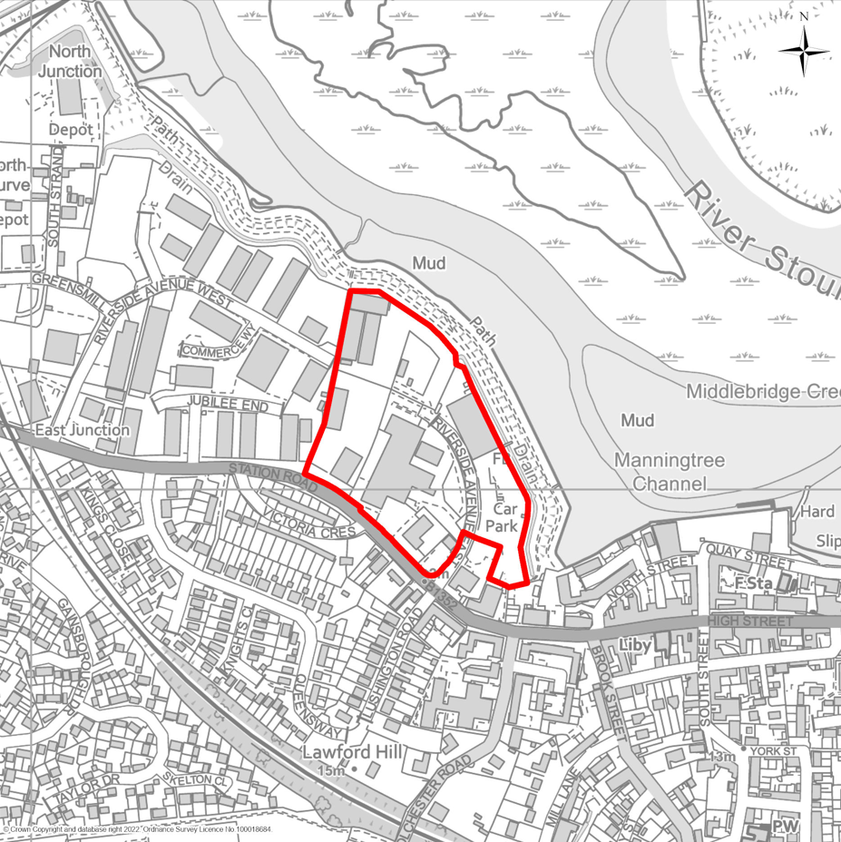
9.31The Saltings Quarter site is currently a predominantly industrial and commercial area, incorporating some rundown and underused industrial land alongside a food store and car park. Over the past decade, the area has steadily evolved, with more residential uses introduced to the south and east, extending towards the settlement nucleus of Manningtree.
9.32Part of the site, particularly the western area, was a designated employment site in the previous Local Plan. Consequently, any redevelopment should retain provision for industrial and commercial uses to the west in order to deliver a truly sustainable, mixed-use development.
9.33The site benefits from good access to Manningtree Station to the west, is located close to Manningtree town centre to the east and includes land that forms part of a designated Neighbourhood Centre. Moreover, the entire site is constrained by flood risk due to its proximity to the River Stour.
9.34Policy SAMU7 sets out specific requirements for development at this location. Any planning application will be expected to comply with this policy, alongside other relevant policies in the Local Plan. The Council will work collaboratively with landowners, developers, and other partners, in consultation with the local community, to ensure the development delivers economic, social, and environmental benefits for both the local area and the wider district.
9.35As part of this process, the Council will support developers in relocating the existing food store to a more suitable position within the site, ensuring this valuable commercial function is retained in line with policy requirements. The site is anticipated to become vacant and available for redevelopment during the Plan period. In preparation for this, the Council will provide support to ensure that existing commercial and industrial businesses are successfully relocated to suitable locations within the area.
9.36Development should adopt a comprehensive approach to regeneration, addressing key constraints such as flood risk and potential land contamination. Given the sensitive setting of the site and its close proximity to the Manningtree and Mistley Conservation Area, particular emphasis must be placed on achieving high-quality design and ensuring that new development integrates seamlessly with the existing character and appearance of the village.
REDEVELOPMENT OF SALTINGS QUARTER, RIVERSIDE AVENUE, MANNINGTREE
Land at Saltings Quarter, Riverside Avenue, Manningtree, as defined on Map SAMU7, is allocated for a mix of residential development, commercial use, public open space, and public realm enhancements as follows:
- Delivery of approximately 40 new dwellings of varied size and type, including affordable housing in line with the Council’s requirements under policy LP5. Development should follow a comprehensive, phased masterplan approach that addresses site constraints such as flood risk and land contamination.
- Development should be at densities appropriate to an urban setting.
- Provision of a compatible mix of commercial and industrial uses in suitable locations, with careful consideration of neighbouring amenity.
- Successful relocation of the existing food store to an appropriate location on the site, maintaining a similar size and function.
- Environmental enhancement along Station Road, the river frontage, and between residential, commercial and any industrial uses through the introduction of appropriate separation, green buffers, landscaped areas, and biodiversity zones. Across the site, enhanced green infrastructure should be provided to:
- a requirement for 20% biodiversity net gain including habitat creation by designing the development to actively enable and support the priority habitat measures identified in the Strategic Opportunities of the Essex Local Nature Recovery Strategy (LNRS);
- support nature conservation and landscape quality;
- enhance public connectivity, with a particular focus on creating safe, accessible, and attractive pedestrian and cycle links between Station Road and the river frontage of the site, as well as along the riverside corridor; and
- establish new public open spaces within the site.
- Development should respond positively to the character and setting of the nearby Manningtree and Mistley Conservation Area.
- Contributions should be made towards flood risk mitigation, in accordance with relevant policies in this plan, the NPPF, national legislation, and the Surface Water Management Plan for Critical Drainage Areas.
- Proposals should explore opportunities to improve and enhance the river environment, including river restoration, ecological enhancement, and provision of flood storage areas.
- Residential development should be located away from contaminated land. Where contamination is present, appropriate mitigation measures must be agreed with the Council.
- Surface water from the development must be discharged in an attenuated form to a receiving waterbody, and not to the combined sewer network, unless no alternative is feasible.
- Adequate wastewater management capacity must be demonstrated, including proposed phasing or alternative solutions, to the satisfaction of the Council and in consultation with Anglian Water.
- A range of measures should be implemented to reduce pressure on WRC capacity, in addition to prioritising SuDS and water efficiency, including:
- Removal of unnecessary network flows
- Targeted education for new residents
- Reduction in demand for potable water
- financial contributions to early years and childcare, primary and secondary education provision, as required by the Local Education Authority primarily through Section 106 Planning Obligations or the Community Infrastructure Levy;
- financial contributions towards community facilities such as health provision as required by the NHS/ICB either through the Community Infrastructure Levy or Section 106 Planning Obligations.
- Delivery of any site-specific infrastructure identified in the Infrastructure Delivery Plan, which may include:
- Highway mitigation
- Flood risk mitigation
- Water and wastewater infrastructure
- Specific community and open space facilities
SAMU8 Hare Green Garden Village
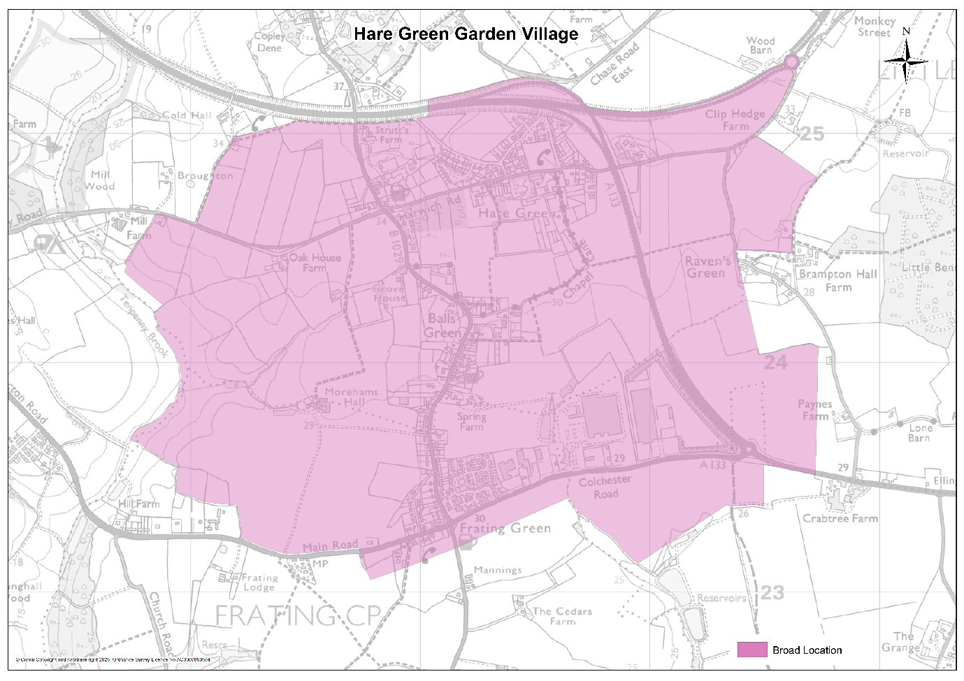
9.37As set out in Policy LP1 of this Local Plan, the Council must plan for the development of 18,071 new homes between 2025 and 2042 to comply with government policy on housebuilding. Approximately 10,700 of these will be delivered from sites that were either already allocated for development in the Council’s previous Local Plan or sites that have otherwise already obtained planning permission or are under construction – mainly on land around Clacton and at the Tendring Colchester Borders Garden Community. This has required the Council to identify land and locations to deliver an additional 7,400 homes.
9.38Around half of this additional growth is to be accommodated through major expansion at Harwich (see Policies SAMU5 and SAH1) alongside modest and smaller-scale expansion of Tendring’s other towns and villages. However, to deliver the remainder of the requirement up to 2042 and place the District on a sound footing for longer-term growth beyond this period, the Council considers it necessary to establish three new communities in strategically important locations towards the centre of the District. These locations will accommodate growth on a scale that will require and deliver both new infrastructure and key improvements to existing infrastructure and that will be comprehensively planned from the outset to deliver growth for the long term. The three locations for new ‘Garden Villages’ are at Hare Green, Horsley Cross and Weeley.
9.39The Hare Green Garden Village is proposed for land in and around Frating and the Hare Green area of Great Bromley at the important transport interchange between the A120 and the A133. The proposal reflects the ‘Tendring Central Garden Village’ concept put forward to the Council for consideration as part of the Local Plan review process by a consortium of local landowners. The benefits of this area as a location for strategic growth in the form of a new Garden Village include its proximity to both existing and potential centres of employment activity, the potential to connect to an extended Rapid Transit System to and from Colchester and the opportunity to facilitate the construction of an omni-directional junction that links the A120 and A133 in all directions, addressing poor north-south road links in the District and enabling faster and direct movement between Clacton and Harwich area.
9.40To ensure the development of the new Garden Village is comprehensively planned from the outset, is served by the necessary infrastructure at the right time and does not prejudice either the operation of the A120 nor the delivery of the Tendring Colchester Borders Garden Community to the west, the development will be led through the preparation of a Masterplan and a separate Development Plan Document (DPD). The Council will also impose restrictions, either through the DPD, planning conditions or legal obligations to ensure that no new homes at the new Garden Village are occupied until the A120/A133 link road at the Tendring Colchester Borders Garden Community has been completed and is in operation, the omni-directional junction at the A120/A133 interchange has been delivered and the Rapid Transit System serving the Tendring Colchester Borders Garden Community has been extended to connect and serve the existing and new community.
9.41The new Garden Village will be expected to embrace the ‘Garden Community Principles’ established through the planning and delivery of the Tendring Colchester Borders Garden Community. Policy SAMU8 below therefore outlines these expectations, in a similar way to how they were set out in the Council’s previous Local Plan in respect of the Tendring Colchester Borders Garden Community. All development forming part of the new Hare Green Garden Village will therefore be expected to comply with these principles:
- Community and stakeholder participation in the design and delivery of the Garden Village from the outset and a long-term community engagement and activation strategy.
- The public sector working pro-actively and collaboratively with the private sector to design and bring forward the Garden Village, deploying new models of delivery where appropriate and ensuring that the cost of achieving the following is borne by landowners and those promoting the developments: (a) securing a high-quality of place-making, (b) ensuring the timely delivery of both on-site and off-site infrastructure required to address the impact of the new community, and (c) providing and funding a mechanism for future stewardship, management, maintenance and renewal of community infrastructure and assets. Where appropriate, developers will be expected to contribute towards any publicly funded infrastructure. Given the scale of and time period for development of the new Garden Village, the appropriate model of delivery will need to secure a comprehensive approach to delivery in order to achieve the outcomes outlined in points (a) - (c) above, avoid a piecemeal approach to development, provide the funding and phasing of both development and infrastructure, and be sustainable and accountable in the long term.
- Promotion and execution of the highest quality of planning, design and management of the built and public realm so that the Garden Village is characterised as a distinctive place that capitalises on local assets, respects its context, and establishes an environment that promotes health, happiness and well-being.
- Sequencing of development and infrastructure provision (both on-site and off-site) to ensure that the latter is provided ahead of or in tandem with the development it supports to address the impacts of the new Garden Village, meet the needs of its residents and establish sustainable travel patterns. To ensure new development does not have an adverse effect on any European Protected or nationally important sites and complies with environmental legislation (notably the Water Framework Directive and the Habitats Directive), the required wastewater treatment capacity must be available ahead of the occupation of dwellings.
- Development that provides for a truly balanced and inclusive community and meets the housing needs of local people including a mix of dwelling sizes, tenures and types, provision for self- and custom-built homes, provision for the aging population; and provision for Gypsies and Travellers; and that meets the requirements of those most in need including the provision of affordable housing in the Garden Village.
- Provide and promote opportunities for employment within the new Garden Village and within sustainable commuting distance of it.
- Plan the new community around a step change in integrated and sustainable transport systems for the wider area that put walking, cycling and rapid public transit networks and connections at the heart of growth, encouraging and incentivising more sustainable active travel patterns.
- Design the new community to create sociable, vibrant and walkable neighbourhoods with equality of access for all to a range of community services and facilities including health, education, retail, culture, community meeting spaces, multi-functional open space, sports and leisure facilities.
- Develop specific parking approaches and standards that help promote the use of sustainable transport and make efficient use of land.
- Create distinctive environments based on comprehensive assessments of the surrounding environment that celebrate natural and historic environments and systems; utilise a multi-functional green-grid to create significant, connected networks of new green infrastructure including a new country park at the garden village; provide a high degree of connectivity to existing corridors, networks, and assets; and enhance biodiversity.
- Secure a smart and sustainable approach that fosters climate resilience and a 21st century environment in the design and construction of the garden community to secure net gains in local biodiversity, highest standards of energy efficiency and innovation in technology to reduce the impact of climate change, the incorporation of innovative water efficiency/re-use measures (with the aim of being water neutral in areas of serious water stress), and sustainable waste and mineral management.
- Ensure that the costs and benefits of developing the Garden Village are shared by all landowners, with appropriate measures being put in place to equalise the costs and land contributions.
- Consideration of potential on-site mineral resources through a Minerals Resource Assessment as required by the Minerals Planning Authority.
- Establishment at an early stage in the development of the Garden Village, of appropriate and sustainable long-term governance and stewardship arrangements for community assets.
9.42Whilst it is proposed that the new Garden Village could start delivering new homes from 2033 and could contribute between 1,500 and 2,000 new homes towards housing delivery in the District up to 2042, the Council will keep the trajectory for development under review through annual updates to its Strategic Housing Land Availability Assessment (SHLAA) and if it becomes apparent, for whatever reason, progress is delayed and necessary timescales are not being met in order to achieve the planned rate of development; alternative or interim measures could be considered and incorporated into the Local Plan when it is next reviewed – by what will be the future unitary authority for the North Essex area.
9.43Because the Hare Green Garden Village is likely to be a long-term development of strategic significance, its inclusion in the Tendring District Local Plan will likely feature as a proposal in the future Spatial Development Strategy (SDS) for Greater Essex to be produced by the new Mayoral County Combined Authority (MCCA). Being a strategic proposal in the SDS will ensure the development is recognised as being of sub-regional importance, with the opportunity for assistance around delivery and funding for infrastructure channelled through the new powers that will be devolved from central government to the future Mayor.
DEVELOPMENT OF HARE GREEN GARDEN VILLAGE
The Frating, Hare Green and Great Bromley area of Tendring, at the interchange between the A120 and A133, is identified as the location for a new ‘Garden Village’ to be delivered within the broad area shown on Map SAMU7. This Garden Village will create a new community, integrated with existing villages, that could deliver around 4,500 new homes, provision of suitably located Gypsy and Traveller accommodation to meet identified needs and 70-80 hectares of employment land.
The Garden Village will be holistically and comprehensively planned with a distinct identity that responds directly to its context and of a scale sufficient to incorporate a range of homes, employment, education & community facilities, green space and other uses to enable residents to meet the majority of their day-to-day needs. It will be comprehensively planned from the outset, with delivery phased to achieve the whole development, and will be underpinned by a comprehensive package of infrastructure.
A Development Plan Document (DPD) will be prepared for the Garden Village, containing policies setting out how the new community will be designed, developed and delivered in phases. No planning consent for development forming part of the new Garden Village will be granted until the DPD has been adopted, unless the development in question is of a nature and scale that would not prejudice the achievement of a comprehensive development as envisaged through this policy. Such developments will be required, as appropriate, to contribute towards or otherwise help deliver key infrastructure required at the wider Garden Village either through s106 legal agreements, Community Infrastructure Levy or appropriate planning conditions.
The DPD will define the boundary of the new Garden Village and the amount of development it will contain. It will be produced in consultation with the local community and stakeholders and will include a concept plan showing the disposition and quantity of future land-uses, and give a three dimensional indication of the urban design and landscape parameters which will be incorporated into any future planning applications; together with a phasing and implementation strategy which sets out how the rate of development will be linked to the provision of the necessary social, physical and environmental infrastructure to ensure that the respective phases of the development do not come forward until the necessary infrastructure has been secured.
The DPD and any planning application will address the principles set out in i-xiv of the supporting text above, along with all of the following principles and requirements for the design, development and delivery of the new Garden Village:
A. Place-Making and Design Quality
- The development of the new Garden Village will be built to high standards of design and layout, drawing on its context and set within a strong green framework with a new neighbourhood centre at its heart. It will be designed and developed to have its own identity and be as self-sustaining as possible recognising its location close to neighbouring villages and potential for connectivity to the future Tendring Colchester Borders Garden Community. It will secure appropriate integration with Frating, Hare Green and Great Bromley by the provision of suitable active travel routes including walking, cycling and wheeling links and rapid public transport systems and connections to enable residents of the new and existing communities to have convenient access to nearby settlements and the new services and facilities provided at the Tendring Colchester Borders Garden Community. Sustainable transport must be maximised to mitigate the impact of the new development on the highway network and embed healthy living opportunities for new and existing communities. Clear separation will be maintained between the new Garden Village and Elmstead Market through the designation of a Strategic Green Gap to include the provision of a new Country Park.
- Detailed masterplans and design guidance, based on a robust assessment of historic and natural environmental constraints and opportunities for enhancement, will be adopted to inform and guide development proposals and planning applications for the Garden Village.
B. Housing
- A mix of housing types and tenures including self- and custom-build and starter homes will be provided on the site, including 30% affordable housing and will be phased throughout the development.
- New residential development will seek to achieve appropriate densities which reflect both context, place-making aspirations and opportunities for increased levels of development around the neighbourhood centre.
C. Gypsy and Traveller Accommodation
- Provision of suitably located Gypsy and Traveller accommodation, capable of providing appropriate and good quality accommodation to meet identified needs.
D. Employment and Jobs
- The Garden Village will make provision for a range of jobs, skills and training opportunities. The DPD will allocate between 50 and 60 hectares of B use employment land east of the A133/A120 Hare Green interchange as well 20 hectares on land to the South of the A133 (some of which already benefits from planning permission). This may include provision for light industrial and/or other employment generating uses and provision for office, research & development, industrial, storage and distribution. Employment areas will be designed to ensure excellent accessibility via sustainable transport options, prioritising safe, direct, and convenient routes for walking, wheeling, and cycling.
- High speed broadband will be provided across the site and the design of homes will make provision for working from home.
E. Transportation
- A package of measures will be introduced to encourage smarter transport choices to meet the needs of the new community and to maximise the opportunities for sustainable travel. No new homes forming part of the Garden Village will be occupied until:
- Highways improvements facilitating the connection of the A133 Spur and the A120 towards Harwich has been delivered as part of the Garden Village development and is operational;
- An additional connection to the Rapid Transit System (RTS) serving the Tendring Colchester Borders Garden Community has been made to Frating and Hare Green, and the system is operational;
- The Park and Choose facility located at the Tendring Colchester Borders Garden Community has been completed and is operational; and
- Traffic control measures are put in place on the A133 between Frating and Elmstead Market to manage vehicle movements and give priority to the Rapid Transit System and other bus services as well as cycling and walking.
Additional transport priorities include the provision of a network of footpaths, cycleways and bridleways to enhance permeability within the site and to access the adjoining areas; and other effective integrated measures to mitigate the transport impacts of the proposed development on the strategic and local road network. Longer term transport interventions will need to be carefully designed to minimise the impacts on the strategic and local transport network and fully mitigate any environmental or traffic impacts arising from the development.
- Primary vehicular access to the site will be provided off the A133 west of Frating Village and via the new omni-directional junction at the A120/A133 interchange. Any other improvements required to meet needs arising from the Garden Village will be set out in the DPD and further defined as part of the masterplanning process and Transport Assessment.
- Development will be expected to contribute to the delivery of sustainable transport strategies for managing the cumulative impacts of growth directly or through financial contributions, including measures to promote sustainable travel. Transport Statements and Assessments will provide the evidence of how cumulative impacts are being addressed.
- Other specific transport-related infrastructure requirements identified through the Development Plan Document and masterplans for the Garden Village and associated assessments will be delivered in a phased manner. Infrastructure delivery must align with each development phase and will appropriately mitigate the impacts of the development at all phases.
F. Community Infrastructure
- A new neighbourhood centre at the core of the Garden Village of an appropriate scale will be provided to serve the proposed development. The centre will be located where it y will be easily accessible by walking, cycling and public transit to residents in the Garden Village.
- Community facilities (in the form of a community building(s) or centre or equivalent) will be provided within the local centre. Buildings should be designed flexibly to ensure they are resilient to respond to changing needs over time and to ensure they can support a diverse range of uses.
- Increased primary healthcare capacity will be provided to serve the new development. This could be by means of new on-site infrastructure; an improvement, reconfiguration, extension or relocation of existing medical facilities; or through financial contributions to enhance the delivery of new health facilities at the Tendring Colchester Borders Garden Community.
- A new secondary school along with primary schools and early-years facilities will be provided to serve the new development, in accordance with the most up-to-date evidence provided by the Education Authority. Public transport links to existing education facilities must be provided before any dwellings at the new Hare Green Garden Village can be occupied, allowing for development to be phased in a way that ensures all children have access to education ahead of the completion of new schools.
- A network of multi-functional green infrastructure will be provided within the garden community incorporating key elements of the existing green assets within the site. It will include a central village green and a country park to the west, along with community parks, allotments, the provision of well-connected and accessible sports areas with associated facilities and play facilities.
- Indoor leisure and sports facilities will be provided within the new community or, when facilities cannot be accommodated on site, contributions made to the improvement of off-site leisure facilities (including those to be provided at the Tendring Colchester Borders Garden Community) to serve the new development. Any off-site provision will be linked by sustainable transport provision.
G. Other Requirements
- The delivery of smart, innovative and sustainable water efficiency/re-use solutions that fosters climate resilience and a 21st century approach towards water supply, water and wastewater treatment and flood risk management. This will include the construction of a new Water Recycling Centre to serve the new community that will have to be in place and operational prior to the first occupation of any new dwellings.
- 19. Conserve and where appropriate enhance the significance of heritage assets (including any contribution made by their settings) both within and surrounding the site.
- Avoidance, protection and/or enhancement of biodiversity assets within and surrounding the site with a Biodiversity Net Gain requirement of 20%. Development proposals must be designed to enable and support the priority habitat measures identified in the Strategic Opportunities of the Essex Local Nature Recovery Strategy (LNRS) and make enhancements through Green Infrastructure and Nature based solutions.
- Contributions will be secured towards mitigation measures in accordance with the Essex Coast Recreational disturbance Avoidance and Mitigation Strategy. Wintering bird surveys will be undertaken at the appropriate time of year as part of the DPD preparation to identify any offsite functional habitat. Should any be identified, development must firstly avoid impacts. Where this is not possible, development must be phased to deliver habitat creation and management either on- or off-site to mitigate any significant impacts. Any such habitat must be provided and fully functional before any development takes place which would affect significant numbers of SPA birds.
- Provision of appropriate buffers along strategic road infrastructure to protect new development.
- Provision of appropriate design and infrastructure that incorporates the highest standards of innovation in energy efficiency and technology to reduce impact of climate change, water efficiency (with the aim of being water neutral in areas of serious water stress), and sustainable waste / recycling management facilities.
- Provision of a dedicated community development role, funded by the developer for at least ten years from first occupation, to support resident engagement and effective governance structures.
- Establishment at an early stage in the development of the Garden Village, of appropriate and sustainable long-term governance and stewardship arrangements for community assets including green space, public realm areas and community and other relevant facilities; such arrangements to be funded by the development and include community representation to ensure residents have a stake in the long-term development, stewardship and management of their community.
SAMU9 Horsley Cross Garden Village
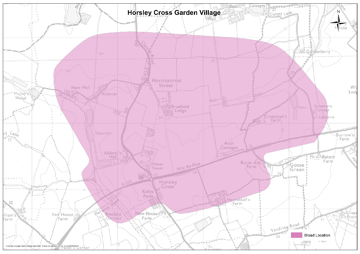
9.44Horsley Cross is the third of three locations identified for the establishment of a new Garden Village along with Hare Green and Weeley. The benefits of Horsley Cross as a location for a new Garden Village include its proximity to both new and potential future centres of employment activity; the availability of relatively flat and unconstrained land; and the potential for large-scale development to be achieved with very limited impacts on the character and amenities of existing established communities.
9.45Its location on the A120 with relatively close proximity to the jobs, shops, services and facilities in Colchester, the proposed Tendring Colchester Borders Garden Community and Manningtree, Lawford and Mistley (and the potential to improve public transport and rapid transport links to those opportunities) also brings the potential to meet some of the significant demand for new housing in the north west of the District which the Manningtree, Lawford and Mistley area is too physically constrained to meet. Development at Horsley Cross also has the potential to facilitate and help fund upgrades to the A120 to support Freeport East, the delivery of long-term port expansion at Bathside Bay and the wider objectives for economic growth and job creation in the District.
9.46To ensure the development of the new Garden Village is comprehensively planned from the outset, is served by the necessary infrastructure at the right time and does not prejudice either the operation of the A120 or the delivery of the Tendring Colchester Borders Garden Community, the development will be led through the preparation of a Masterplan and a separate Development Plan Document (DPD). The Council will also impose restrictions, either through the DPD, planning conditions or legal obligations, to ensure that no new homes at the new Garden Village are occupied until the Rapid Transit System serving the Tendring Colchester Borders Garden Community has been extended from the Colchester Park and Ride to connect to Horsley Cross with either direct or indirect connections to Manningtree station and Bathside Bay in Harwich.
9.47The new Garden Village will be expected to embrace the ‘Garden Community Principles’ established through the planning and delivery of the Tendring Colchester Borders Garden Community. Policy SAMU9 below therefore outlines these expectations, in a similar way to how they were set out in the Council’s previous Local Plan in respect of the Tendring Colchester Borders Garden Community. All development forming part of the new Horsley Cross Garden Village will therefore be expected to comply with these principles:
- Community and stakeholder participation in the design and delivery of the Garden Village from the outset and a long-term community engagement and activation strategy.
- The public sector working pro-actively and collaboratively with the private sector to design, and bring forward the Garden Village, deploying new models of delivery where appropriate and ensuring that the cost of achieving the following is borne by landowners and those promoting the developments: (a) securing a high-quality of place-making, (b) ensuring the timely delivery of both on-site and off-site infrastructure required to address the impact of the new community, and (c) providing and funding a mechanism for future stewardship, management, maintenance and renewal of community infrastructure and assets. Where appropriate, developers will be expected to contribute towards any publicly funded infrastructure. Given the scale of and time period for development of the new Garden Village, the appropriate model of delivery will need to secure a comprehensive approach to delivery in order to achieve the outcomes outlined in points (a) - (c) above, avoid a piecemeal approach to development, provide the funding and phasing of both development and infrastructure, and be sustainable and accountable in the long term.
- Promotion and execution of the highest quality of planning, design and management of the built and public realm so that the Garden Village is characterised as a distinctive place that capitalises on local assets, respects its context, and establishes an environment that promotes health, happiness and well-being.
- Sequencing of development and infrastructure provision (both on-site and off-site) to ensure that the latter is provided ahead of or in tandem with the development it supports to address the impacts of the new Garden Village, meet the needs of its residents, to protect the amenity of nearby established communities and establish sustainable travel patterns. To ensure new development does not have an adverse effect on any European Protected or nationally important sites and complies with environmental legislation (notably the Water Framework Directive and the Habitats Directive), the required wastewater treatment capacity must be available ahead of the occupation of dwellings.
- Development that provides for a truly balanced and inclusive community and meets the housing needs of local people including a mix of dwelling sizes, tenures and types, provision for self- and custom-built homes, provision for the aging population; and provision for Gypsies and Travellers; and that meets the requirements of those most in need including the provision of affordable housing in the Garden Village.
- Provide and promote opportunities for employment within the new Garden Village and within sustainable commuting distance of it.
- Plan the new community around a step change in integrated and sustainable transport systems for the wider area that put walking, cycling and rapid public transit networks and connections at the heart of growth, encouraging and incentivising more sustainable active travel patterns.
- Design the new community to create sociable, vibrant and walkable neighbourhoods with equality of access for all to a range of community services and facilities including health, education, retail, culture, community meeting spaces, multi-functional open space, sports and leisure facilities.
- Develop specific parking approaches and standards that help promote the use of sustainable transport and make efficient use of land.
- Create distinctive environments based on comprehensive assessments of the surrounding environment that celebrate natural and historic environments and systems; utilise a multi-functional green-grid to create significant, connected networks of new green infrastructure including a new country park at the garden community; provide a high degree of connectivity to existing corridors, networks, and assets; and enhance biodiversity.
- Secure a smart and sustainable approach that fosters climate resilience and a 21st century environment in the design and construction of the garden community to secure net gains in local biodiversity, highest standards of energy efficiency and innovation in technology to reduce the impact of climate change, the incorporation of innovative water efficiency/re-use measures (with the aim of being water neutral in areas of serious water stress), and sustainable waste and mineral management.
- Ensure that the costs and benefits of developing the Garden Village are shared by all landowners, with appropriate measures being put in place to equalise the costs and land contributions.
- Consideration of potential on-site mineral resources through a Minerals Resource Assessment as required by the Minerals Planning Authority.
- Establishment at an early stage in the development of the Garden Village, of appropriate and sustainable long-term governance and stewardship arrangements for community assets.
9.48Whilst it is proposed that the new Garden Village could start delivering new homes from 2033 and could contribute between 1,500 and 2,000 new homes towards housing delivery in the District before 2042, the Council will keep the trajectory for development under review through annual updates to its Strategic Housing Land Availability Assessment (SHLAA) and if it becomes apparent, for whatever reason, progress is delayed and necessary timescales are not being met in order to achieve the planned rate of development; alternative or interim measures could be considered and incorporated into the Local Plan when it is next reviewed.
9.49Because the Horsley Cross Garden Village is likely to be a long-term development of strategic significance, its inclusion in the Tendring District Local Plan will likely feature as a proposal in the future Spatial Development Strategy (SDS) for Greater Essex to be produced by the new Mayoral County Combined Authority (MCCA). Being a strategic proposal in the SDS will ensure the development is recognised as being of sub-regional importance, with the opportunity for assistance around delivery and funding for infrastructure channelled through the new powers that will be devolved from central government to the future Mayor.
DEVELOPMENT OF HORSLEY CROSS GARDEN VILLAGE
Land at Horsley Cross on the interchange of the A120 and B1035, is identified as the location for a new ‘Garden Village’ to be delivered within the broad area shown on Map SAMU7. The Horsley Cross Garden Village will create a new community that will deliver up to 6,000 new homes, provision of suitably located Gypsy and Traveller accommodation to meet identified needs and 50-60 hectares of employment land in total – of which a proportion could potentially be built up to 2042, with the remainder continuing longer-term into future plan periods.
The Garden Village will be holistically and comprehensively planned with a distinct identity that responds directly to its context and of a scale sufficient to incorporate a range of homes, employment, education & community facilities, green space and other uses to enable residents to meet the majority of their day-to-day needs. It will be comprehensively planned from the outset, with delivery phased to achieve the whole development, and will be underpinned by a comprehensive package of infrastructure.
A Development Plan Document (DPD) will be prepared for the Garden Village, containing policies setting out how the new community will be designed, developed and delivered in phases. No planning consent for development forming part of the new Garden Village will be granted until the DPD has been adopted.
The DPD will define the boundary of the new Garden Village and the amount of development it will contain. It will be produced in consultation with the local community and stakeholders and will include a concept plan showing the disposition and quantity of future land-uses, and give a three dimensional indication of the urban design and landscape parameters which will be incorporated into any future planning applications; together with a phasing and implementation strategy which sets out how the rate of development will be linked to the provision of the necessary social, physical and environmental infrastructure to ensure that the respective phases of the development do not come forward until the necessary infrastructure has been secured.
The DPD and any planning application will address the principles set out in i-xiv of the supporting text above, along with all of the following principles and requirements for the design, development and delivery of the new Garden Village:
A. Place-Making and Design Quality
- The development of the new Garden Village will be built to high standards of design and layout, drawing on its context and set within a strong green framework with a new neighbourhood centre at its heart. It will be designed and developed to have its own identity and be as self-sustaining as possible recognising its location close to neighbouring towns, villages and hamlets, and potential for connectivity to the future Tendring Colchester Borders Garden Community, Colchester and Manningtree, Lawford and Mistley. It will secure appropriate internal and external walking and cycling links along with and rapid public transport connections that enable residents to have convenient access to nearby settlements and the new services and facilities provided at the Tendring Colchester Borders Garden Community and Hare Green Garden Village. Sustainable transport must be maximised to mitigated the impact of the new development on the highway network and embed healthy living opportunities for new and existing communities. Clear separation will be maintained between the new Garden Village and the communities within the Parishes of Tendring and Bradfield through the designation of Strategic Green Gaps, and the hamlet of Horsleycross Street through the strategic location of open space and landscaping buffers.
- Detailed masterplans and design guidance, based on a robust assessment of historic and natural environmental constraints and opportunities for enhancement, will be adopted to inform and guide development proposals and planning applications for the Garden Village.
B. Housing
- A mix of housing types and tenures including self- and custom-build and starter homes will be provided on the site, including 30% affordable housing and will be phased throughout the development.
- New residential development will seek to achieve appropriate densities which reflect both context, place-making aspirations and opportunities for increased levels of development around the neighbourhood centre.
C. Gypsy and Traveller Accommodation
- Provision of suitably located Gypsy and Traveller accommodation, capable of providing appropriate and good quality accommodation to meet identified needs.
D. Employment and Jobs
- The Garden Village will make provision for a range of jobs, skills and training opportunities. Through Policy PPL7, this Local Plan allocates 14 hectares of land northwest of the Horsley Cross roundabout for B use employment land to help meet projected needs up to 2042 and the DPD will make provision for additional employment land for longer-term expansion southeast of the roundabout which could extend to a further 40-50 hectares. These sites may include provision for light industrial and/or other employment generating uses and provision for office, research & development, industrial, storage and distribution. Employment areas will be designed to ensure excellent accessibility via sustainable transport options, prioritising safe, direct, and convenient routes for walking, wheeling, and cycling.
- High speed broadband will be provided across the site, and the design of homes will make provision for working from home.
E. Transportation
- A package of measures will be introduced to encourage smarter transport choices to meet the needs of the new community and to maximise the opportunities for sustainable travel. No new homes forming part of the Garden Village will be occupied until:
- An additional connection to the Rapid Transit System (RTS) serving the Tendring Colchester Borders Garden Community has been made to Horsley Cross, and the system is operational – with either an extended RTS or a connected frequent bus service both to Manningtree Station and to Bathside Bay in Harwich; and
- The Park and Choose facility located at the Tendring Colchester Borders Garden Community has been completed and is operational.
Additional transport priorities include the provision of a network of footpaths, cycleways and bridleways to enhance permeability within the site and to access the adjoining areas; and other effective integrated measures to mitigate the transport impacts of the proposed development on the strategic and local road network. Longer term transport interventions will need to be carefully designed to minimise the impacts on the strategic and local transport network and fully mitigate any environmental or traffic impacts arising from the development.
- Primary vehicular access to the site will be provided off new junctions on the B1035. The development must incorporate a suitable and safe single-carriageway route, of a specification agreed with the relevant highways authority, designed to divert mainstream traffic away from the hamlet of Horsleycross Street. This measure should minimise disturbance and safeguard the character of Horsleycross Street as a distinct rural hamlet. Any other highway improvements required to meet needs arising from the Garden Village will be set out in the DPD and further defined as part of the masterplanning process and Transport Assessment.
- Development will be expected to contribute to the delivery of sustainable transport strategies for managing the cumulative impacts of growth directly or through financial contributions, including measures to promote sustainable travel. Transport Statements and Assessments will provide the evidence of how cumulative impacts are being addressed.
- Other specific transport-related infrastructure requirements identified through the Development Plan Document and masterplans for the Garden Village will be delivered in a phased manner. Infrastructure delivery must align with each development phase and will appropriately mitigate the impacts of the development at all phases.
F. Community Infrastructure
- A new neighbourhood centre at the core of the Garden Village of an appropriate scale will be provided to serve the proposed development. The centre will be located where it will be easily accessible by walking, cycling and public transit to residents in the Garden Village.
- Community facilities (in the form of a community building(s) or centre or equivalent) will be provided within the local centre. Buildings should be designed flexibly to ensure they are resilient to respond to the changing needs over time and to ensure they can support a diverse range of uses.
- Increased primary healthcare capacity will be provided to serve the new development. This could be by means of new on-site infrastructure; an improvement, reconfiguration, extension or relocation of existing medical facilities; or through financial contributions to enhance the delivery of health facilities at the Tendring Colchester Borders Garden Community or in Manningtree.
- A new secondary school along with primary schools and early-years facilities will be provided to serve the new development, in accordance with the most up-to-date evidence provided by the Education Authority. Public transport links to existing education facilities must be provided before any dwellings at the new Horsley Cross Garden Village can be occupied, allowing for development to be phased in a way that ensures all children have access to education ahead of the completion of new schools.
- A network of multi-functional green infrastructure will be provided within the garden community incorporating key elements of the existing green assets within the site. It will include a central village green and a country park to the wert, along with community parks, allotments, the provision of well-connected and accessible sports areas with associated facilities and play facilities.
- Indoor leisure and sports facilities will be provided within the new community.
G. Other Requirements
- The delivery of smart, innovative and sustainable water efficiency/re-use solutions that fosters climate resilience and a 21st century approach towards water supply, water and wastewater treatment and flood risk management. This will include the construction of a new Water Recycling Centre to serve the new community that will have to be in place and operational prior to the first occupation of any new dwellings.
- Conserve and where appropriate enhance the significance of heritage assets (including any contribution made by their settings) both within and surrounding the site.
- 20. Avoidance, protection and/or enhancement of biodiversity assets within and surrounding the site with a Biodiversity Net Gain requirement of 20%. Development proposals must be designed to enable and support the priority habitat measures identified in the Strategic Opportunities of the Essex Local Nature Recovery Strategy (LNRS) and make enhancements through Green Infrastructure and Nature based solutions.
- Contributions will be secured towards mitigation measures in accordance with the Essex Coast Recreational disturbance Avoidance and Mitigation Strategy. Wintering bird surveys will be undertaken at the appropriate time of year as part of the DPD preparation to identify any offsite functional habitat. Should any be identified, development must firstly avoid impacts. Where this is not possible, development must be phased to deliver habitat creation and management either on- or off-site to mitigate any significant impacts. Any such habitat must be provided and fully functional before any development takes place which would affect significant numbers of SPA birds.
- Provision of appropriate buffers along strategic road infrastructure to protect new development.
- Provision of appropriate design and infrastructure that incorporates the highest standards of innovation in energy efficiency and technology to reduce impact of climate change, water efficiency (with the aim of being water neutral in areas of serious water stress), and sustainable waste / recycling management facilities.
- Provision of a dedicated community development role, funded by the developer for at least ten years from first occupation, to support resident engagement and effective governance structures.
- Establishment at an early stage in the development of the Garden Village, of appropriate and sustainable long-term governance and stewardship arrangements for community assets including green space, public realm areas and community and other relevant facilities; such arrangements to be funded by the development and include community representation to ensure residents have a stake in the long-term development, stewardship and management of their community.
Strategic Housing Allocations
SAH1 Land at Vicarage Farm Off Main Road and South of A120, Harwich
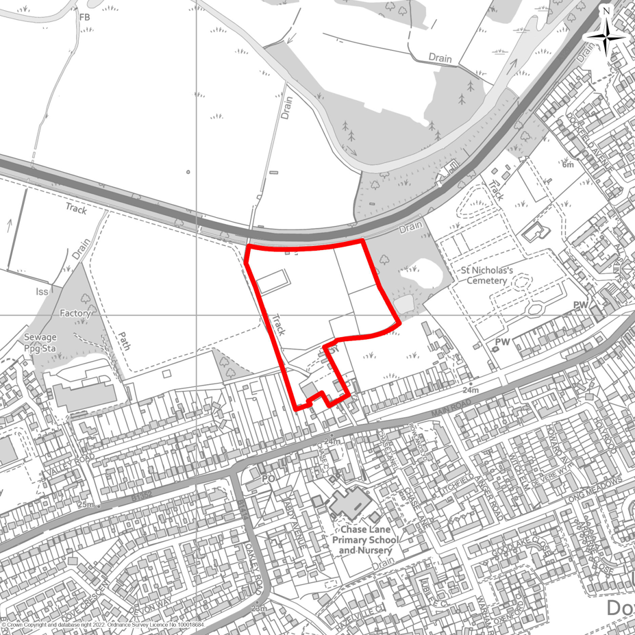
9.50The Land at Vicarage Farm is located to the south of the A120 and to the east of the major mixed-use development known as the Harwich Valley scheme, for which planning permission has already been granted and where construction has commenced. Within this Local Plan, a separate parcel of land previously allocated for employment has now been designated for housing (see Policy MSA1), enabling a wider and more comprehensive residential-led development at the Harwich Valley site. Together, these developments will evolve into a vibrant, sustainably located mixed-use community and serve as an important gateway into Harwich and its international port.
9.51The specific housing allocation at Vicarage Farm will deliver an additional 150 dwellings in a sustainable location, further supporting the significant growth in jobs and housing envisaged for the area. This growth is underpinned by the designation of Freeport East, the advancement of proposals for development at Bathside Bay, and other major opportunities for economic expansion, education and skills, regeneration, and innovation in renewable energy technologies.
9.52The existing planning permission for Harwich Valley to the west, originally granted in 2016, includes provision for a food store of approximately 6,000 square metres, 6,000 square metres of additional retail space for non-food goods, a petrol filling station, a multiplex cinema, restaurants and cafés, a hotel, and a public house. It also incorporates nearly 300 new homes and 6.3 hectares of land for business and industrial uses, providing up to 24,000 square metres of floorspace. Access to the development is to be secured via a new roundabout onto the A120, which has planning approval from National Highways and is already under construction.
9.53This Strategic Allocation for Housing at Vicarage Farm will therefore rely on access through the Harwich Valley development, specifically via the new junction with the A120. Policy SAH1 below sets out the specific requirements for this site. Any planning applications will be expected to comply with, and contribute to, the delivery of these requirements, alongside other relevant policies in the Local Plan.
DEVELOPMENT AT VICARAGE FARM OFF MAIN ROAD AND SOUTH OF A120, HARWICH
Vicarage Farm, Harwich/Dovercourt, as shown on Map SAH1, is allocated for residential development. The site shall deliver:
- A minimum of 150 new dwellings of mixed size and type, including affordable housing in accordance with the Council’s requirements under policy LP5. The development must be compatible with the character and scale of surrounding properties;
- Provision of public open space in accordance with Policy HP5, designed to serve both new residents and the wider community;
Development Requirements
Proposals must demonstrate compliance with the following criteria:
Access and Movement
- The site must provide safe and suitable vehicular, pedestrian and cycle access via the Harwich Valley development and its new roundabout junction with the A120, that meets required highway design standards. Any planning submission needs to provide clear evidence that the proposal will not adversely affect highway capacity or safety;
- Development must incorporate safe and inclusive pedestrian and cycle access throughout the site, with a permanent, clear and legible pedestrian and cycle connection to the south via Main Road/The Green. Proposals must demonstrate how pedestrian routes will integrate with existing footways along Main Road/The Green (to the south) to improve the sustainability credentials of any development. Schemes should also seek to incorporate green infrastructure corridors that support recreational access to the countryside and promote active travel;
Landscape and Visual Impact
- The development must be compatible with the character and scale of surrounding properties. The design must give specific consideration to the site’s topography, ensuring that layout and form respond appropriately to natural land features;
- The layout and design must retain and enhance existing site features of ecological or amenity value. Where such features are present, the applicant must follow a hierarchy of avoidance, mitigation, and compensation for any adverse impacts;
- Screening measures, such as locally appropriate tree belts and/or hedgerows, must be provided along site boundaries and elsewhere within the site (where required) to ensure the development is sensitively integrated into the surrounding landscape;
Biodiversity, Ecology and Flood Risk Mitigation
- A requirement for 20% biodiversity net gain including the improvement of existing hedgerow conditions. Development proposals must be designed to enable and support the priority habitat measures identified in the Strategic Opportunities of the Essex Local Nature Recovery Strategy (LNRS);
- The applicant must demonstrate adequate wastewater capacity, including any necessary phasing or alternative solutions, to the satisfaction of both the Council and Anglian Water;
- Surface water must be attenuated and discharged to an on-site receiving waterbody, not to the combined sewer network, unless it can be robustly demonstrated that no alternative option exist;
- Development must not result in any increase in flood risk either on-site or to adjacent land. Surface water drainage strategies should be designed to ensure that runoff rates and volumes are controlled to pre-development levels or better, with consideration given to sustainable drainage systems (SuDS) where feasible;
- In addition to prioritising SuDS and water efficiency measures, the development must include a range of actions to reduce pressure on the Water Recycling Centre, such as:
- Removal of unnecessary network flows;
- Targeted education initiatives for new residents;
- Measures to reduce demand for potable water.
- Prior to planning approval, wintering bird surveys must be carried out at the appropriate time of year to identify any offsite functional habitat. If significant numbers of SPA birds are found, the development must first seek to avoid impacts. Where avoidance is not possible, the scheme must be phased to deliver habitat creation and management, either on-site or off-site, to mitigate any significant effects. Such habitat must be fully functional before any development that could affect SPA birds is permitted to proceed.
Infrastructure Contributions
- The development must deliver any site-specific infrastructure requirements identified in the Infrastructure Delivery Plan, which may include education provision, highway improvements, water and wastewater infrastructure, and community or open space facilities.
SAH2 Land North of Thorpe Road, Kirby Cross
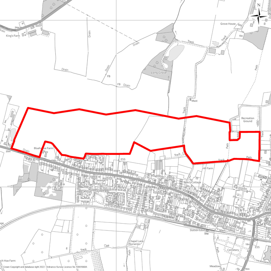
9.54Policy SAH2 below sets out the specific requirements for this development site. Any planning applications will be expected to comply with, and contribute to, the delivery of these requirements, alongside other relevant policies in the Local Plan.
9.55The Council will work collaboratively with the landowner, developers, and other partners, in consultation with the local community, to ensure that the development is delivered in a way that generates economic, social, and environmental benefits for both the local community and the wider district.
9.56A Transport Assessment must accompany any planning application to identify suitable means of access along Thorpe Road. Where necessary, this will include appropriate highway capacity and safety enhancements, improvements to public transport services and infrastructure, and upgrades to cycle, pedestrian, and bridleway networks.
9.57The Council will also work with Network Rail, bus and train operators, and developers to explore opportunities for improvements at Kirby Cross station. These may include enhanced facilities, increased service frequency, better interchange between bus and rail transport, and support for development around the station that would help facilitate these improvements.
DEVELOPMENT NORTH OF THORPE ROAD, KIRBY CROSS
Land north of Thorpe Road, Kirby Cross, shown on the Map SAH2 is allocated for residential development. The site shall deliver:
- a minimum of 420 new dwellings comprising a mix of sizes and types, including affordable housing in accordance with the Council’s requirements as set out in policy LP5;
- Public open space as required by Policy HP5, with consideration given to how this integrates with and enhances the existing playing fields and sporting facilities at Kirby Playing Fields.
Development Requirements
Proposals must comply with the following criteria:
Access and Movement
- The principal vehicular access shall be taken from Thorpe Road, at the point where the site adjoins the highway along its south-western boundary;
- Where necessary, appropriate improvements to the capacity and/or safety of the local highway network shall be delivered to support the development;
- Enhancements to public transport provision shall be secured where required, alongside improved pedestrian and cycle connectivity between the site, public transport nodes, Kirby Playing Fields, and the wider existing active travel network, including bridleways;
Landscape, Visual Impact and Amenity
- The design and layout of the development must respond sensitively to the surrounding landscape including the amenity of nearby residents, especially the residential occupiers to the south, incorporating mitigation measures to minimise visual impact and reinforce local character;
- The development must retain and enhance existing site features of ecological or amenity value. Where such features are present, the applicant must follow a hierarchy of avoidance, mitigation, and compensation for any adverse impacts;
- Screening measures, such as locally appropriate tree belts and/or hedgerows, must be provided along site boundaries and elsewhere within the site (where required) to ensure the development is sensitively integrated into the surrounding landscape;
Heritage
- The development must conserve, and where appropriate, enhance the significant and setting of the nearby Grade II Listed Blue House Farmhouse.
Biodiversity, Ecology and Flood Risk Mitigation
- A requirement for 20% biodiversity net gain including the improvement of existing hedgerow conditions. Development proposals must be designed to enable and support the priority habitat measures identified in the Strategic Opportunities of the Essex Local Nature Recovery Strategy (LNRS);
- The applicant must demonstrate adequate wastewater capacity, including any necessary phasing or alternative solutions, to the satisfaction of both the Council and Anglian Water;
- Surface water must be attenuated and discharged to an on-site receiving waterbody, not to the combined sewer network, unless it can be robustly demonstrated that no alternative option exist;
- Development must not result in any increase in flood risk either on-site or to adjacent land. Surface water drainage strategies should be designed to ensure that runoff rates and volumes are controlled to pre-development levels or better, with consideration given to sustainable drainage systems (SuDS) where feasible;
- In addition to prioritising SuDS and water efficiency measures, the development must include a range of actions to reduce pressure on the Water Recycling Centre, such as:
- Removal of unnecessary network flows;
- Targeted education initiatives for new residents;
- Measures to reduce demand for potable water.
Infrastructure Contributions
- The development must deliver any site-specific infrastructure requirements identified in the Infrastructure IDP, which may include education provision, highway improvements, water and wastewater infrastructure, and community or open space facilities.
SAH3 Land off Arthur Ransome Way, Walton
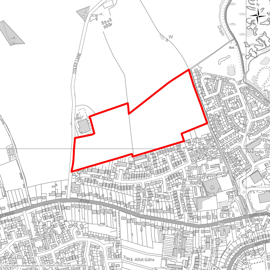
9.58Policy SAH3 sets out the specific requirements for this development site. Any planning applications will be expected to comply with, and contribute to, the delivery of these requirements, alongside other relevant policies in the Local Plan.
9.59The Council will work collaboratively with the landowner, developers, and other partners, in consultation with the local community, to ensure the development is delivered in a way that provides economic, social, and environmental benefits for both the local community and the wider district.
9.60A Transport Assessment must accompany any planning application to establish suitable means of access. Where necessary, this will include measures to enhance highway capacity and safety, improve public transport services and infrastructure, and upgrade cycle, pedestrian, and bridleway networks.
9.61The Council will also work with Network Rail, bus and train operators, and developers to explore opportunities for improvements at Walton-on-the-Naze station. Potential enhancements may include upgraded facilities, increased service frequency, improved interchange between bus and rail transport, and support for development around the station that would help facilitate these improvements.
DEVELOPMENT OF LAND OFF ARTHUR RANSOME WAY, WALTON
Land off Arthur Ransome Way, Walton, as shown on Map SAH3, is allocated for residential development. The site shall deliver:
- Up to 200 new dwellings of mixed size and type, including affordable housing in accordance with the Council’s requirements as set out in policy LP5;
- Provision of public open space as required by Policy HP5, designed to serve both new residents and the wider community.
Development Requirements
Proposals must demonstrate compliance with the following criteria:
Access and Movement
- The site must provide safe and suitable access that meets required highway design standards. The location of vehicle access must be agreed with the Highway Authority, with clear evidence that the proposal will not adversely affect highway capacity or safety;
- The development must incorporate safe pedestrian access to ensure connectivity within the site and to existing footways and where possible, any nearby Public Rights of Way. Where feasible, the scheme should include green infrastructure links, recreational access to the countryside, and active travel connections to the wider settlement of Walton and Walton-on-the-Naze station.
Landscape and Visual Impact
- The development must be compatible with the character and scale of surrounding properties. The design must give specific consideration to the site’s topography, ensuring that layout and form respond appropriately to natural land features;
- The layout and design must retain and enhance existing site features of ecological or amenity value. Where such features are present, the applicant must follow a hierarchy of avoidance, mitigation, and compensation for any adverse impacts;
- Screening measures, such as locally appropriate tree belts and/or hedgerows, must be provided along site boundaries and elsewhere within the site (where required) to ensure the development is sensitively integrated into the surrounding landscape;
Biodiversity, Ecology and Flood Risk Mitigation
- A requirement for 20% biodiversity net gain including the improvement of existing hedgerow conditions. Development proposals must be designed to enable and support the priority habitat measures identified in the Strategic Opportunities of the Essex Local Nature Recovery Strategy (LNRS);
- The applicant must demonstrate adequate wastewater capacity, including any necessary phasing or alternative solutions, to the satisfaction of both the Council and Anglian Water;
- Surface water must be attenuated and discharged to an on-site receiving waterbody, not to the combined sewer network, unless it can be robustly demonstrated that no alternative option exist;
- Development must not result in any increase in flood risk either on-site or to adjacent land. Surface water drainage strategies should be designed to ensure that runoff rates and volumes are controlled to pre-development levels or better, with consideration given to sustainable drainage systems (SuDS) where feasible;
- In addition to prioritising SuDS and water efficiency measures, the development must include a range of actions to reduce pressure on the Water Recycling Centre, such as:
- Removal of unnecessary network flows;
- Targeted education initiatives for new residents;
- Measures to reduce demand for potable water
- Prior to planning approval, wintering bird surveys must be carried out at the appropriate time of year to identify any offsite functional habitat. If significant numbers of SPA birds are found, the development must first seek to avoid impacts. Where avoidance is not possible, the scheme must be phased to deliver habitat creation and management, either on-site or off-site, to mitigate any significant effects. Such habitat must be fully functional before any development that could affect SPA birds is permitted to proceed.
Infrastructure Contributions
- The development must deliver any site-specific infrastructure requirements identified in the Infrastructure Delivery Plan, which may include education provision, highway improvements, water and wastewater infrastructure, and community or open space facilities.
SAH4 Land East of Church Road, Brightlingsea
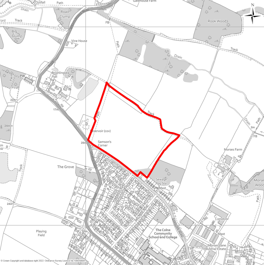
9.62Policy SAH4 sets out the specific requirements for this site. The northern and north-western edges of Brightlingsea are largely free from significant physical or environmental constraints, making this area the most suitable location for strategic housing growth.
9.63In addition to delivering a mix of new homes, the development will provide new public open spaces designed for both future residents and the wider community. The layout and design will respond sensitively to the surrounding landscape, with particular emphasis on screening and mitigation along the northern boundary, as well as enhancements to the landscape along Church Road and Samsons Road. The increase in households will contribute to economic growth by supporting local spending and investment in Brightlingsea and neighbouring towns and villages.
9.64Any planning application must be accompanied by a Transport Assessment to identify appropriate access arrangements from Samsons Road. Where necessary, this should include improvements to highway capacity and safety, enhancements to public transport services and infrastructure, and upgrades to cycling, pedestrian, and bridleway networks.
9.65Planning applications will be expected to comply with these requirements and other relevant Local Plan policies. The Council will work collaboratively with landowners, developers, and partners—alongside consultation with the local community—to ensure the development delivers economic, social, and environmental benefits for both Brightlingsea and the wider district.
DEVELOPMENT OF LAND EAST OF CHURCH ROAD, BRIGHTLINGSEA
Development Parameters
- Up to 300 dwellings, comprising a mix of sizes and types, including affordable housing in accordance with the Council’s requirements as set out in policy LP5.
- Provision of public open space in accordance with Policy HP5, designed to serve both new residents and the wider community.
Development Requirements
Proposals must demonstrate compliance with the following criteria:
Access and Movement
- The principal vehicular access shall be taken from Samsons Road;
- Where necessary, capacity and/or safety enhancements to the local highway network must be provided; and
- Where necessary, improvements to sustainable transport infrastructure—including public transport, cycling, pedestrian routes, and bridleways—shall be incorporated to promote active travel and improve connectivity.
Landscape and Visual Impact
- The design and layout must respond sensitively to the surrounding landscape character, with particular attention to:
- Screening and mitigation along the northern edge of the site; and
- Landscape enhancement measures along Church Road and Samsons Road
- Development must respect and respond to the topography of the site, ensuring that built form integrates harmoniously with natural landforms.
- The layout and design must retain and enhance existing site features of ecological or amenity value. Where such features are present, the applicant must follow a hierarchy of avoidance, mitigation, and compensation for any adverse impacts;
Heritage
- Preservation of the significance of the Brightlingsea Hall and All Saints Church Conservation Area and the Grade I Listed All Saints Church to the west of the site. This includes careful consideration of their setting, views, and any potential impacts on their historic character and architectural integrity.
Biodiversity, Ecology and Flood Risk Mitigation
- A requirement for 20% biodiversity net gain including the improvement of existing hedgerow conditions. Development proposals must be designed to enable and support the priority habitat measures identified in the Strategic Opportunities of the Essex Local Nature Recovery Strategy (LNRS);
- The applicant must demonstrate adequate wastewater capacity, including any necessary phasing or alternative solutions, to the satisfaction of both the Council and Anglian Water;
- Surface water must be attenuated and discharged to an on-site receiving waterbody, not to the combined sewer network, unless it can be robustly demonstrated that no alternative option exist;
- Development must not result in any increase in flood risk either on-site or to adjacent land. Surface water drainage strategies should be designed to ensure that runoff rates and volumes are controlled to pre-development levels or better, with consideration given to sustainable drainage systems (SuDS) where feasible;
- In addition to prioritising SuDS and water efficiency measures, the development must include a range of actions to reduce pressure on the Water Recycling Centre, such as:
- Removal of unnecessary network flows;
- Targeted education initiatives for new residents;
- Measures to reduce demand for potable water.
Infrastructure Contributions
- The development must deliver any site-specific infrastructure requirements identified in the Infrastructure Delivery Plan, which may include education provision, highway improvements, water and wastewater infrastructure, and community or open space facilities.
SAH6 Land east of Cockaynes Lane, Alresford
9.66Further expansion of Alresford to the northwest, beyond the most recent development at Cockaynes Lane, represents the most appropriate and sustainable option for accommodating growth within the settlement. PolicySAH6 sets out the detailed requirements for this allocation. Any planning application for this site must demonstrate compliance with these requirements and contribute to their delivery, alongside other relevant policies within the Local Plan.
9.67The Council will work proactively and collaboratively with the landowner, the adjacent landowner to the north-east, developers, statutory bodies, and the local community to ensure that this development, together with the neighbouring Medium Site Allocation, is delivered in a coordinated, integrated, and holistic manner. This approach will secure economic, social, and environmental benefits for Alresford and the wider district.
9.68A comprehensive Transport Assessment will be required to accompany any planning application. This should identify suitable access arrangements and, where necessary, include measures to enhance highway capacity and safety, improve public transport provision and infrastructure, and upgrade walking, cycling, and bridleway networks.
9.69The Council will also engage with Network Rail, bus and train operators, and developers to explore opportunities for improvements at Alresford Station. Potential enhancements may include upgraded passenger facilities, increased service frequency, improved interchange between bus and rail, and support for complementary development around the station to help facilitate these improvements.
DEVELOPMENT OF LAND EAST OF COCKAYNES LANE, ALRESFORD
Land east of Cockaynes Lane, as shown on Map SAH6, is allocated for residential development. The site shall deliver:
- Up to 100 new dwellings of mixed size and type, with a focus on provision of housing for the ageing population and opportunities for self-build development, and affordable housing in accordance with the Council’s requirements as set out in Policy LP5 and having regard to the policies contained within the Alresford Neighbourhood Plan;
- Provision of public open space in accordance with Policy HP5, designed to serve both new residents and the wider community.
Development Requirements
Proposals must demonstrate compliance with the following criteria:
Access and Movement
- The development must demonstrate the provision of safe, suitable, and deliverable access arrangements in accordance with adopted highway design standards. The location and design of vehicular access points must be agreed in consultation with the Highway Authority and supported by clear evidence that the scheme will not result in unacceptable impacts on highway safety, capacity, or efficiency, whilst having regard to the neighbouring Medium Site Allocation to the north-west. Where mitigation is necessary to ensure safe and suitable access for vehicles and pedestrians, such measures must be fully integrated into the design of the development. These measures must be secured through appropriate legal mechanisms, such as planning obligations or conditions, to ensure their delivery and long-term effectiveness;
- The development must incorporate safe pedestrian access to ensure connectivity within the site, to the neighbouring Medium Site Allocation (see MSA7) and to existing footways in the vicinity of the site, and any nearby Public Rights of Way. Where feasible, the scheme should include green infrastructure links, recreational access to the countryside, and active travel connections to the wider settlement of Alresford.
Landscape and Visual Impact
- The development must adopt a coordinated and holistic design approach, ensuring a comprehensive and well-integrated scheme in close collaboration with the neighbouring Medium Site Allocation for 40 dwellings (see MSA7 below). Particular attention should be given to the site’s topography, with the layout and built form responding sensitively to natural land features and creating a seamless relationship between the two sites;
- The layout and design must retain and enhance existing site features of ecological or amenity value. Where such features are present, the applicant must follow a hierarchy of avoidance, mitigation, and compensation for any adverse impacts;
- Screening measures, such as locally appropriate tree belts and/or hedgerows, must be provided along site boundaries and elsewhere on the site (where required) to ensure the development is sensitively integrated into the surrounding landscape;
Biodiversity, Ecology and Flood Risk Mitigation
- A requirement for 20% biodiversity net gain including the improvement of existing hedgerow conditions. Development proposals must be designed to enable and support the priority habitat measures identified in the Strategic Opportunities of the Essex Local Nature Recovery Strategy (LNRS);
- The applicant must demonstrate adequate wastewater capacity, including any necessary phasing or alternative solutions, to the satisfaction of both the Council and Anglian Water;
- Surface water must be attenuated and discharged to an on-site receiving waterbody, not to the combined sewer network, unless it can be robustly demonstrated that no alternative option exist;
- Development must not result in any increase in flood risk either on-site or to adjacent land. Surface water drainage strategies should be designed to ensure that runoff rates and volumes are controlled to pre-development levels or better, with consideration given to sustainable drainage systems (SuDS) where feasible;
- In addition to prioritising SuDS and water efficiency measures, the development must include a range of actions to reduce pressure on the Water Recycling Centre, such as:
- Removal of unnecessary network flows;
- Targeted education initiatives for new residents;
- Measures to reduce demand for potable water.
Infrastructure Contributions
- The development must deliver any site-specific infrastructure requirements identified in the Infrastructure Delivery Plan, which may include education provision, highway improvements, water and wastewater infrastructure, and community or open space facilities.
SAH7 Land east of Admirals Green and north of Weeley Road, Great Bentley
9.70This peripheral area of Great Bentley is largely unconstrained by significant physical or environmental limitations, making it the most appropriate location for strategic housing growth. Its suitability is further reinforced by recent development on the opposite side of Weeley Road. Policy SAH7 sets out the detailed requirements for this allocation, and any planning application must demonstrate full compliance with these requirements alongside other relevant Local Plan policies.
9.71In addition to delivering a balanced mix of new homes, the development will provide high-quality public open spaces designed to benefit both new residents and the wider community. The layout and design will respond sensitively to the surrounding landscape character, incorporating robust screening and mitigation measures along all site boundaries, together with landscape enhancements along Weeley Road and the entire eastern edge of the site. The increase in households resulting from this allocation will help stimulate economic growth, supporting local businesses and services in Great Bentley and contributing to wider investment across nearby towns and villages.
9.72The Council will work collaboratively with the landowner, developers, and key stakeholders, in consultation with the local community, to ensure the development delivers economic, social, and environmental benefits for both Great Bentley and the wider district.
9.73A comprehensive Transport Assessment will be required to accompany any planning application. This must identify suitable access arrangements from Weeley Road and, where necessary, include measures to improve highway capacity and safety, enhance public transport services and infrastructure, and upgrade walking, cycling, and bridleway networks.
9.74The Council will also engage with Network Rail, bus and train operators, and developers to explore opportunities for improvements at Great Bentley Station. Potential enhancements may include upgraded passenger facilities, increased service frequency, improved interchange between bus and rail, and support for complementary development around the station to help deliver these improvements.
DEVELOPMENT OF LAND EAST OF ADMIRALS GREEN AND NORTH OF WEELEY ROAD. GREAT BENTLEY
Land east ofeast of Admirals Green and north of Weeley Road, as identified on Map SAH7, is allocated for residential development. The site shall deliver:
- Up to 120 new dwellings of varied size and type, including affordable housing in accordance with the Council’s adopted requirements as set out in policy LP5;
- Provision of public open space in accordance with Policy HP5 incorporating community sports facilities, designed to serve both new residents and the wider community;
Development Requirements
Proposals must demonstrate compliance with the following criteria:
Access and Movement
- Provision of safe and suitable vehicular access designed to meet highway standards, with the principal access point off Weeley Road. Proposals must demonstrate no adverse impact on highway capacity or safety;
- Delivery of necessary improvements to the local highway network to address capacity, access and/or safety concerns;
- Where appropriate, enhancements to public transport services. Proposals must also provide safe and accessible pedestrian and cycle routes throughout the site, ensuring integrated connectivity to existing footways and Public Rights of Way;
- Integration of green infrastructure to facilitate recreational access to the countryside and promote active travel, with improved links to the wider settlement.
Landscape and Visual Impact
- The development must be compatible with the character and scale of surrounding properties. The design must give specific consideration to the site’s topography, ensuring that layout and form respond appropriately to natural land features;
- The layout and design must retain and enhance existing site features of ecological or amenity value. Where such features are present, the applicant must follow a hierarchy of avoidance, mitigation, and compensation for any adverse impacts;
- Screening measures, such as locally appropriate tree belts and/or hedgerows, must be provided along site boundaries and elsewhere within the site (where required) to ensure the development is sensitively integrated into the surrounding landscape;
Biodiversity, Ecology and Flood Risk Mitigation
- A 20% biodiversity net gain including improved hedgerow management and the creation of grassland habitats along road verges. Development proposals must be designed to enable and support the priority habitat measures identified in the Strategic Opportunities of the Essex Local Nature Recovery Strategy (LNRS);
- The applicant must demonstrate adequate wastewater capacity, including any necessary phasing or alternative solutions, to the satisfaction of both the Council and Anglian Water;
- Surface water drainage must be attenuated and discharged to an appropriate receiving waterbody. Connection to the combined sewer network will only be permitted where no alternative solution exists;
- Development must not result in any increase in flood risk either on-site or to adjacent land. Surface water drainage strategies should be designed to ensure that runoff rates and volumes are controlled to pre-development levels or better, with consideration given to sustainable drainage systems (SuDS) where feasible;
- In addition to prioritising SuDS and water efficiency measures, the development must include a range of actions to reduce pressure on the Water Recycling Centre, such as:
- Removal of unnecessary network flows;
- Targeted education initiatives for new residents;
- Measures to reduce demand for potable water.
Infrastructure Contributions
- Delivery of any site-specific infrastructure identified in the Infrastructure Delivery Plan (IDP), which may include education provision, highway mitigation, water and wastewater infrastructure, and community/open space facilities.
SAH8 Land East of Amerells Road, Little Clacton
9.75Policy SAH8 below sets out the detailed requirements for this allocation, and any planning application must demonstrate full compliance with these requirements alongside other relevant Local Plan policies.
9.76In addition to delivering a balanced mix of new homes, the development will provide high-quality public open spaces designed to benefit both new residents and the wider community. The layout and design will respond sensitively to the surrounding landscape character, incorporating robust screening and mitigation measures along the northern edge of the site. It will also include landscape enhancements and ensure strong pedestrian and cycle permeability, creating an east–west connection between Amerells Road and Grove Road, as well as a link to Feverills Road to the south.
9.77The increase in households resulting from this allocation will help stimulate economic growth, supporting local businesses and services in Little Clacton and contributing to wider investment across nearby towns and villages.
9.78A comprehensive Transport Assessment will be required to accompany any planning application. This must identify suitable access arrangements from Amerells Road and, where necessary, include measures to improve highway capacity and safety, enhance public transport services and infrastructure, and upgrade walking, cycling, and bridleway networks.
9.79The Council will work collaboratively with the landowner, developers, and key stakeholders, in consultation with the local community, to ensure the development delivers economic, social, and environmental benefits for both Little Clacton and the wider district.
DEVELOPMENT OF LAND EAST OF AMERELLS ROAD, LITTLE CLACTON
Land to the East of Amerells Road, as shown on Map SAH8, is allocated for residential development. The site shall deliver:
- Up to 100 new dwellings of mixed size and type, including affordable housing in accordance with the Council’s requirements as set out in policy LP5.
- Provision of public open space in accordance with Policy HP5, designed to serve both new residents and the wider community.
Development Requirements
Proposals must demonstrate compliance with the following criteria:
Access and Movement
- The site must offer safe and appropriate access from Amerells Road, in line with highway design standards, supported by clear evidence that it will not compromise highway capacity or safety;
- The development must incorporate safe pedestrian access to ensure connectivity within the site and to existing footways along Amerells Road. Where feasible, the scheme should include green infrastructure links, recreational access to the countryside, and active travel connections to the wider settlement of Little Clacton.
Landscape and Visual Impact
- The development must be compatible with the character and scale of surrounding properties. The design must give specific consideration to the site’s topography, ensuring that layout and form respond appropriately to natural land features;
- The layout and design must retain and enhance existing site features of ecological or amenity value. Where such features are present, the applicant must follow a hierarchy of avoidance, mitigation, and compensation for any adverse impacts;
- Screening measures, such as locally appropriate tree belts and/or hedgerows, must be provided along site boundaries and elsewhere within the site (where required) to ensure the development is sensitively integrated into the surrounding landscape;
Biodiversity, Ecology and Flood Risk Mitigation
- A 20% biodiversity net gain including improvement of existing hedgerow conditions. Development proposals must be designed to enable and support the priority habitat measures identified in the Strategic Opportunities of the Essex Local Nature Recovery Strategy (LNRS);
- The applicant must demonstrate adequate wastewater capacity, including any necessary phasing or alternative solutions, to the satisfaction of both the Council and Anglian Water;
- Surface water must be attenuated and discharged to an on-site receiving waterbody, not to the combined sewer network, unless it can be robustly demonstrated that no alternative option exist;
- Development must not result in any increase in flood risk either on-site or to adjacent land. Surface water drainage strategies should be designed to ensure that runoff rates and volumes are controlled to pre-development levels or better, with consideration given to sustainable drainage systems (SuDS) where feasible;
- In addition to prioritising SuDS and water efficiency measures, the development must include a range of actions to reduce pressure on the Water Recycling Centre, such as:
- Removal of unnecessary network flows;
- Targeted education initiatives for new residents; and
- Measures to reduce demand for potable water.
Infrastructure Contributions
- The development must deliver any site-specific infrastructure requirements identified in the Infrastructure Delivery Plan, which may include education provision, highway improvements, water and wastewater infrastructure, and community or open space facilities.
SAH9 Land South of Clacton Road, St Osyth
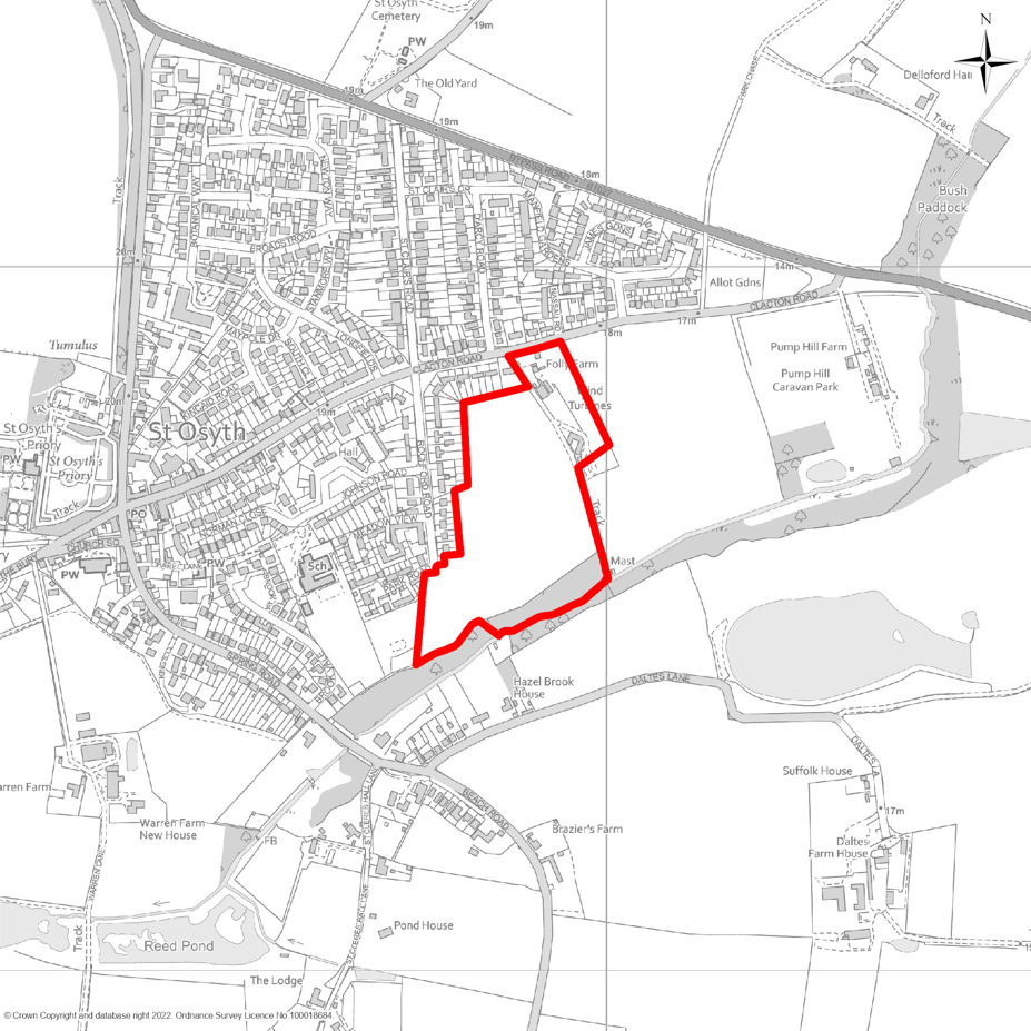
9.80This site offers strong potential for a well-integrated development, benefiting from good connectivity to key local amenities, including the nearby primary school and the village centre to the west. The allocation of 100 new dwellings will deliver a proportionate and sustainable level of growth for St Osyth, consistent with the settlement’s scale and capacity to accommodate new development.
9.81Policy SAH9 sets out the detailed requirements for this allocation, and any planning application must demonstrate full compliance with these requirements alongside other relevant Local Plan policies.
9.82In addition to providing a balanced mix of new homes, the development will incorporate high-quality public open spaces designed to serve both new residents and the wider community. The layout and design will respond sensitively to the surrounding landscape character, with robust screening and mitigation measures along all site boundaries to ensure a well-defined and visually appropriate edge to the settlement. The increase in households resulting from this allocation will help stimulate economic growth, supporting local businesses and services in St Osyth and contributing to wider investment across nearby towns and villages.
9.83A comprehensive Transport Assessment must be submitted with any planning application. This must identify suitable access arrangements and, where necessary, include measures to improve highway capacity and safety, enhance public transport services and infrastructure, and upgrade walking, cycling, and bridleway networks.
9.84The Council will work collaboratively with the landowner, developers, and key stakeholders, in consultation with the local community, to ensure the development delivers economic, social, and environmental benefits for both St Osyth and the wider district.
DEVELOPMENT OF LAND SOUTH OF CLACTON ROAD, ST OSYTH
Land south of Clacton Road, as shown on Map SAH9, is allocated for residential development. The site shall deliver:
- Up to 100 new dwellings of mixed size and type, including affordable housing in accordance with the Council’s requirements as set out in policy LP5.
- Provision of public open space in accordance with Policy HP5, designed to serve both new residents and the wider community.
Development Requirements
Proposals must demonstrate compliance with the following criteria:
Access and Movement
- The site must provide safe and suitable access that meets required highway design standards. The location of vehicle access must be agreed with the Highway Authority, with clear evidence that the proposal will not adversely affect highway capacity or safety;
- The development must incorporate safe pedestrian access to ensure connectivity within the site and to existing footways and where possible, any nearby Public Rights of Way. Where feasible, the scheme should include green infrastructure links, recreational access to the countryside, and active travel connections to the wider settlement of St Osyth.
Landscape and Visual Impact
- The development must be compatible with the character and scale of surrounding properties. The design must give specific consideration to the site’s topography, ensuring that layout and form respond appropriately to natural land features;
- The layout and design must retain and enhance existing site features of ecological or amenity value. Where such features are present, the applicant must follow a hierarchy of avoidance, mitigation, and compensation for any adverse impacts;
- Screening measures, such as locally appropriate tree belts and/or hedgerows, must be provided along site boundaries and elsewhere within the site (where required) to ensure the development is sensitively integrated into the surrounding landscape;
Biodiversity, Ecology and Flood Risk Mitigation
- A 20% biodiversity net gain including the improvement of existing hedgerow conditions. Development proposals must be designed to enable and support the priority habitat measures identified in the Strategic Opportunities of the Essex Local Nature Recovery Strategy (LNRS);
- The applicant must demonstrate adequate wastewater capacity, including any necessary phasing or alternative solutions, to the satisfaction of both the Council and Anglian Water;
- Surface water must be attenuated and discharged to an on-site receiving waterbody, not to the combined sewer network, unless it can be robustly demonstrated that no alternative option exist;
- Development must not result in any increase in flood risk either on-site or to adjacent land. Surface water drainage strategies should be designed to ensure that runoff rates and volumes are controlled to pre-development levels or better, with consideration given to sustainable drainage systems (SuDS) where feasible;
- In addition to prioritising SuDS and water efficiency measures, the development must include a range of actions to reduce pressure on the Water Recycling Centre, such as:
- Removal of unnecessary network flows;
- Targeted education initiatives for new residents; and
- Measures to reduce demand for potable water.
- Prior to planning approval, wintering bird surveys must be carried out at the appropriate time of year to identify any offsite functional habitat. If significant numbers of SPA birds are found, the development must first seek to avoid impacts. Where avoidance is not possible, the scheme must be phased to deliver habitat creation and management, either on-site or off-site, to mitigate any significant effects. Such habitat must be fully functional before any development that could affect SPA birds is permitted to proceed.
Infrastructure Contributions
- The development must deliver any site-specific infrastructure requirements identified in the Infrastructure Delivery Plan, which may include education provision, highway improvements, water and wastewater infrastructure, and community or open space facilities.
SAH10 Land south of Colchester Road, Thorpe-le-Soken
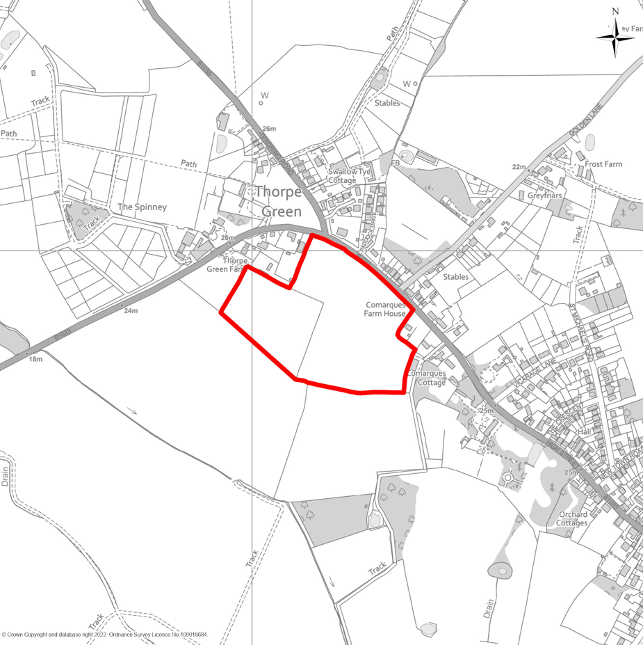
9.85This site, located on the western edge of Thorpe-le-Soken, is largely free from significant physical or environmental constraints, making it a suitable and sustainable location for strategic housing growth. The allocation will deliver a proportionate level of development that aligns with the settlement’s scale and capacity. Policy SAH10 below sets out the detailed requirements for this site, and any planning application must demonstrate full compliance with these requirements alongside other relevant Local Plan policies.
9.86In addition to providing a balanced mix of new homes, the development will incorporate high-quality public open spaces designed to serve both new residents and the wider community. The layout and design will respond sensitively to the surrounding landscape character, including robust screening and mitigation measures along all site boundaries, together with landscape enhancements along Colchester Road and other areas where appropriate. The increase in households resulting from this allocation will help stimulate economic growth, supporting local businesses and services in Thorpe-le-Soken and contributing to wider investment across nearby towns and villages.
9.87A comprehensive Transport Assessment will be required to accompany any planning application. This must identify suitable access arrangements from Colchester Road and, where necessary, include measures to improve highway capacity and safety, enhance public transport services and infrastructure, and upgrade walking, cycling, and bridleway networks.
9.88The Council will work collaboratively with the landowner, developers, and key stakeholders, in consultation with the local community, to ensure the development delivers economic, social, and environmental benefits for both Thorpe-le-Soken and the wider district.
9.89The Council will also engage with Network Rail, bus and train operators, and developers to explore opportunities for improvements at Thorpe-le-Soken Station. Potential enhancements may include upgraded passenger facilities, increased service frequency, improved interchange between bus and rail, and support for complementary development around the station to help deliver these improvements.
DEVELOPMENT OF LAND SOUTH OF COLCHESTER ROAD, THORPE-LE-SOKEN
Land south of Colchester Road, Thorpe-le-Soken, as identified on Map SAH10, is allocated for residential development. The site shall deliver:
- Up to 150 new dwellings, comprising a mix of sizes and types, including affordable housing in accordance with the Council’s requirements as set out in policy LP5;
- Provision of public open space in accordance with Policy HP5, designed to serve both new residents and the wider community.
Development Requirements
Proposals must demonstrate compliance with the following criteria:
Access and Movement
- Provision of safe and suitable vehicular access designed to meet highway standards, with the principal access point in an appropriate location off Colchester Road. Proposals must demonstrate no adverse impact on highway capacity or safety;
- Delivery of necessary improvements to the local highway network to address capacity, access and/or safety concerns;
- Proposals must incorporate measures to enhance public transport provision and strengthen pedestrian and cycle connectivity. These improvements should deliver safe, direct, and convenient links between the site and key destinations, including the settlement of Thorpe-le-Soken to the southeast. Where deemed necessary, pedestrian and cycle connectivity between the site and Thorpe-le-Soken railway station to the south should also be improved.
- Development to include a connection point in the south-eastern part of the site to enable a future spine road link to Station Road and Thorpe-le-Soken railway station to the south-east, ensuring alignment with the wider movement and access strategy;
- Integration of green infrastructure to facilitate recreational access to the countryside and promote active travel;
Landscape and Visual Impact
- The development must be compatible with the character and scale of surrounding properties. The design must give specific consideration to the site’s topography, ensuring that layout and form respond appropriately to natural land features;
- The layout and design must retain and enhance existing site features of ecological or amenity value. Where such features are present, the applicant must follow a hierarchy of avoidance, mitigation, and compensation for any adverse impacts;
- Screening measures, such as locally appropriate tree belts and/or hedgerows, must be provided along site boundaries and elsewhere within the site (where required) to ensure the development is sensitively integrated into the surrounding landscape;
Heritage
- Preservation of the significance of the Thorpe-le-Soken Conservation area to the east of the site, including consideration of its setting;
Biodiversity, Ecology and Flood Risk Mitigation
- A requirement for 20% biodiversity net gain including the improvement of existing hedgerow conditions. Development proposals must be designed to enable and support the priority habitat measures identified in the Strategic Opportunities of the Essex Local Nature Recovery Strategy (LNRS);
- The applicant must demonstrate adequate wastewater capacity, including any necessary phasing or alternative solutions, to the satisfaction of both the Council and Anglian Water;
- Surface water must be attenuated and discharged to an on-site receiving waterbody, not to the combined sewer network, unless it can be robustly demonstrated that no alternative option exist;
- Development must not result in any increase in flood risk either on-site or to adjacent land. Surface water drainage strategies should be designed to ensure that runoff rates and volumes are controlled to pre-development levels or better, with consideration given to sustainable drainage systems (SuDS) where feasible;
- In addition to prioritising SuDS and water efficiency measures, the development must include a range of actions to reduce pressure on the Water Recycling Centre, such as:
- Removal of unnecessary network flows;
- Targeted education initiatives for new residents;
- Measures to reduce demand for potable water.
Infrastructure Contributions
- Delivery of any site-specific infrastructure identified in the Infrastructure Delivery Plan, which may include education provision, highway mitigation, water and wastewater infrastructure, and community/open space facilities.
SAH11 Land North of Lifehouse Spa & Hotel, Thorpe-le-Soken
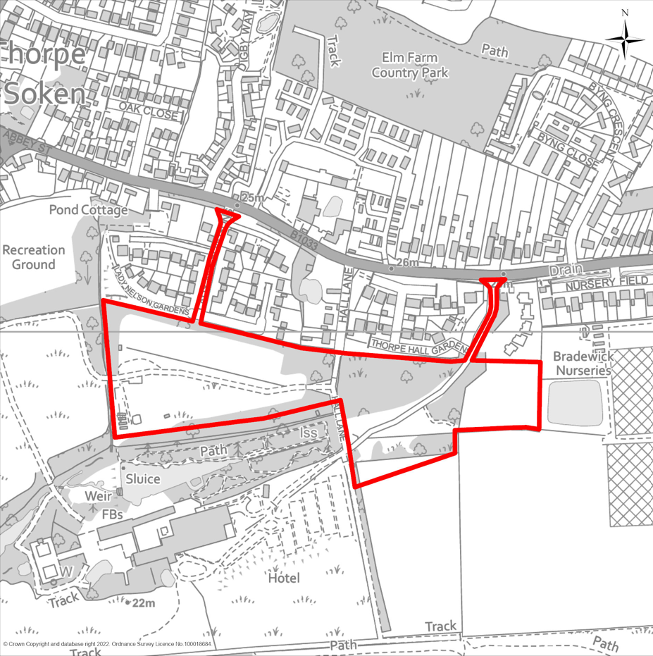
9.90This site benefits from strong connectivity to the established settlement of Thorpe-le-Soken. The allocation offers opportunities to improve safe pedestrian and cycle connections between the site and Thorpe-le-Soken railway station to the south, enhancing sustainable travel choices. The proposed level of development will be proportionate to the settlement’s scale and capacity.
9.91Policy SAH11 below sets out the detailed requirements for this allocation, and any planning application must demonstrate full compliance with these requirements alongside other relevant Local Plan policies.
9.92In addition to delivering a balanced mix of new homes, the development will provide high-quality public open spaces and ensure strong pedestrian and cycle permeability throughout the site. These spaces will be designed to serve both new residents and the wider community. The layout and design will respond sensitively to the surrounding landscape character, incorporating robust screening and mitigation measures along site boundaries, together with appropriate landscape enhancements. The increase in households resulting from this allocation will help stimulate economic growth, supporting local businesses and services in Thorpe-le-Soken and contributing to wider investment across nearby towns and villages.
9.93A comprehensive Transport Assessment will be required to accompany any planning application. This must identify suitable access arrangements from Frinton Road via Lady Nelson Gardens and Lifehouse Drive and, where necessary, include measures to improve highway capacity and safety, enhance public transport services and infrastructure, and upgrade walking, cycling, and bridleway networks.
9.94The Council will work collaboratively with the landowner, developers, and key stakeholders, in consultation with the local community, to ensure the development delivers economic, social, and environmental benefits for both Thorpe-le-Soken and the wider district.
9.95The Council will also engage with Network Rail, bus and train operators, and developers to explore opportunities for improvements at Thorpe-le-Soken Station. Potential enhancements may include upgraded passenger facilities, increased service frequency, improved interchange between bus and rail, and support for complementary development around the station to help deliver these improvements.
DEVELOPMENT OF LAND NORTH OF LIFEHOUSE SPA & HOTEL, THORPE-LE-SOKEN
Land east of Station Road, Thorpe-le-Soken, as identified on Map SAH9/10, is allocated for residential development. The site shall deliver:
- Up to 110 new dwellings of varied size and type, including affordable housing in accordance with the Council’s adopted requirements as set out in policy LP5;
- Provision of public open space in accordance with Policy HP5, designed to serve both new residents and the wider community. This shall include the transfer of land to extend the Lady Nelson Playing Field through the provision of high-quality public open space, designed to support active recreation, enhance biodiversity, and promote community health and wellbeing;
Development Requirements
Proposals must demonstrate compliance with the following criteria:
Access and Movement
- Provision of safe and suitable vehicular access designed to meet highway standards, with principal access points off Lifehouse Drive and Lady Nelson Gardens. Proposals must demonstrate no adverse impact on highway capacity or safety;
- Delivery of necessary improvements to the local highway network to address capacity, access and/or safety concerns;
- Proposals should include measures to enhance public transport services and improve pedestrian and cycle connectivity. This should ensure safe and convenient links between the site and key destinations, including Thorpe-le-Soken station to the south and the settlement nucleus of Thorpe-le-Soken to the north-west, and existing bridleways;
- Integration of green infrastructure to facilitate recreational access to the countryside and promote active travel.
Landscape and Visual Impact
- The development must be compatible with the character and scale of surrounding properties. The design must give specific consideration to the site’s topography, ensuring that layout and form respond appropriately to natural land features;
- The layout and design must retain and enhance existing site features of ecological or amenity value. Where such features are present, the applicant must follow a hierarchy of avoidance, mitigation, and compensation for any adverse impacts;
- Screening measures, such as locally appropriate tree belts and/or hedgerows, must be provided along site boundaries and elsewhere within the site (where required) to ensure the development is sensitively integrated into the surrounding landscape;
Heritage
- Preservation and enhancement of the significance of the Thorpe-le-Soken Conservation area and the Grade II Listed Thorpe Hall Park and Garden, including consideration of their respective settings.
Biodiversity, Ecology and Flood Risk Mitigation
- A requirement for 20% biodiversity net gain including the improvement of existing hedgerow conditions. Development proposals must be designed to enable and support the priority habitat measures identified in the Strategic Opportunities of the Essex Local Nature Recovery Strategy (LNRS);
- The applicant must demonstrate adequate wastewater capacity, including any necessary phasing or alternative solutions, to the satisfaction of both the Council and Anglian Water;
- Surface water must be attenuated and discharged to an on-site receiving waterbody, not to the combined sewer network, unless it can be robustly demonstrated that no alternative option exist;
- Development must not result in any increase in flood risk either on-site or to adjacent land. Surface water drainage strategies should be designed to ensure that runoff rates and volumes are controlled to pre-development levels or better, with consideration given to sustainable drainage systems (SuDS) where feasible;
- In addition to prioritising SuDS and water efficiency measures, the development must include a range of actions to reduce pressure on the Water Recycling Centre, such as:
- Removal of unnecessary network flows;
- Targeted education initiatives for new residents;
- Measures to reduce demand for potable water.
Infrastructure Contributions
- Delivery of any site-specific infrastructure identified in the Infrastructure Delivery Plan (IDP), which may include education provision, highway mitigation, water and wastewater infrastructure, and community/open space facilities.
Medium Site Allocations
The following maps identify the boundaries of the Medium Site Allocations (MSA).
MSA1 Durite Works, Valley Road, Harwich
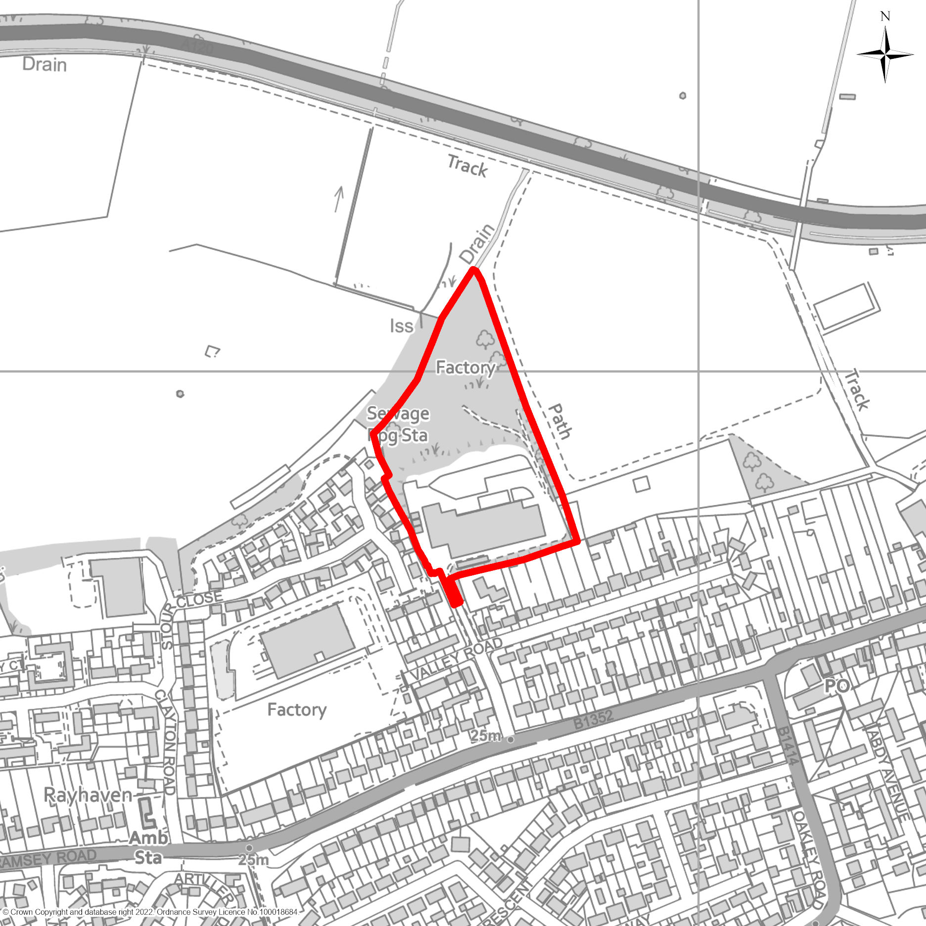
MSA2 Land adjacent to Branscombe Close, Frinton
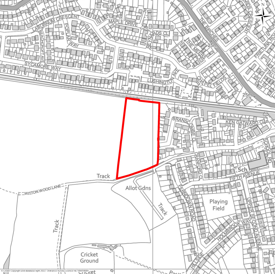
MSA3 Affinity Water, Mill Hill, Manningtree
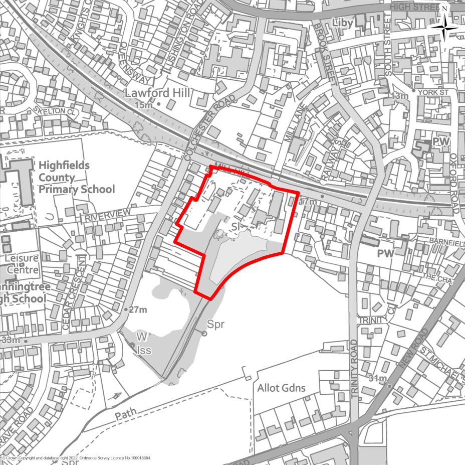
MSA4 Crisp Malting, School Lane, Mistley
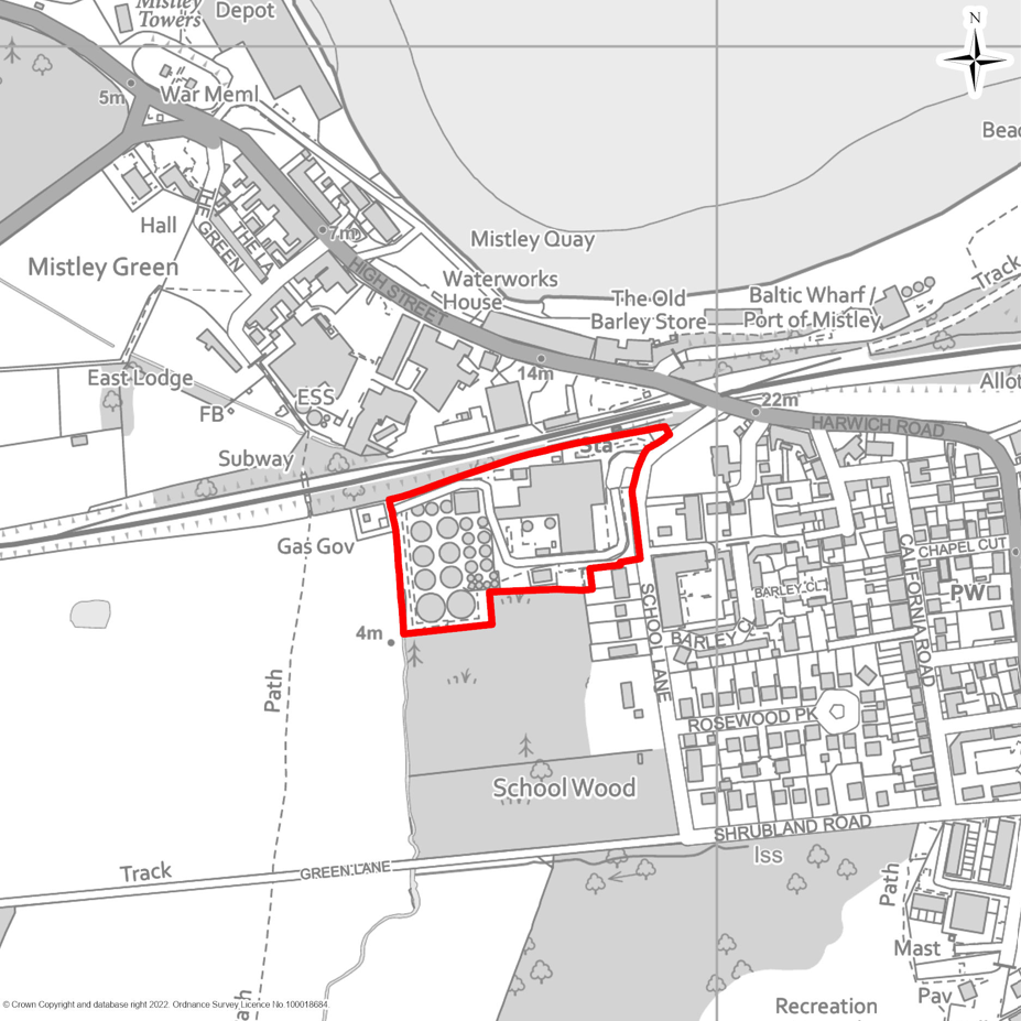
MSA5 Brightlingsea Telephone Exchange, 16 New Street, Brightlingsea
MSA6 Land at Pannell Place, Brightlingsea
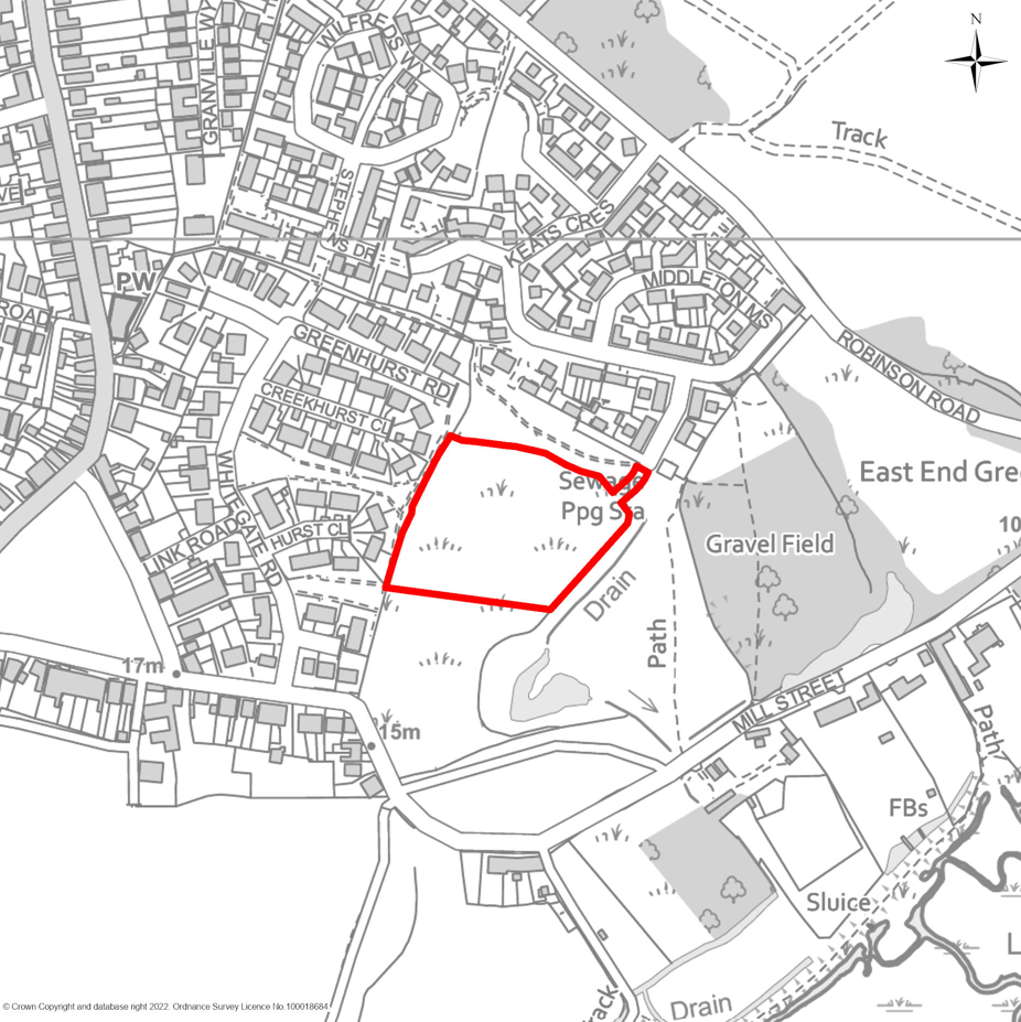
MSA7 Land south-west of Colchester Main Road, Alresford
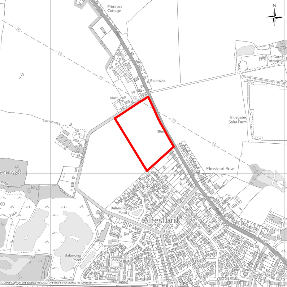
MSA8 Land adjacent Village Hall, Harwich Road, Beaumont
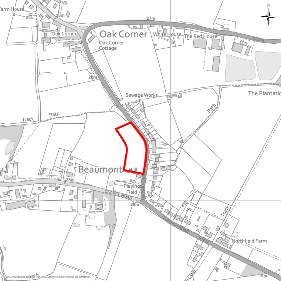
MSA9 Land south of Windmill Road and east of Straight Road, Bradfield
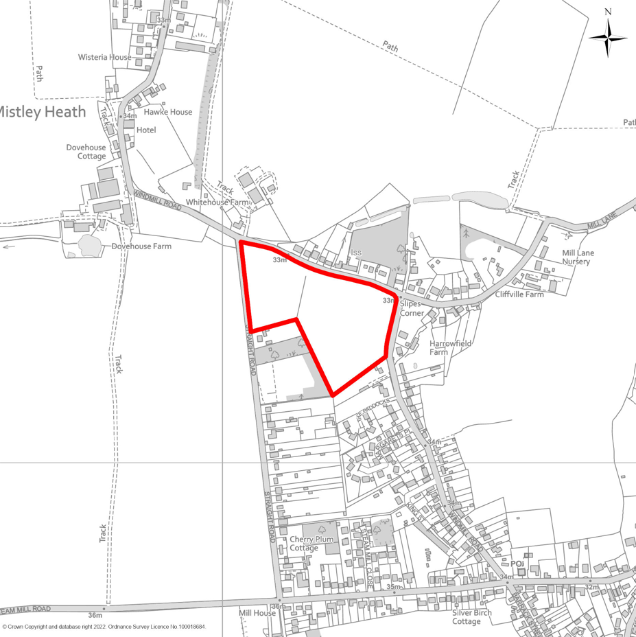
MSA10 Land south of Weeley Road, Great Bentley
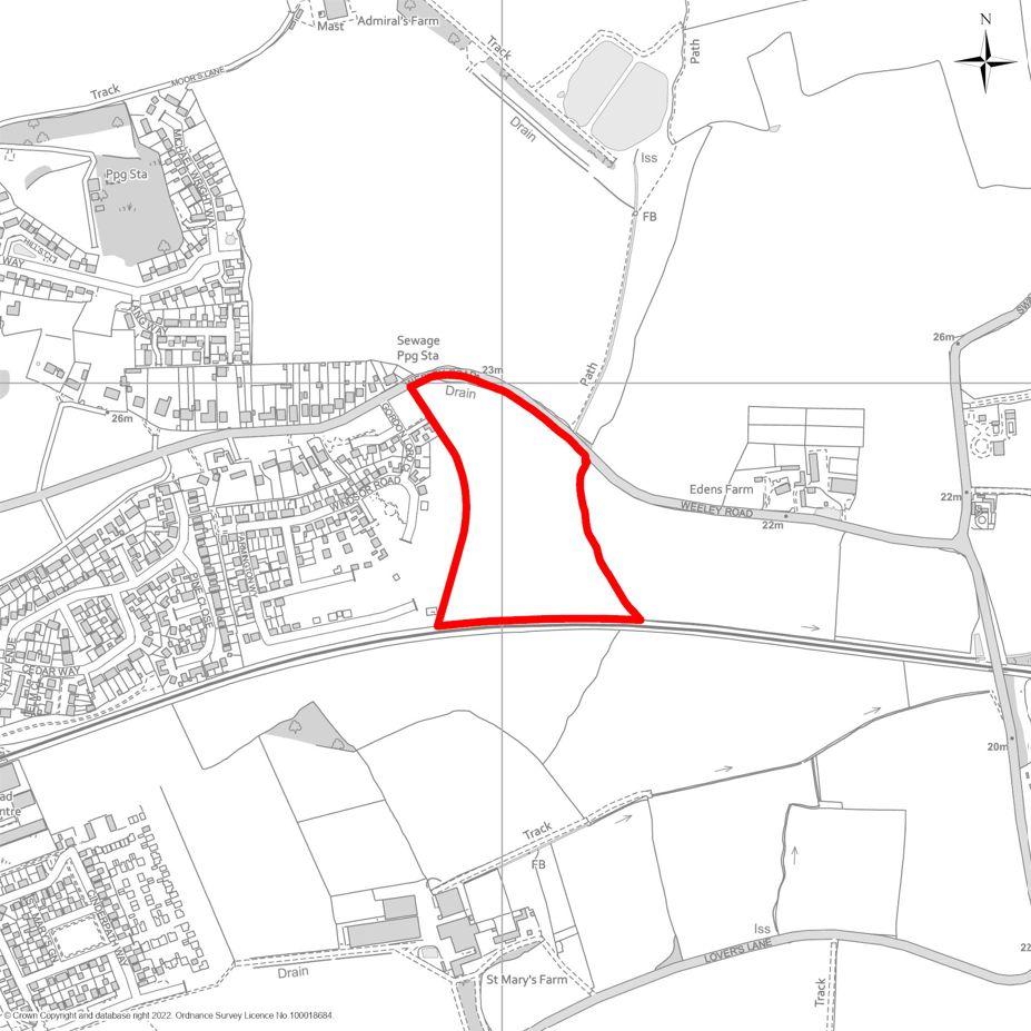
MSA11 Land west of Parsons Hill, Great Bromley
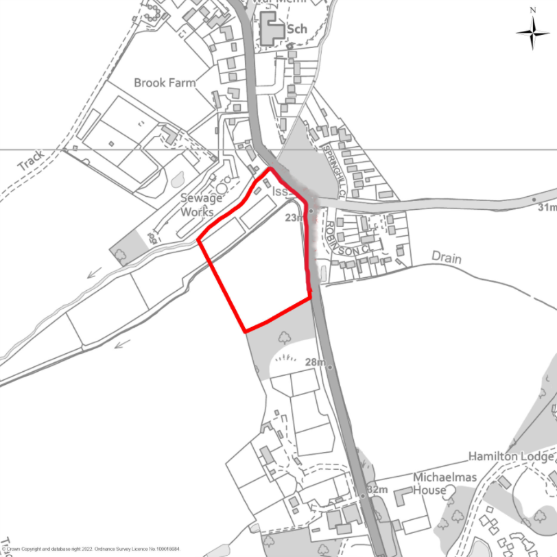
MSA12 Land south of Hall Road, Great Bromley
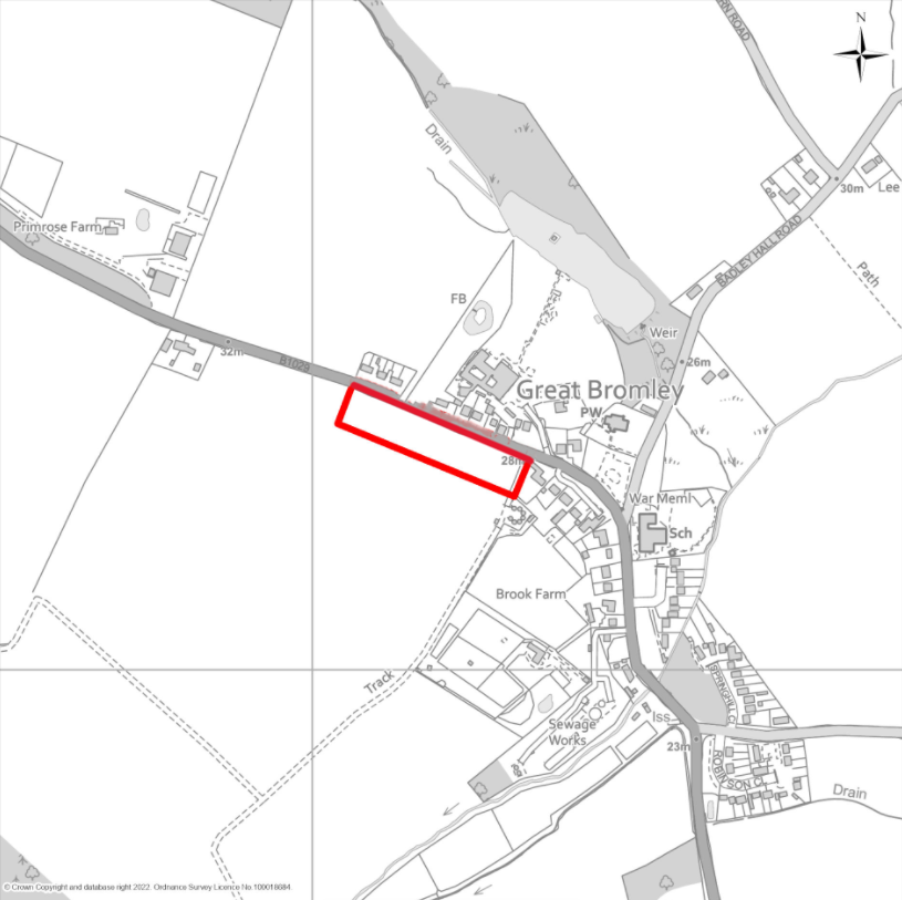
MSA13 Land west of Main Road, Great Holland
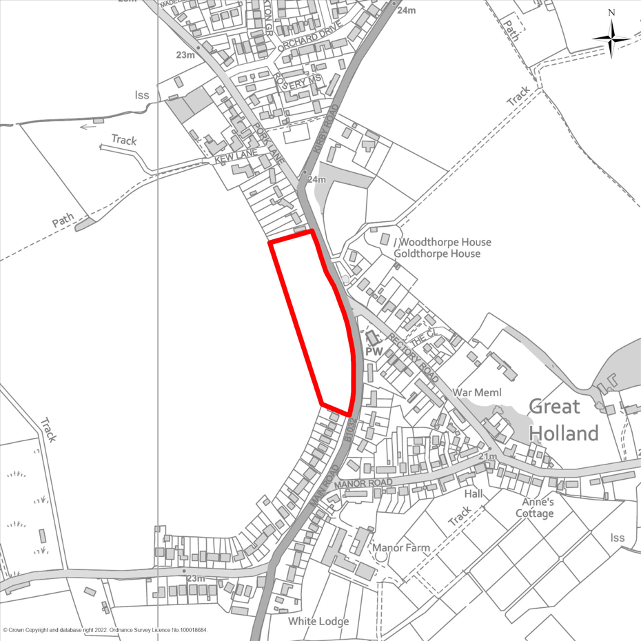
MSA14 Land east of Kirby Road, Great Holland
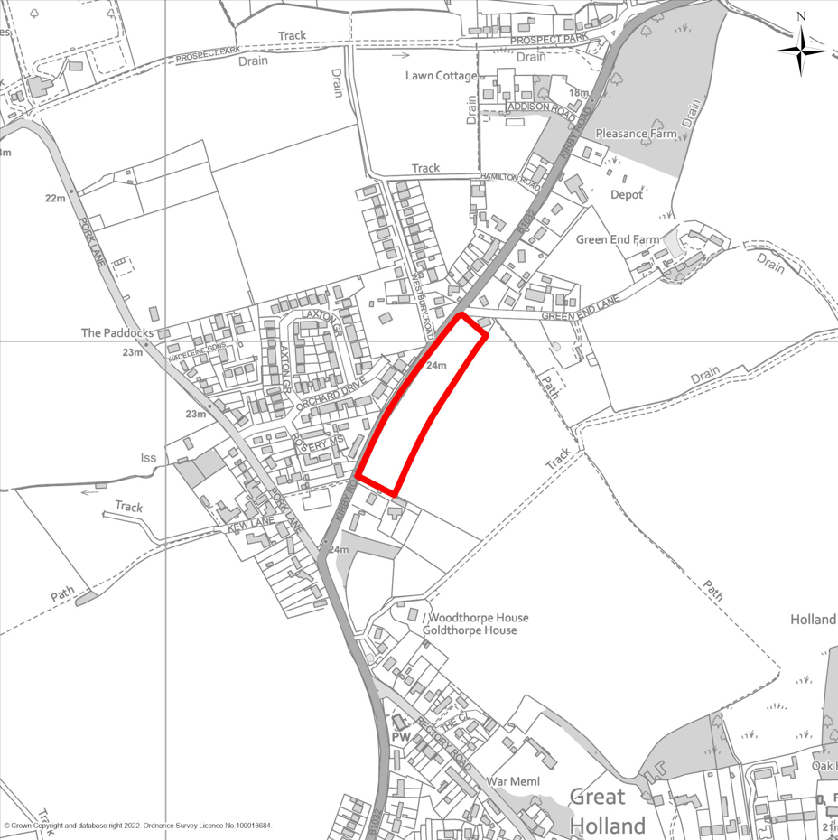
MSA15 Land north-east of Wix Road, Great Oakley
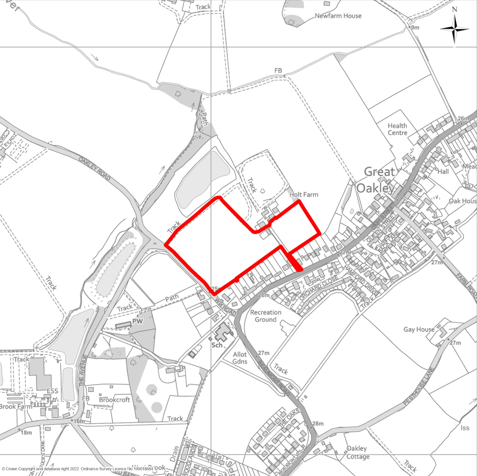
MSA16 Land south of Orchard Close, Great Oakley
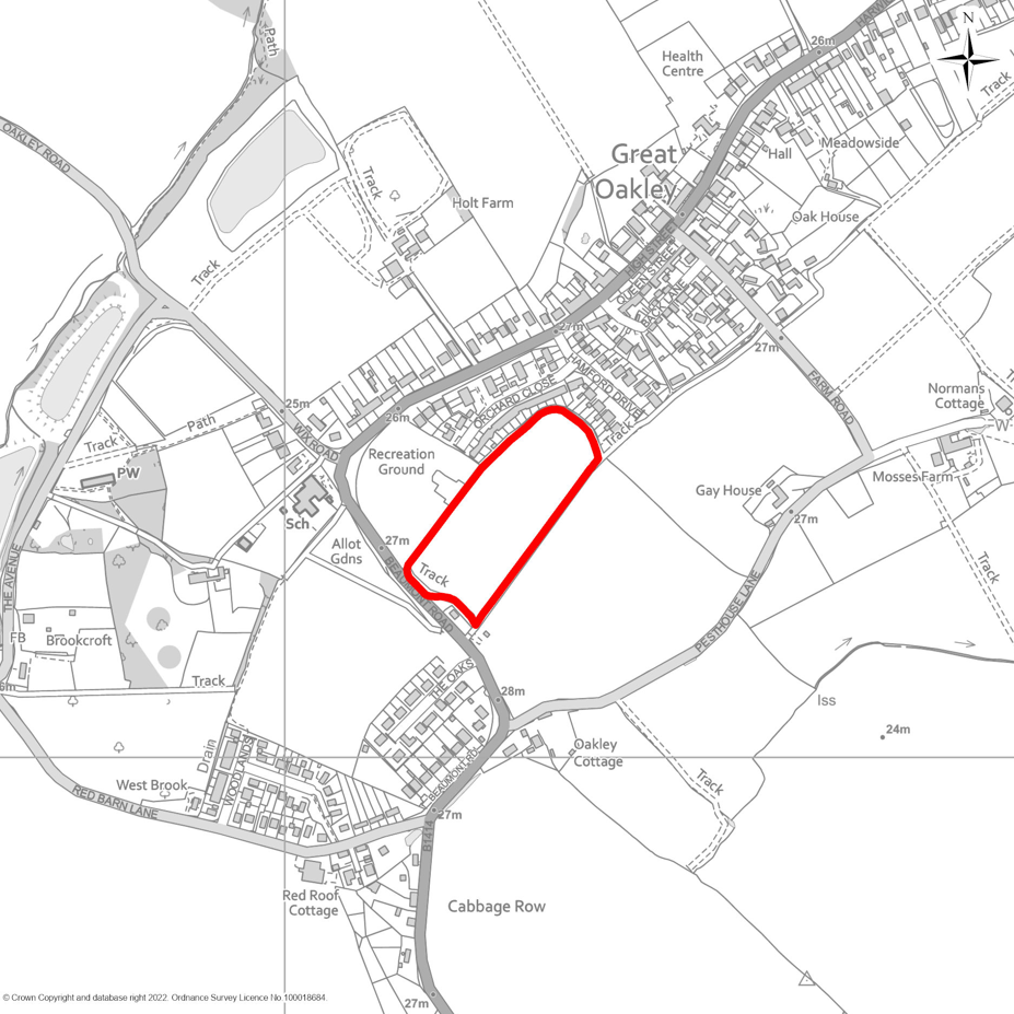
MSA17 Land north of Walton Road, Kirby-le-Soken
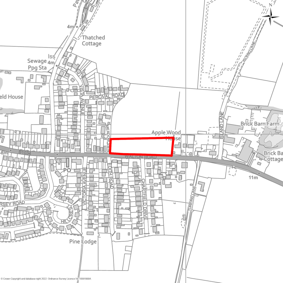
MSA18 Land north of Kirby-le-Soken Evangelical Church, Kirby-le-Soken
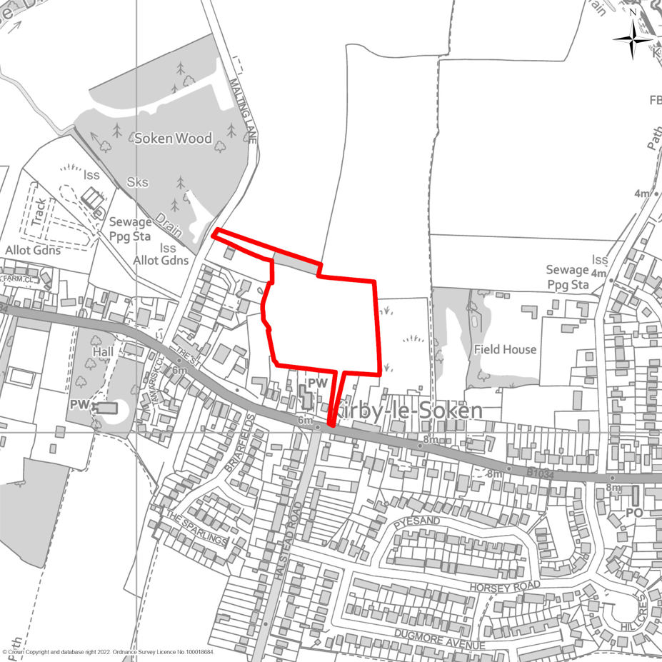
MSA19 Land west of Manningtree Road, Little Bentley
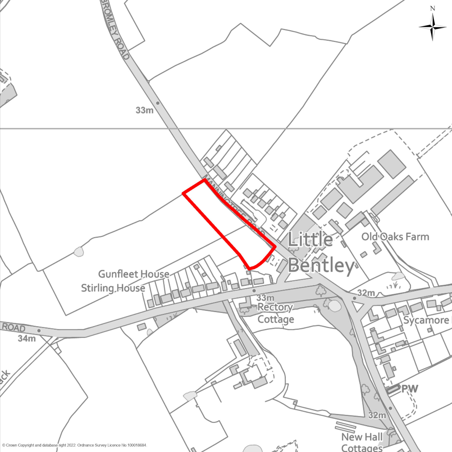
MSA20 Land south of Shop Road, Little Bromley
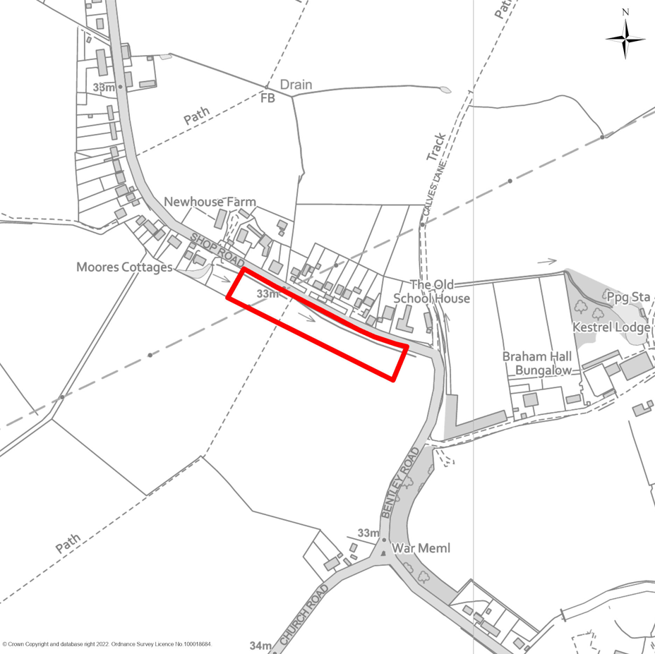
MSA21 Land east of Heckfords Road, Great Bentley
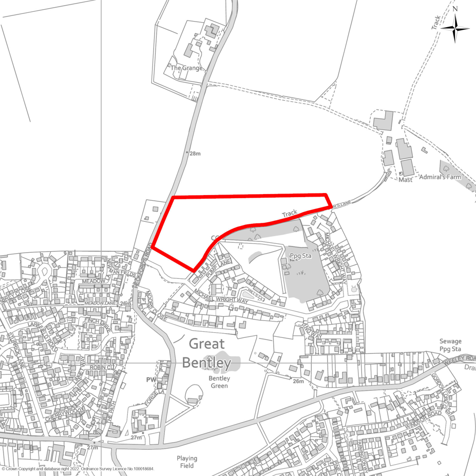
MSA22 Haulage Depot, Heath Road, Tendring Green
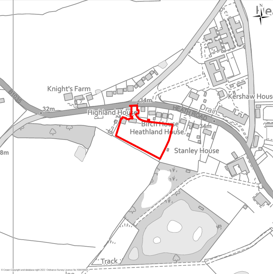
MSA23 Land at Avocet Place, Thorrington
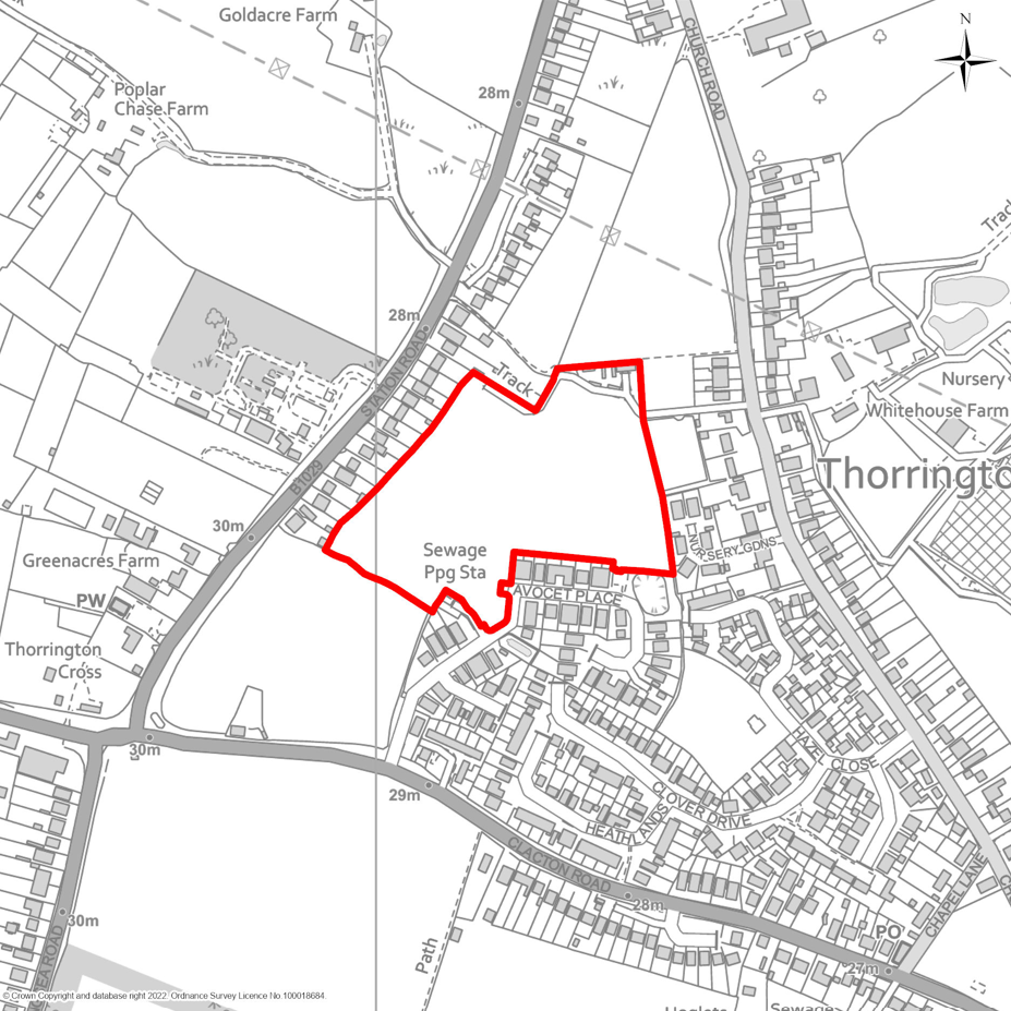
MSA24 Land east of Bentley Road, Weeley Heath
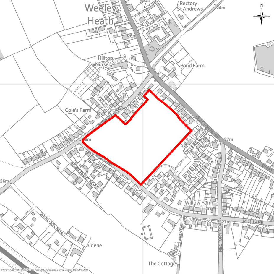
MSA25 Land south of Mill Lane, Weeley Heath

MSA26 Land south of Colchester Road, Wix
MSA27 Land at Abbey Bottom Farm, Harwich Road, Wix
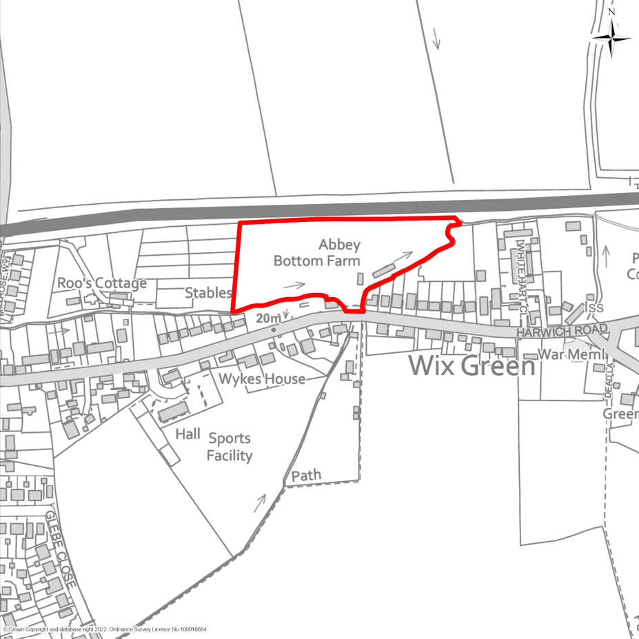
MSA28 Land north of Rectory Road, Wrabness
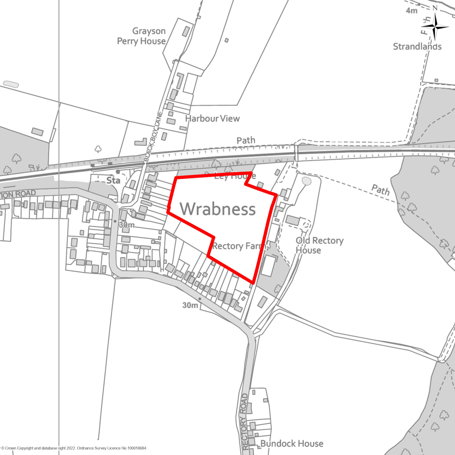
MSA29 Land at Weeley Council Offices
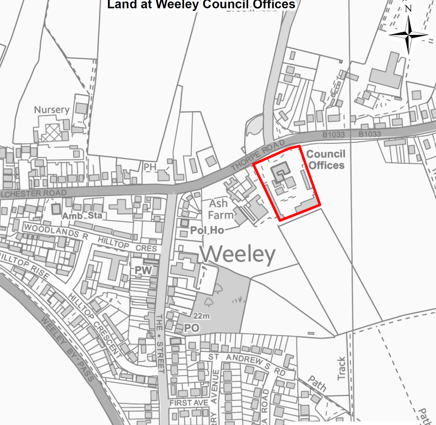
MSA30 Former Tendring Hundred Waterworks Site, Clacton
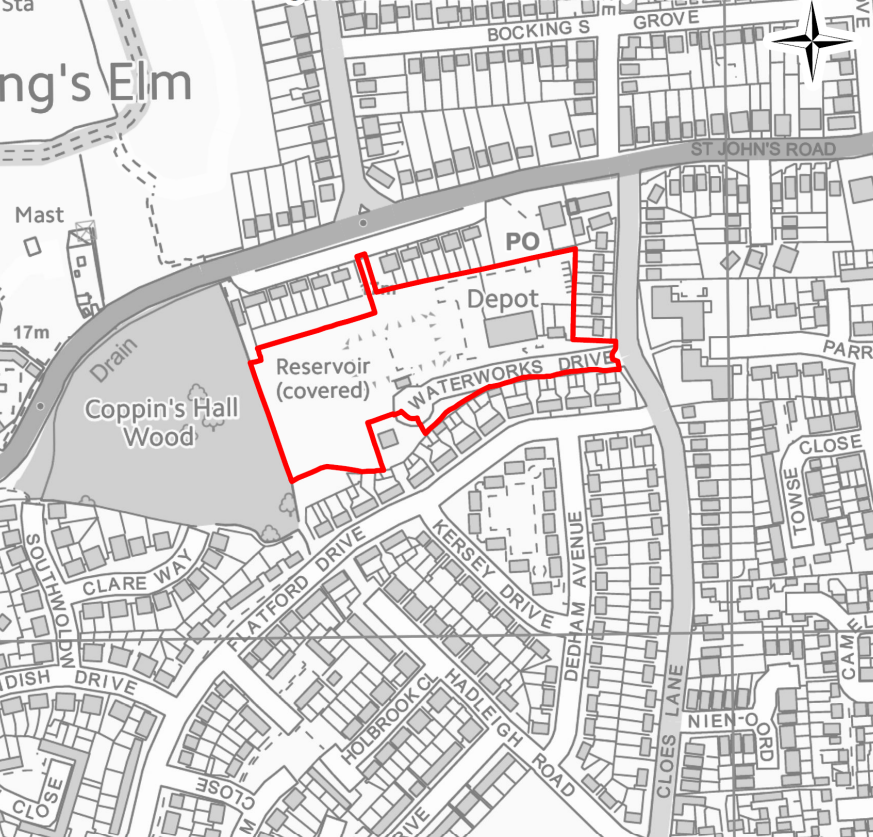
MSA31 Land adjoining Harwich & Parkeston Football Club, Dovercourt
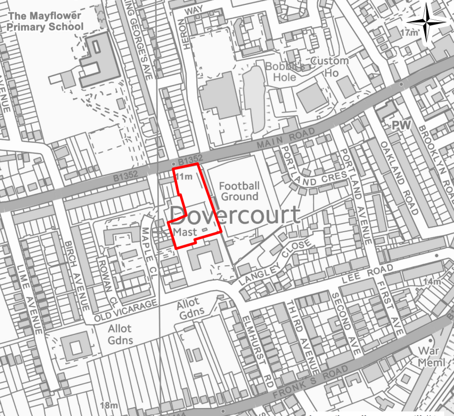
MSA32 Station Yard / Avon Works, Walton
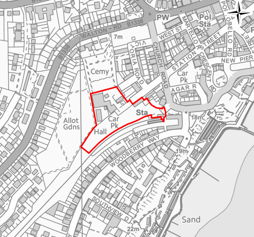
Strategic Allocations for Employment
SAE1 – Carless Extension, Harwich
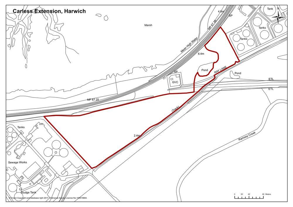
9.96The Carless Refinery to the west of the village of Parkeston contains a range of large storage tanks to enable the mixing of solvents and other materials. The land incorporating the existing refinery is safeguarded for this continued use. In view of health and safety requirements relating to the operation of the refinery and the need for safeguarded areas around it, only a limited expansion will be possible between the northern boundary of the site and the railway line.
9.97Owing to the varied nature of land ownership in the proposed area between Carless Refinery and National Rail, it will be necessary to engage with all parties in order to deliver the most suitable proposal.
CARLESS EXTENSION, HARWICH
Land west of Carless Refinery, shown on the Map SAE1, is proposed for an extension of the existing refinery.
Proposals must accord with the following:
- assessment of any impact on nature conservation, including on the Stour and Orwell Estuaries SPA and Ramsar site, and the recently extended Suffolk Coast and Heaths Area of Outstanding Natural Beauty (AONB) should be undertaken. Development will only be permitted where a project level assessment has demonstrated in accordance with the Habitat Regulations, that any proposal will not adversely affect the integrity of the Stour and Orwell Estuaries SPA and Ramsar site, either alone or in combination. If significant effects are considered likely, an appropriate mitigation strategy should be submitted;
- assessment of any impact on the landscape character should be undertaken and where impacts are identified, mitigation measures should be submitted including structural landscaping at the southern boundary;
- the proposed development must not compromise the safeguarded mineral transhipment site located in the vicinity. Early engagement with the Minerals Planning Authority is therefore encouraged; and
- that there would be no material adverse impacts on the adjacent wildlife sites.
SAE2 – Freeport East, Bathside Bay and the A120 corridor
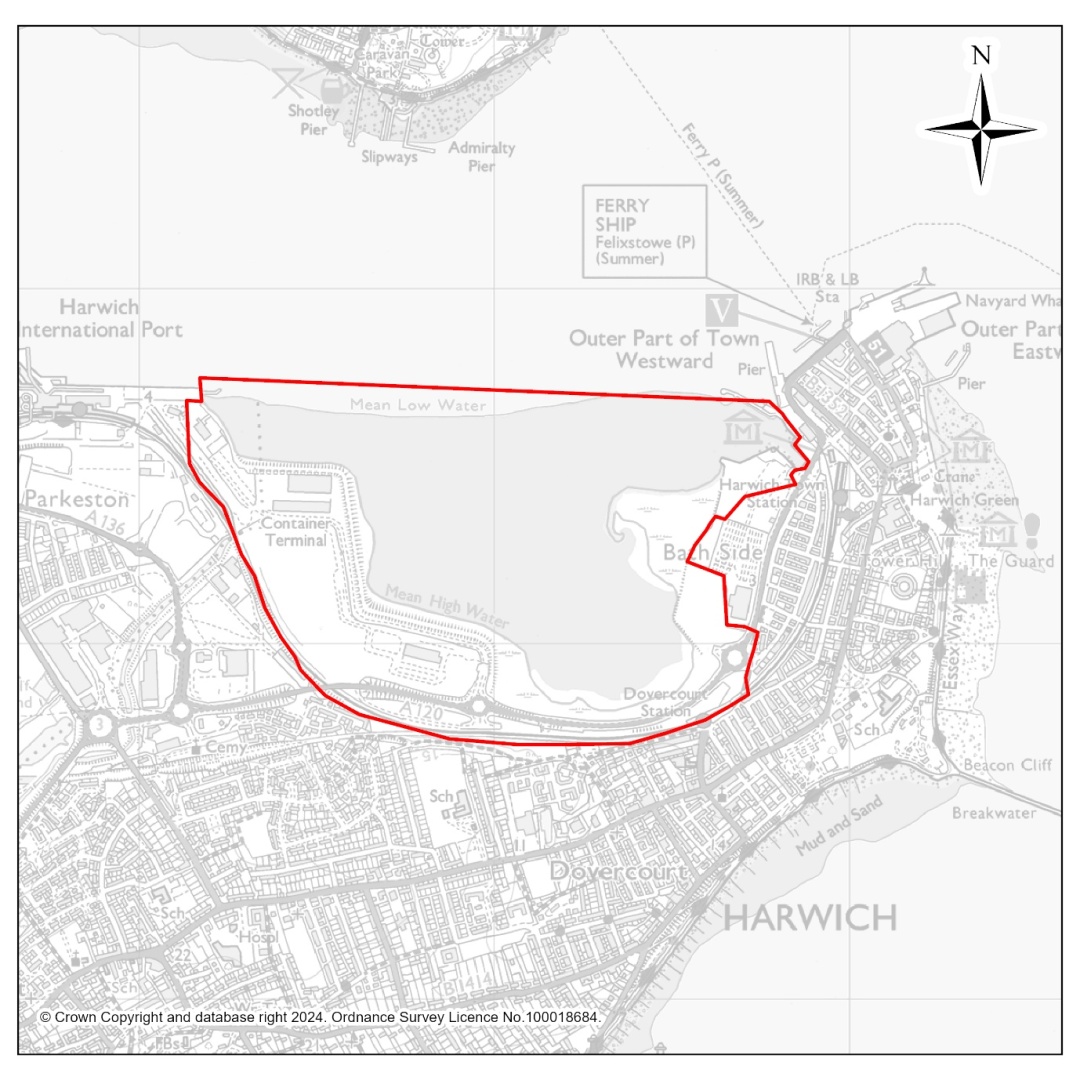
9.98In 2021, the government designated 12 areas across the United Kingdom as ‘Freeports’ with significant tax and customs incentives aimed at boosting new investment, tackling deprivation and supporting innovation and development in green energy. Tendring is part of the ‘Freeport East’ area straddling North Essex and South Suffolk where there is a particular focus on growth at and around the ports of Harwich and Felixstowe and strategic sites along the A120 and A14 corridors. Through partnership working between central government, local Councils, the business community and others, a range of interventions and incentives are being developed with an aim to create the conditions for creating around 13,500 new jobs over 10 years. The potential for residents and businesses in Tendring to benefit from the designation of Freeport East and associated opportunities for investment and job creation is significant, particularly for the Harwich area and parts of the District along the wider A120 corridor.
9.99These opportunities been recognised in recent years through the substantial investment from the owners of Harwich International Port in securing planning permission for the long-term expansion of the port to handle containers and commencing the first phase of that development, whilst also seeking the necessary consents from the Council and the Marine Management Organisation (MMO) for the major habitat compensation schemes at Hamford Water that will be necessary to enable the next phases of the development to proceed. Planning permission has also been secured for a temporary 15-year period for a ‘Green Energy Hub’ at the port that will serve the construction, servicing and maintenance of offshore windfarm installations and create new jobs in the short to medium term while the longer-term expansion for the container terminal is progressing.
9.100Significant private investment has also gone into the construction of ‘Centurian Park’, the first phase of a new business area at Horsley Cross and additional land is identified in this Local Plan for further phases of development that will benefit from the incentives offered by Freeport designation and deliver additional job opportunities over the period of this Local Plan.
9.101The strategy for growth in this Tendring Local Plan has been amended to both reflect the opportunities offered by Freeport East and the developments at Bathside Bay, Horsley Cross and elsewhere along the A120 corridor; and to support the ambition for growth. This includes strategic housing allocations to meet an anticipated increase in demand generated by existing and future residents from the local area looking to obtain training, skills and work and wanting to raise their families locally, as well as demand from people likely to move into the area for work. The strategy for growth in the Local Plan also sees the improvement to and upgrading of the A120 as critical to future economic success and the planned housing and employment growth in the north of the District.
9.102As a condition of the planning permission for the Bathside Bay Container Terminal, a number of improvements to the A120 are required to ensure it has the capacity to accommodate additional lorry and car traffic and continues to operate in an efficient and safe manner. These include alterations and improvements to the A12/A120 Crown Interchange at Ardleigh and the A120 Parkeston Road/Station Road/Europa Way roundabout; dualling of the A120 between the Hare Green interchange and Horsley Cross; and widening of the A120 between Horsley Cross and Ramsey Bridge roundabout, with potential re-routing in some locations.
9.103As well as these upgrades, the Tendring Colchester Borders Garden Community is to be accompanied by a link road from the A120 north of Crockleford Heath to the A133 west of Elmstead Market; and through the Hare Green Garden Village development, it is proposed that an omni-directional junction is constructed to enable deliver better north-south connectivity across the direct and faster and more direct movement for lorries and cars between the Harwich and Clacton areas.
FREEPORT EAST, BATHSIDE BAY AND THE A120 CORRIDOR
To maximise the opportunities for economic growth and job creation following the designation of Freeport East, the spatial strategy and policies in this Local Plan support the development at Bathside Bay, new and expanded business and industrial parks in strategic locations along the A120 corridor supported by housing and mixed-use development in Harwich and Dovercourt, at the Tendring Colchester Borders Garden Community and at the proposed Hare Green Garden Village at Frating and Hare Green. These developments will need to be supported by, and will be required to assist in facilitating, improvements to (and the upgrading of) the A120 and associated junctions in Tendring.
Bathside Bay, as shown on Map SAE2 is allocated in this Local Plan for the construction of an operational container terminal alongside a new small boat harbour – for which planning permission has been granted and development has commenced. Planning permission has also been granted for use of part of the proposed container terminal, on a temporary basis, for a ‘Green Energy Hub’ to support the offshore wind industry. The Council will work with Freeport East, central government, the owners of Harwich International Port and other relevant agencies and partners to accelerate, where possible, the delivery of the consented developments and related infrastructure improvements in order to support the local economy and creation of local jobs. Development proposals that would prejudice or frustrate the development of Bathside Bay will not be supported.
In support of a long-term strategy for growth along the A120 corridor, land is also allocated through Policy PP7 of this Local Plan for new and expanded business and industrial parks north of the A120 at Parkeston; with employment sites also proposed as an integral part of the proposed Hare Green Garden Village, Horsley Cross Garden Village, and the Collierswood Farm Business Park, north of the future Tendring Colchester Borders Garden Community.
The Council will also work with partners to explore all other means by which the improvement and upgrading of the A120 can be delivered and accelerated in support of the strategy for growth in this Local Plan, which could include the use of Community Infrastructure Levy (CIL) or other contributions secured from new development along the A120 corridor. These improvements could include:
- alterations and improvements to the A12/A120 Crown Interchange at Ardleigh;
- the A120/A133 link road and associated junctions associated with the Tendring Colchester Borders Garden Community;
- an omni-directional junction at the A120/A133 interchange at Frating and Hare Green;
- the dualling of the A120 between Hare Green and Horsley Cross;
- the widening of the A120 between Horsley Cross and the Ramsey Bridge roundabout; and
- alternations and improvements to the A120 Parkeston Road/Station Road/Europa roundabout at Parkeston.
SAE3 – Collierswood Farm Business Park
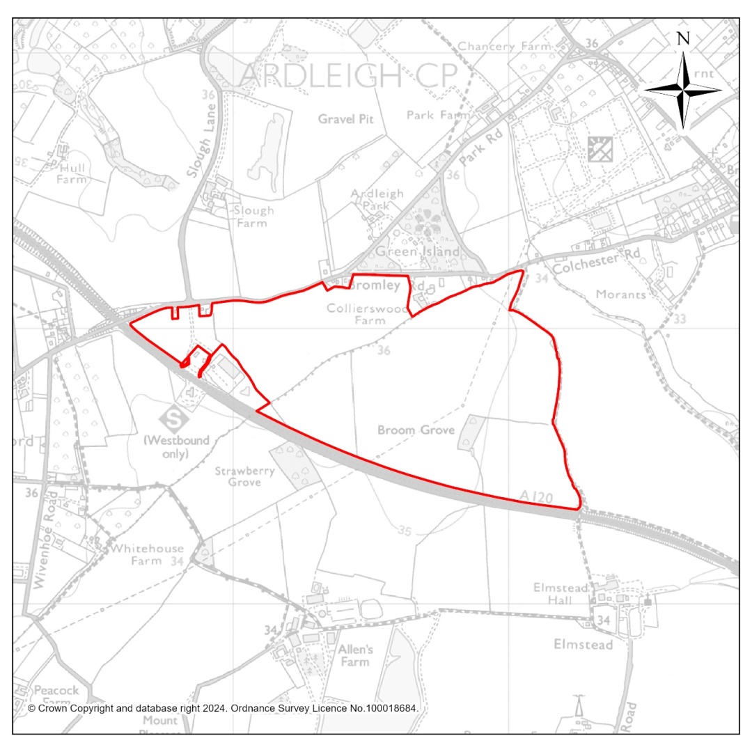
9.104Land north of the A120 is allocated for a future Strategic Business Park to be accessed via the grade-separated junction proposed to be built at the northern end of the new A120/A133 link road (A1331) which is being built alongside the Tendring Colchester Borders Garden Community. At 78 hectares in size, this Business Park will be of sub-regional significance; strategically located to attract inward investment and deliver jobs for existing Tendring residents and future residents of the Tendring Colchester Borders Garden Community, as well as serving economic growth ambitions of neighbouring Colchester and the wider Freeport East area.
9.105The delivery of this Strategic Business Park is wholly dependent on the completion of the A120/A133 link road (A1331) for access from the grade-separated junction and access will not be permitted from any other rural road (other than by active travel). This development will therefore be expected to assist in facilitating the early completion of the link road, associated junctions and infrastructure. The development will also be connected to the Rapid Transit System serving the wider Garden Community to maximise the opportunity for people to get to work by public transport.
9.106Landscaping will be an important feature of this development, both internally and throughout the development itself to create a high-quality urban environment; and around the northern periphery of the site to minimise its visual impact on the wider rural area.
COLLIERSWOOD FARM A120 STRATEGIC BUSINESS PARK
Land north of the A120 in Elmstead Market is allocated for a Strategic Business Park of sub-regional significance that will be accessed only via the grade-separated junction to be built as part of the A120/A133 (A1331) link road serving the Tendring Colchester Borders Garden Community. To ensure early delivery, the development will be expected to facilitate and contribute towards the completion of the link road, associated junctions and infrastructure through land provision and/or financial contributions secured through s106 legal agreements, Community Infrastructure Levy (CIL) or other appropriate means.
Masterplan Requirement
A comprehensive masterplan must be prepared and approved prior to or alongside the first planning application, in consultation with Tendring District Council and Colchester City Council (or relevant local planning authorities). The masterplan must:
- Define the spatial layout, movement network, and land use distribution.
- Set design parameters for building heights, massing, and typologies.
- Establish landscaping, biodiversity, and green and blue infrastructure strategies including sustainable drainage systems.
- Include a phasing and delivery plan, viability testing, and monitoring framework.
- Define a strategy for sustainable development that minimises impacts on climate change that includes design, layout and the use of renewable technologies.
- Ensure alignment of all design standards with the Essex Design Guide.
Design and Development Principles
The masterplan and subsequent applications must deliver a high-quality, sustainable employment environment based on the following principles:
1. Placemaking and Social Value
Adopt a landscape-led approach retaining existing trees and hedgerows where possible and creating multifunctional green infrastructure. The LNRS suggests a need for woodland specific habitat enhancement on this site.
- Provide shared social spaces, cafés, and informal meeting areas to foster collaboration.
- Provide public realm features such as landscaped plazas and outdoor seating with Wi-Fi to encourage flexible working.
- Provide a mix of unit sizes and typologies (large industrial, logistics, research and development, and office spaces) to ensure flexibility and adaptability over time.
2. Connectivity and Access
- Facilitate and contribute to the early delivery of the A120/A1331 link road, associated junctions and infrastructure through agreed mechanisms.
- Integrate with the Rapid Transit System. Additional local public transport services should also be provided to the site.
- Design integrated measures to mitigate the transport impacts of the proposed development on the strategic and local road network.
- Emergency access points should be planned, and an active travel crossing of the A120 from the Garden Community should be explored.
- Foot and cycle ways should be provided throughout the development and connecting with the surrounding settlements and countryside. The Public Rights Of Way network across the site must be protected and enhanced.
- Ensure safe, convenient pedestrian and cycle connections to the Garden Community.
- Incorporate active travel priority routes, bus priority measures, and a goods vehicle routing strategy.
- Provision for a trunk road service area including lorry parking must be indicated.
- Provision of electric vehicle charging, secure cycle storage, and last-mile logistics hubs.
- To facilitate the RTS terminus, the masterplan should consider provision for a public transport maintenance depot.
3. Environmental Sustainability
- Achieve a minimum 20% Biodiversity Net Gain through robust landscape buffers, tree planting, and habitat creation.
- Implement Sustainable Drainage Systems (SuDS), rainwater harvesting, and green roofs.
- The applicant must demonstrate adequate wastewater capacity, including any necessary phasing or alternative solutions, to the satisfaction of both the Council and Anglian Water.
- Provision of appropriate design and infrastructure that incorporates the highest standards of innovation in energy efficiency and technology to reduce impact of climate change, water efficiency (with the aim of being water neutral in areas of serious water stress), and sustainable waste / recycling management facilities.
- Undertake embedded carbon assessments and apply circular economy principles, supported by defined life-cycle carbon reduction targets.
4. Heritage and Amenity
- Preserve and enhance the setting of nearby heritage assets.
- Incorporate noise attenuation, air quality mitigation, and lighting control measures to protect residential amenity.
5. Highways and Junction Modification
- Any changes to the already approved junction needed to achieve suitable access and capacity for the additional business park development must be funded entirely by the developer, secured through appropriate legal agreements (such as Section 106) or other agreed mechanisms.
- The developer must fund and deliver all necessary modifications to the junction and approaches to accommodate active and sustainable travel measures
If Collierswood Farm is delivered ahead of the Tendring Colchester Borders Garden Community (TCBGC), it must fund and deliver Phase 2 junction and approaches as currently designed, plus any changes required to provide safe access for all modes, including connection to Phase 1 at Allen’s Farm Roundabout.
- Walking, cycling, and public transport links and services to the Garden Community must be funded and delivered by the developer.
Contributions will be secured towards mitigation measures in accordance with the Essex Coast Recreational disturbance Avoidance and Mitigation Strategy.
Policy Compliance and Monitoring
- A monitoring framework must track delivery of infrastructure, biodiversity net gain, carbon reduction, and sustainable transport measures.
Collierswood Farm represents a prime strategic employment location, capable of delivering a high-quality, sustainable business park of sub-regional significance. Its success will depend on infrastructure delivery and adherence to best practice design principles, ensuring the creation of an attractive, connected, and environmentally responsible employment hub.